
Toyohira (river)
| Toyohira | ||
 the Toyohira in the center of Sapporo |
||
| Data | ||
| location | Japan | |
| River system | Ishikari | |
| Drain over | Ishikari → Sea of Japan | |
| source | at Oizari-dake, Minami-ku (Sapporo) 42 ° 47 ′ 31 ″ N , 141 ° 13 ′ 1 ″ E |
|
| Source height | 850 m TP | |
| muzzle | at Higashi-ku (Sapporo) coordinates: 43 ° 9 ′ 4 " N , 141 ° 26 ′ 58" E 43 ° 9 ′ 4 " N , 141 ° 26 ′ 58" E |
|
| Mouth height | 2 m TP | |
| Height difference | 848 m | |
| Bottom slope | 12 ‰ | |
| length | 72.5 km | |
| Catchment area | 894.7 km² | |
| Left tributaries | Bannosawa, Kitanosawa, Shōjin, Otarunai, Usubetsu, Yamahana | |
| Right tributaries | Anano, Atsubetsu, Makomanai , Misumai | |
| Reservoirs flowed through | Jozan Lake | |
| Big cities | Sapporo | |
The Toyohira ( Japanese 豊 平川 , Toyohira-gawa ) is a river on the Japanese island of Hokkaidō . It is 72.5 km long and has a 894.7 km² catchment area . It flows along its entire length through the urban area of Sapporo until it flows into the Ishikari .
description
The source is located in the extreme south of the metropolitan area on Oizari-dake, a tributary summit of Izari-dake , at an altitude of 850 m TP as a mountain stream of Toyohira first flows to the northwest, then north until it reaches the Józan Lake. This reservoir is around five kilometers long and is dammed by the 102.5 m high Hōheikyō Dam . It is named after the Hōhei Gorge, which is then crossed. Jōzankei, the first place on the river, is the location of a well-known onsen . Up to this point the river lies entirely in the area of the Shikotsu-Tōya National Park . The Toyohira now turns eastward and the area becomes increasingly urban after passing the Toyama Dam.
After the confluence of the Anano there is another distinctive bend in the north. The Makomanai flows into the Makomanai Park . The city center, which arose on a seven-kilometer-wide alluvial cone of the Toyohira, is passed on its east side. The Sōsei Canal branches off here, an irrigation canal created in the 1860s. The now north-east running river reaches the extensive Ishikari plain , receives the longest tributary with the Atsubetsu and flows into the Ishikari at the border to Ebetsu . This in turn flows a few kilometers further north into the Sea of Japan .
photos

Jozan Lake
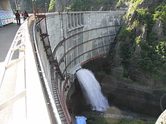
Hōheikyō Dam

the Toyohira at Jōzankei
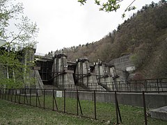
Toyama Dam

Heiwa Bridge


Web links
Individual evidence
- ↑ Sung Gi Hu: Study on the relation between groundwater and surface water in Toyohiro-gawa alluvial fan, Hokkaido, Japan . In: Makoto Taniguchi, Ian P. Holman (Eds.): Groundwater response to changing climate . CRC Press, Boca Raton (Florida) 2010, ISBN 978-0-203-85283-5 , pp. 141 .
- ^ Map of the Shikotsu-Tōya National Park. (PDF, 2.4 MB) Japanese Ministry of the Environment, 2017, accessed on September 2, 2018 .
- ↑ School Board of the City of Sapporo (ed.): さ っ ぽ ろ 文庫 4 豊 平川. Hokkaidō Shimbunsha, 1978, p. 10.
- ↑ Ann B. Irish: Hokkaido: A history of ethnic transition and development on Japan's northern island . McFarland, Jefferson (North Carolina) 2009, ISBN 978-0-7864-4449-6 , pp. 161 .