Ebetsu
| Ebetsu-shi 江 別 市 |
||
|---|---|---|
|
|
||
| Geographical location in Japan | ||
| Region : | Hokkaidō | |
| Prefecture : | Hokkaidō | |
| Coordinates : | 43 ° 6 ' N , 141 ° 32' E | |
| Basic data | ||
| Surface: | 187.57 km² | |
| Residents : | 119,509 (September 30, 2019) |
|
| Population density : | 637 inhabitants per km² | |
| Community key : | 01217-3 | |
| Symbols | ||
| Flag / coat of arms: | ||
| Tree : | Rowanberry | |
| Flower : | Chrysanthemums | |
| town hall | ||
| Address : |
Ebetsu City Hall 6 Takasago-chō Ebetsu -shi Hokkaidō 067-8674 |
|
| Website URL: | http://www.city.ebetsu.hokkaido.jp | |
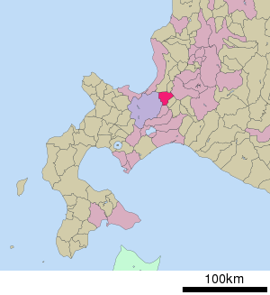
| Location Ebetsu in Hokkaidō Prefecture | ||
Ebetsu ( Japanese 江 別 市 , - shi ) is a city in the Ishikari sub-prefecture on the island of Hokkaidō ( Japan ).
geography
Ebetsu is southwest of Asahikawa and northeast of Sapporo .
history
The city has existed since April 1, 1954.
traffic
The city is on the Hakodate Main Line from JR Hokkaido . This opens up the Ōasa, Nopporo , Takasago, Ebetsu and Toyohoro train stations.
Ebetsu can be reached via the Dōō Highway , as well as National Road 12 , National Road 275, and National Road 337.
Town twinning
-
 Gresham, Oregon , since 1977
Neighboring cities and communities
sons and daughters of the town
- Keisuke Ushiro (* 1986), athlete
Web links
Commons : Ebetsu - collection of images, videos and audio files


