Biratori
| Biratori-chō 平 取 町 |
||
|---|---|---|
| Geographical location in Japan | ||
|
|
||
| Region : | Hokkaidō | |
| Prefecture : | Hokkaidō | |
| Coordinates : | 42 ° 35 ' N , 142 ° 8' E | |
| Basic data | ||
| Surface: | 743.16 km² | |
| Residents : | 4997 (September 30, 2019) |
|
| Population density : | 7 inhabitants per km² | |
| Community key : | 01602-1 | |
| Symbols | ||
| Flag / coat of arms: | ||
| Tree : | Japanese cake tree | |
| Flower : | lily of the valley | |
| town hall | ||
| Address : |
Biratori Town Hall 28 , Honchō Biratori -chō, Saru-gun Hokkaidō 055-0192 |
|
| Website URL: | http://www.town.biratori.hokkaido.jp/ | |
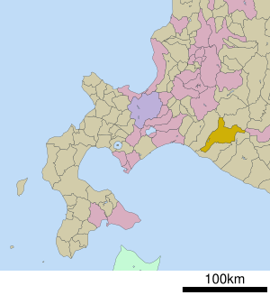
| Location Biratoris in Hokkaido Prefecture | ||
Biratori ( Japanese 平 取 町 , - chō , Ainu : pira utur ) is a city in the sub-prefecture of Hidaka on the island of Hokkaidō in Japan . It belongs to the Saru County .
geography
The Saru River , which gives the district its name, flows through the municipality from north to south towards the coast. It was dammed at the Nibutani Dam in Nibutani (二 風 谷). The municipality follows the geographic shape of the Saru valley. earlier there was also a freight railway running through the valley. Today the connection to the outside world is the national road 237 .
There was fierce opposition to the construction of the dam because the land is ancestral, holy land of the Ainu . In Nibutani there is also the municipal Ainu-Kultur-Museum Nibutani ( Nibutani Ainu bunka hakubutsukan 二 風 谷 ア イ ヌ 文化 博物館 , English Nibutani Ainu Cultural Musueum ) and an "Ainu Cultural Center". The Cultural Landscape along the Saru River resulting from Ainu Tradition and Modern Settlement (English for Ainu no dentō to kindai kaitaku ni yoru Sarugawa ryūiki no bunkateki keikan ) in Biratori was included in the list of cultural landscapes of Japan ( 文化 的 景 観 , bunkateki keikan ) .
The municipal administration is located on the Saru, about 4 km south of the Nibutani Dam. Directly on the dam there is a branch of the MLIT Development Office Hokkaidō to monitor the dam ( 二 風 谷 ダ ム 管理所 , Nibutani damu kanrisho ).
Surrounding communities
|
Mukawa Iburi |
Shimukappu Kamikawa |
Hidaka Hidaka-ku Tokachi |
|
Mukawa Iburi |

|
Niikappu |
| Hidaka |
Hidaka Monbetsu-ku |
Hidaka |
economy
Biratori is a rural and agricultural community where a variety of fruits and vegetables are grown. Tomatoes make up a large part of the production. There is also a timber industry.
education
The place has five municipal primary schools ( shōgakkō , English elementary schools ), including the primary school Nibutani directly on the bank of the reservoir, and two middle schools ( chūgakkō , English mostly junior high schools ). There are also two prefectural schools in the city: the Biratori Special School ( 北海道 平 取 養護 学校 , Hokkaido Biratori yōgo gakkō ) and the Biratori High School ( 北海道 平 取 高等学校 , Hokkaidō Biratori kōtōgakkō , English Hokkaido Biratori High School ).
Attractions
- Biratori Onsen Yukara
- Family land
- The Suzuran field in Memu , where lilies of the valley bloom from May to June. The field covers 15 ha, making it the largest in Japan. It was opened to the public in 1963 but had to be closed for ten years in 1975 due to damage.
- in the 1970s and 1980s there was a UFO park (observation platform)
Personalities
- Ryo Fukui (1948-2016), jazz pianist
- Kayano Shigeru (1926–2006), the most important advocate of the Ainu, its language and culture in the 20th century.
Web links
- Official website
- Biratori Nibutani Ainu Culture Museum
- Nibutani Takumi no Michi
- Congregation Information Page (Japanese)
- nabunken.go
Individual evidence
- ^ Iwasaki-Goodman, M. Traditional food systems of Indigenous Peoples: the Ainu in the Saru River Region, Japan
- ↑ City Biratori: Pages of the museum
- ^ Database of Registered National Cultural Properties. Bunka-chō April 29, 2011.
- ↑ Bunka isan online ( 文化遺産 オ ン ラ イ ン , “Kulturerbe online”, website of the Bunka-chō ): Entry ア イ ヌ の 伝 統 と 近代 開拓 に よ る 沙 流川 流域 の 文化 的 景 観
- ↑ Kokudo-kōtsū-shō , Hokkaidō kaihatsu-kyoku ("Hokkaidō Development Office"), Muroran kaihatsu-kensetsu-bu ( 室 蘭 開 発 建設部 , "Muroran Development [and] Construction Department"): 二 風 谷 ダ ム 管理所
- ↑ City Biratori: 学校施設
- ^ "Administration of Hokkaidō" or "Hokkai Prefecture Administration" , Education Committee , Hidaka kyōiku-kyoku ("Education Office [for the school district] Hidaka"): List of schools (Japanese)


