Furano
| Furano-shi 富良野 市 |
||
|---|---|---|
| Geographical location in Japan | ||
|
|
||
| Region : | Hokkaidō | |
| Prefecture : | Hokkaidō | |
| Coordinates : | 43 ° 21 ' N , 142 ° 23' E | |
| Basic data | ||
| Surface: | 600.97 km² | |
| Residents : | 21,630 (September 30, 2019) |
|
| Population density : | 36 inhabitants per km² | |
| Community key : | 01229-7 | |
| Symbols | ||
| Flag / coat of arms: | ||
| Tree : | Japanese yew tree , Magnolia obovata | |
| Flower : | Rhododendron dauricum | |
| Bird : | Black woodpecker | |
| Fur animal : | Sciurus vulgaris orientis | |
| town hall | ||
| Address : |
Furano City Hall 1 - 1 , Yayoi-chō Furano -shi Hokkaidō 076-8555 |
|
| Website URL: | http://www.city.furano.hokkaido.jp | |
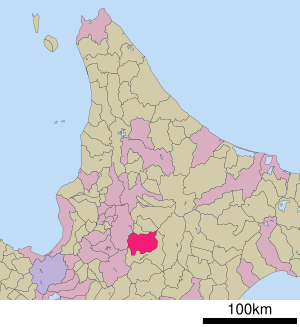
| Location Furanos in Hokkaidō Prefecture | ||
Furano ( Japanese 富良野 市 , - shi ) is a city in the Kamikawa sub-prefecture on the island of Hokkaidō .
geography
Furano is south of Asahikawa and northeast of Sapporo .
history
He was appointed Shi on May 1, 1966.
Attractions
The city is known for its colorful flower fields in summer and fragrant lavender in July.
Another tourist attraction is the from the current 1,981 to 2,002 drama Kita no Kuni kara known ROKURO no Mori ( 麓郷の森 ).
Town twinning
- Schladming ( Austria ), since 1977
traffic
The Furano Station is located on the Nemuro Main Line , which of Takikawa about Obihiro and Kushiro to Nemuro leads. Here the Furano line branches off to Asahikawa . Both lines are operated by JR Hokkaido .
Furano can also be reached via national roads 38 and 237.
Neighboring cities and communities
Web links
Commons : Furano - collection of images, videos and audio files


