Kutchan (Hokkaidō)
| Kutchan-chō 倶 知 安 町 |
||
|---|---|---|
| Geographical location in Japan | ||
|
|
||
| Region : | Hokkaidō | |
| Prefecture : | Hokkaidō | |
| Coordinates : | 42 ° 54 ' N , 140 ° 45' E | |
| Height : | 175 m | |
| Basic data | ||
| Surface: | 261.34 km² | |
| Residents : | 15,132 (September 30, 2019) |
|
| Population density : | 58 inhabitants per km² | |
| Community key : | 01400-1 | |
| Postal code area : | 044-00xx | |
| Symbols | ||
| Flag / coat of arms: | ||
| Tree : | Maple (acer pictum) | |
| Flower : | Rhododendron aureum | |
| town hall | ||
| Address : |
Kutchan Town Hall 3-3 Kita-ichijō-higashi Kutchan -chō, Abuta-gun Hokkaidō 044-0001 |
|
| Website URL: | town.kutchan.hokkaido.jp | |
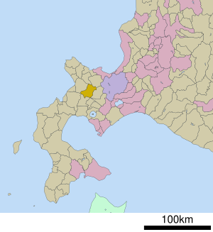
| Location of Kutchans in Hokkaidō Prefecture | ||
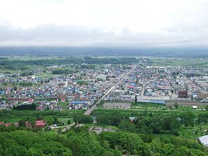
Kutchan ( Japanese 倶 知 安 町 , - chō ) is a small town on Hokkaidō in Japan . It belongs to Abuta County and is the administrative seat of the Shiribeshi Sub-Prefecture . Kutchan is about 50 km west of Sapporo .
geography
Kutchan is located on a small plain on the Shiribetsu River, which is bordered by several mountains. These include the striking volcano Yōtei-zan (1898 m) in the south and the Niseko Annupuri (1308 m) and the Niseko Iwaonupuri (1116 m) in the southwest.
climate
The climate in Kutchan is strongly influenced by the Sea of Japan . This leads to numerous warm and sunny days in spring and summer, but to extensive snowfalls in winter (due to the proximity to Siberia ). The highest snow depth was on March 25, 1970 with 312 cm, the lowest temperature was measured on January 27, 1945 with -35.7 ° C, the highest temperature on August 8, 1999 with 34.4 ° C.
|
Monthly average temperatures and rainfall for Kutchan
Source: Kutchan averages 1981-2010
|
|||||||||||||||||||||||||||||||||||||||||||||||||||||||||||||||||||||||||||||||||||||||||||||||||||||||||||||||||||||||||||||||||||||||||||||||||||||||||||||||||||||||||||||||||||||||||||||||||||||||||||||||||||||||||||||||||
Neighboring cities and communities
history
The place name Kutchan comes from the language of the Ainu , the indigenous people of Hokkaidō. It is derived from the word kut-shan-i , which can be translated as “place where the channel flows”. Another thesis says that the place name is derived from kucha-an-nai ("stream of a hunting lodge").
According to Nihonshoki history , Abe no Hirafu, governor of Koshi Province , conquered the area of what is now Shiribeshi sub-prefecture in 659. In 1892 the first settlers from Tokushima Prefecture settled in the area. They cleared the forest and began to cultivate the fertile soil. The area belonged from 1893 to the community of Abuta (today Tōyako ) and from 1896 formed an independent community. Benefiting from the construction of the railway, the population grew rapidly. 159 houses were destroyed in a major fire on July 1, 1908. The Japanese Ground Self-Defense Forces opened a barracks south of the city in September 1955. In the same year, the Hokkaido Speed Park racetrack opened , which was in operation until 2012.
The Austrian Major General Theodor Edler von Lerch came to Kutchan in 1912; he made skiing popular here and was the first to climb the Yōtei-zan on skis. Following his example, ski clubs from several universities began to organize trips to Kutchan and the surrounding area during the Taishō period . The first ski lift opened in 1961. With the hosting of national ski championships, Kutchan finally established itself as an important winter sports center.
economy
The original economic pillars are agriculture and forestry . This led companies in the food and wood processing industries to set up shop in Kutchan. A major company based in the city is Dōeishigyō , which manufactures toilet and tissue paper. Kutchan became famous as the center of a potato growing area . Here, among other gosetsu-udon made udon noodles made from potato flour.
In addition to these branches of industry, tourism plays an important role. The winter sports area Niseko Grand Hirafu on the eastern flank of Mount Niseko Annupuri is one of the most important on Hokkaidō. It is connected to other areas in the neighboring municipality of Niseko . Kutchan and Niseko are known worldwide for the high quality of the powder snow and are the destination of numerous tourists from other Asian countries as well as Australia . A golf course and hiking trails are available in summer ; you can also go rafting on the Shiribetsu .
traffic
Located west of the city center, Kutchan Station of the JR Hokkaido Railway Company is on the Hakodate main line from Hakodate to Sapporo , Hokkaidō's main line. The Iburi line to Datemombetsu that branches off here was shut down in 1986. From 2031, Kutchan is to be opened up by the high-speed Hokkaidō-Shinkansen line, which would allow direct trains to Tokyo .
National Road 5 runs through Kutchan from Hakodate to Sapporo. Long-distance buses run to Sapporo and New Chitose Airport .
Culture
There are two museums in the city: The Shu Ogawara Museum of Art exhibits works by the Kutchan-born avant-garde painter Shu Ogawara (1911–2002). The Natural History Museum covers the natural environment of Kutchan and Yōtei-zan, as well as the history of the area.
Twin town
A community partnership has existed with St. Moritz in Switzerland since 1964 .
Web links
Individual evidence
- ↑ 倶 知 安 の 統計 2014 年 版 (Statistics Kutchan, 2014 edition). (PDF, 1.8 MB) City of Kutchan, 2015, accessed June 18, 2016 (Japanese).
- ^ Kutchan history: a look at K-Town's past. Powderlife, March 21, 2009, accessed June 18, 2016 .
- ↑ a b c d Kutchan Town Tourist Guide. City of Kutchan, accessed June 18, 2016 .
- ↑ 倶 知 安 の 歴 史 (年表), History of Kutchan (chronology). Kutchan City, Retrieved June 18, 2016 (Japanese).
- ↑ サ ン モ リ ッ ツ と の 交流 (exchange with St. Moritz). Kutchan City, Retrieved June 18, 2016 (Japanese).


