
Shikotsu Lake
| Skikotsu Lake | ||
|---|---|---|

|
||
| Shikotsu Lake, behind the Fuppushi volcano | ||
| Geographical location | Hokkaidō , Japan | |
| Tributaries | Bifue, Okotanpe, Ninaru, Furenai | |
| Drain | Chitose → Ishikari | |
| Location close to the shore | Chitose | |
| Data | ||
| Coordinates | 42 ° 45 ′ N , 141 ° 20 ′ E | |
|
||
| Altitude above sea level | 247 m TP | |
| surface | 78.48 km² | |
| volume | 20.9 km³ | |
| scope | 40.4 km | |
| Maximum depth | 360.1 m | |
| Middle deep | 265.4 m | |
| Catchment area | 223 km² | |
|
particularities |
||

The Shikotsu Lake ( Japanese 支 笏 湖 , Shikotsu-ko ) is a crater lake on the Japanese island of Hokkaidō . It is located south of Sapporo in the Shikotsu-Tōya National Park , in the urban area of Chitose . The lake is 78.48 km² and lies at an altitude of 247 m TP .
Geography and geology

The circumference of the lake is about 40 km, its average depth 265.4 m and its maximum depth 360.1 m. This makes Lake Shikotsu the second deepest lake after Lake Tazawa in Akita Prefecture . In terms of area, it is the eighth largest lake in Japan and the second largest crater lake in the country, only surpassed by Lake Kussharo in eastern Hokkaidō. Due to the considerable depth, the water volume of 20.9 km³ is about three quarters of that of Lake Biwa (Japan's largest lake), although the area is nine times smaller. These factors contribute to the fact that the water temperature is relatively constant over the year. For this reason, Lake Shikotsu is the northernmost ice-free lake in Japan. Its tributaries are the Bifue, Okotanpe, Ninaru and Furenai, and the outflow is via the Chitose .
Lake Shikotsu is surrounded by three active volcanoes : Eniwa in the north and Fuppushi and Tarumae in the south. The caldera was formed in the Pleistocene around 31,000 to 34,000 years ago when the bottom between the volcanoes that formed sank. Dacite , rhyolite and andesite are the most common rocks.
Surname
In the Ainu language , the lake is called Shikot , which means depression or hollow. For the Japanese authorities, this sounded too similar to Shikotsu ( 死骨 , "dead bones"). They tried to introduce another name, but it did not catch on.
Transport and tourism
The National Road 276 runs along the south shore and connects Date with Tomakomai . From this the national road 453 branches off , which follows the northeast bank and establishes the connection with Sapporo . In the summer, bus routes run to Chitose Railway Station and New Chitose Airport . Excursion boats have been operating on the lake since 1955; The operator has been the tourism company Kamori Kankō since 2014 . From 1908 to 1951 the Ōji small train operated by the paper company Ōji Seishi existed from the eastern end of the lake to Tomakomai station ; it had a track width of 762 mm.
Shikotsu Lake is one of the main regions of the Shikotsu-Tōya National Park . The east bank in particular has been developed for tourism, with campsites, visitor center, youth hostel and viewpoints. Hot water escapes at numerous locations in this volcanically active area and is used in several onsen baths.
photos
Pier, behind the Tarame volcano

Iron bridge over the Chitose River

Visitor center

Excursion boat on Lake Shikotsu

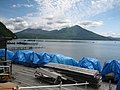
View of the Fuppushi


Web links
- Entry in the World Lake Database (English)
- Datasheet Shikotsu Caldera (Japanese)
- Tourist information (English)
Individual evidence
- ↑ Mikio Wakamatsu: 支 笏 湖 学 の す す め そ の 10. (PDF, 205 kB) Association of Hokkaidōs Geological Surveyors, accessed on September 2, 2018 (Japanese).
- ↑ Shikotsu. In: Global Volcanism Program ed = Smithsonian Institution . 2013, accessed on September 2, 2018 .
- ^ John Spacey: Lake Shikotsu. February 23, 2012, accessed September 2, 2018 .
- ↑ Shipping traffic on Shikotsu Lake. Retrieved September 2, 2018 (Japanese).
- ↑ 苫 小 牧 市 史, Volume 1, 1975 (History of the City of Tomakomai).