
Senmō main line
| Senmō main line | |||||||||||||||||||||||||||||||||||||||||||||||||||||||||||||||||||||||||||||||||||||||||||||||||||||||||||||||||||||||||||||||||||||||||||||||||||||||||||||||||||||||||||||||||||||||||||||||||||||||||||||||||||||||||||||||||||||
|---|---|---|---|---|---|---|---|---|---|---|---|---|---|---|---|---|---|---|---|---|---|---|---|---|---|---|---|---|---|---|---|---|---|---|---|---|---|---|---|---|---|---|---|---|---|---|---|---|---|---|---|---|---|---|---|---|---|---|---|---|---|---|---|---|---|---|---|---|---|---|---|---|---|---|---|---|---|---|---|---|---|---|---|---|---|---|---|---|---|---|---|---|---|---|---|---|---|---|---|---|---|---|---|---|---|---|---|---|---|---|---|---|---|---|---|---|---|---|---|---|---|---|---|---|---|---|---|---|---|---|---|---|---|---|---|---|---|---|---|---|---|---|---|---|---|---|---|---|---|---|---|---|---|---|---|---|---|---|---|---|---|---|---|---|---|---|---|---|---|---|---|---|---|---|---|---|---|---|---|---|---|---|---|---|---|---|---|---|---|---|---|---|---|---|---|---|---|---|---|---|---|---|---|---|---|---|---|---|---|---|---|---|---|---|---|---|---|---|---|---|---|---|---|---|---|---|---|---|---|
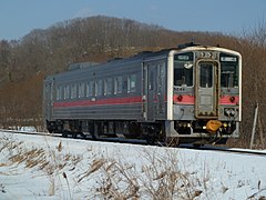
 Diesel multiple unit type KiHa 54 in Mashū
| |||||||||||||||||||||||||||||||||||||||||||||||||||||||||||||||||||||||||||||||||||||||||||||||||||||||||||||||||||||||||||||||||||||||||||||||||||||||||||||||||||||||||||||||||||||||||||||||||||||||||||||||||||||||||||||||||||||
 | |||||||||||||||||||||||||||||||||||||||||||||||||||||||||||||||||||||||||||||||||||||||||||||||||||||||||||||||||||||||||||||||||||||||||||||||||||||||||||||||||||||||||||||||||||||||||||||||||||||||||||||||||||||||||||||||||||||
| Route length: | 166.2 km | ||||||||||||||||||||||||||||||||||||||||||||||||||||||||||||||||||||||||||||||||||||||||||||||||||||||||||||||||||||||||||||||||||||||||||||||||||||||||||||||||||||||||||||||||||||||||||||||||||||||||||||||||||||||||||||||||||||
| Gauge : | 1067 mm ( cape track ) | ||||||||||||||||||||||||||||||||||||||||||||||||||||||||||||||||||||||||||||||||||||||||||||||||||||||||||||||||||||||||||||||||||||||||||||||||||||||||||||||||||||||||||||||||||||||||||||||||||||||||||||||||||||||||||||||||||||
| Maximum slope : | 25 ‰ | ||||||||||||||||||||||||||||||||||||||||||||||||||||||||||||||||||||||||||||||||||||||||||||||||||||||||||||||||||||||||||||||||||||||||||||||||||||||||||||||||||||||||||||||||||||||||||||||||||||||||||||||||||||||||||||||||||||
| Minimum radius : | 300 m | ||||||||||||||||||||||||||||||||||||||||||||||||||||||||||||||||||||||||||||||||||||||||||||||||||||||||||||||||||||||||||||||||||||||||||||||||||||||||||||||||||||||||||||||||||||||||||||||||||||||||||||||||||||||||||||||||||||
| Top speed: | 80 km / h | ||||||||||||||||||||||||||||||||||||||||||||||||||||||||||||||||||||||||||||||||||||||||||||||||||||||||||||||||||||||||||||||||||||||||||||||||||||||||||||||||||||||||||||||||||||||||||||||||||||||||||||||||||||||||||||||||||||
| Dual track : | No | ||||||||||||||||||||||||||||||||||||||||||||||||||||||||||||||||||||||||||||||||||||||||||||||||||||||||||||||||||||||||||||||||||||||||||||||||||||||||||||||||||||||||||||||||||||||||||||||||||||||||||||||||||||||||||||||||||||
| Society: | JR Hokkaidō | ||||||||||||||||||||||||||||||||||||||||||||||||||||||||||||||||||||||||||||||||||||||||||||||||||||||||||||||||||||||||||||||||||||||||||||||||||||||||||||||||||||||||||||||||||||||||||||||||||||||||||||||||||||||||||||||||||||
|
|||||||||||||||||||||||||||||||||||||||||||||||||||||||||||||||||||||||||||||||||||||||||||||||||||||||||||||||||||||||||||||||||||||||||||||||||||||||||||||||||||||||||||||||||||||||||||||||||||||||||||||||||||||||||||||||||||||
The Senmō main line ( Japanese 釧 網 本 線 , Senmō-honsen ) is a railway line on the Japanese island of Hokkaidō , which is operated by the Hokkaido Railway Company (JR Hokkaido). It runs in the east of the island between the cities of Kushiro and Abashiri . The name is derived from the Kanji characters of the two endpoints ( 釧路 , Kushiro or 網走 , Abashiri ). The route was built between 1924 and 1931.
description
The Senmō main line, laid in Cape Gauge (1067 mm), is 166.2 km long and opens up the sparsely populated east of the island. Along its entire length, it is single-track (apart from evasion ) and not electrified. In passenger traffic, 27 train stations and stops are served, freight traffic is not carried out. At the northern end point, Abashiri station , the Senmō main line is a direct continuation of the Sekihoku main line coming from Asahikawa . It initially follows the coast of the Sea of Okhotsk in an easterly direction to Shiretoko-Shari . There she turns south. The route then passes the foothills of the Shari-dake and Iō-zan volcanoes, Lake Tōro and the Kushiro moor. Finally, the southern endpoint Higashi-Kushiro is reached on the eastern outskirts of Kushiro , but all trains continue to run to Kushiro station .
Trains
Regional trains run the entire route from Abashiri to Kushiro and back four times a day . The Shiretoko express train also travels the entire route once a day . In addition, there are further regional train pairs on sections of the route at the edge of the day: once a day between Abashiri and Shiretoko-Shari , once a day between Abashiri and Midori and twice a day between Kushiro and Mashū. All trains are operated by one person.
Since the Senmō main line runs through scenic areas, JR Hokkaido offers various excursion trains with nostalgic rolling stock. During the Golden Week and in summer, the Kushiroshitsugen Norokko runs once or twice a day between Kushiro and Tōro, consisting of a JNR class DE10 diesel locomotive and up to five summer wagons . The same composition runs between Kushiro and Kawayu Onsen in autumn. In the months of January to March, the "Winter Moor Train" runs several times between Kushiro and Shibecha. It consists of the steam locomotive No. 171 of the JNR class C11 and five passenger carriages of the former state railway; one of the floats can be used for tea ceremonies .
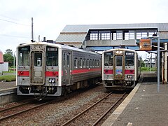
Trains crossing in Kiyosatochō station

The Senmō main line at Lake Tōro
Regional train at Tōya

Nostalgiezug Kushiroshitsugen Norokko


history
Four decades before the construction of the Senmō main line, there was a freight railway line in the area for a short time. The private company Kushiro Tetsudō ( 釧 路 鉄 道 ) opened in December 1887 a 41.8 km long cape-lane route from Shibecha to a sulfur mine at the foot of the Atosanobori volcano. It was in operation until August 1, 1896, when it had to be shut down due to a lack of profitability. The section of the Senmō main line between Shibecha and Mashū, opened 35 years later, uses the route of the former mine railway over a length of 17 km .
The Ministry of Railways built the Senmō main line in stages from both ends. The following sections went into operation from the north: from Abashiri to Kitahama (11.5 km) on November 15, 1924, from Kitahama to Shiretoko-Shari (25.8 km) on November 10, 1925 and from Shiretoko-Shari to Sattsuru ( 19.7 km) on November 14, 1929. These sections of the route were collectively known as the Abashiri Main Line ( 網 走 本 線 , Abashiri-honsen ). From the south, the route sections were opened as follows: from Higashi-Kushiro to Shibecha (45.0 km) on September 15, 1927, from Shibecha to Mashū (25.3 km) on August 15, 1929 and from Mashū to Kawayu-Onsen (15.9 km) on August 20, 1930. Together they formed the Senmō Line ( 釧 網 線 , Senmō-sen ).
The opening of the still missing middle section from Sattsuru via Midori to Kawayu-Onsen (22.8 km) took place on September 20, 1931, after which the entire route between Abashiri and Kushiro was referred to as the Senmō line. The route was given its current name on October 29, 1936. The last train pulled by a steam locomotive in regular service ran on July 21, 1974. As part of the privatization of the Japanese State Railways , the line became the property of the new company JR Hokkaido on April 1, 1987 . On April 1, 2002, JR Freight ceased all freight traffic.
In November 2016, JR Hokkaido announced an extensive rationalization program, which, among other things, affects the entire Senmō main line. The railway company wanted to persuade the neighboring communities to bear part of the operating and maintenance costs. Since it was foreseeable that the financially weak communities would not have been able to do so, the facility was threatened with closure. A commission convened by the prefectural government presented a report in March 2017 that highlighted possibilities for strengthening the transport network. Instead of looking at each individual route for itself, an overall view should be made instead. As a result, the shutdown could be avoided for the time being. Heavy rain and melted snow led to the washing of the tracks between Abashiri and Shiretoko-Shari on March 10, 2020. After a few days, however, train operations could be resumed.
List of train stations
| Surname | km | Connecting lines | location | place | |
|---|---|---|---|---|---|
| Senmō main line | |||||
| A69 | Abashiri ( 網 走 ) | 0.0 | Sekihoku main line | Coord. | Abashiri |
| B79 | Katsuradai ( 桂 台 ) | 1.4 | Coord. | ||
| B78 | Masuura ( 鱒 浦 ) | 6.2 | Coord. | ||
| B77 | Mokoto ( 藻 琴 ) | 8.7 | Coord. | ||
| B76 | Kitahama ( 北 浜 ) | 11.5 | Coord. | ||
| B75 | Genseikaen ( 原 生 花園 ) | 16.9 | Coord. | Koshimizu | |
| B74 | Hama-Koshimizu ( 浜 小 清水 ) | 20.1 | Coord. | ||
| B73 | Yamubetsu ( 止 別 ) | 25.8 | Coord. | ||
| B72 | Shiretoko-Shari ( 知 床 斜 里 ) | 37.3 | Coord. | Shari | |
| B71 | Naka-Shari ( 中 斜 里 ) | 41.9 | Coord. | ||
| B70 | Minami-Shari ( 南 斜 里 ) | 44.1 | Coord. | ||
| B69 | Kiyosatochō ( 清 里 町 ) | 49.2 | Coord. | Kiyosato | |
| B68 | Sattsuru ( 札 弦 ) | 57.0 | Coord. | ||
| B67 | Midori ( 緑 ) | 65.3 | Coord. | ||
| B66 | Kawayu Onsen ( 川 湯 温泉 ) | 79.8 | Coord. | Teshikaga | |
| B65 | Biruwa ( 美 留 和 ) | 87.0 | Coord. | ||
| B64 | Mashū ( 摩 周 ) | 95.7 | Coord. | ||
| B63 | Minami-Teshikaga ( 南 弟子 屈 ) | 103.9 | Coord. | ||
| B62 | Isobunnai ( 磯 分内 ) | 110.4 | Coord. | Shibecha | |
| B61 | Shibecha ( 標 茶 ) | 121.0 | Coord. | ||
| B60 | Gojikkoku ( 五十 石 ) | 129.5 | Coord. | ||
| B59 | Kayanuma ( 茅 沼 ) | 134.9 | Coord. | ||
| B58 | Tōro ( 塘路 ) | 141.9 | Coord. | ||
| B57 | Hosooka ( 細 岡 ) | 149.1 | Coord. | Kushiro-cho | |
| B56 | Kushiroshitsugen ( 釧 路 湿 原 ) | 151.5 | Coord. | ||
| B55 | Tōya ( 遠 矢 ) | 158.8 | Coord. | ||
| B54 | Higashi-Kushiro ( 東 釧 路 ) | 166.2 | Nemuro main line | Coord. | Kushiro |
| Nemuro main line | |||||
| K53 | Kushiro ( 釧 路 ) | 2.9 | Nemuro main line | Coord. | Kushiro |
Web links
Individual evidence
- ↑ く し ろ 湿 原 ノ ロ ッ コ . JR Hokkaido, 2017; Retrieved April 11, 2017 (Japanese).
- ↑ SL 冬 の 湿 原 号 . (No longer available online.) JR Hokkaido, 2017, archived from the original on January 8, 2017 ; Retrieved April 11, 2017 (Japanese). Info: The archive link was inserted automatically and has not yet been checked. Please check the original and archive link according to the instructions and then remove this notice.
- ↑ Keisuke Imao: 日本 鉄 道 旅行 地 図 帳 (Japan Rail Travel Atlas ) . tape 1 Hokkaidō. Shinchosha, Tokyo 2008, ISBN 978-4-10-790019-7 , pp. 43 .
- ↑ a b Kazuo Tanaka: 写真 で 見 る 北海道 の 鉄 道 (Hokkaidō's railroad in photos) . tape 1 . Hokkaidō Shinbunsha, Sapporo 2002, ISBN 978-4-89453-220-5 , pp. 110-111 .
- ↑ Satoru Sone: 週刊 歴 史 で め ぐ る 鉄 道 全 路線 国 鉄 ・ JR . tape 28 . Asahi Shimbunsha, Osaka 2010, p. 5-15 .
- ↑ JR Hokkaido says it can't maintain half of its railways. Japan Times , November 19, 2016, accessed April 11, 2017 .
- ↑ 幹線 交通 網 の 強化 提 言 、 道 検 討 会議 が 報告 書 案. Nikkei , March 29, 2017, accessed April 11, 2020 (Japanese).
- ↑ 北海道) 冠 水 で 釧 網 線 、 花 咲 線 が 運 休 少 な く と も 1 週 間. Asahi Shimbun , March 13, 2020, accessed April 11, 2020 (Japanese).
Current lines: Hokkaidō-Shinkansen | Chitose line | Furano line | Hakodate main line | Hidaka main line | Kaikyō Line | Muroran main line | Nemuro main line | Rumoi main line | Sasshō Line | Sekihoku main line | Sekishō Line | Senmō main line | Sōya main line
Released Lines: Chihoku Line | Esashi line
Disused Lines: Horonai Line | Kamisunagawa branch line | Matsumae line | Nayoro main line | Shibetsu line | Shinmei line | Tenpoku Line | Utashinai line