
Sekihoku main line
| Sekihoku main line | |||||||||||||||||||||||||||||||||||||||||||||||||||||||||||||||||||||||||||||||||||||||||||||||||||||||||||||||||||||||||||||||||||||||||||||||||||||||||||||||||||||||||||||||||||||||||||||||||||||||||||||||||||||||||||||||||||||||||||||||||||||||||||||||||||||||||||||||||||||||||||||||||||||||||||||||||||||||||||||||||||||||||||||||||||||||||||||||||||||
|---|---|---|---|---|---|---|---|---|---|---|---|---|---|---|---|---|---|---|---|---|---|---|---|---|---|---|---|---|---|---|---|---|---|---|---|---|---|---|---|---|---|---|---|---|---|---|---|---|---|---|---|---|---|---|---|---|---|---|---|---|---|---|---|---|---|---|---|---|---|---|---|---|---|---|---|---|---|---|---|---|---|---|---|---|---|---|---|---|---|---|---|---|---|---|---|---|---|---|---|---|---|---|---|---|---|---|---|---|---|---|---|---|---|---|---|---|---|---|---|---|---|---|---|---|---|---|---|---|---|---|---|---|---|---|---|---|---|---|---|---|---|---|---|---|---|---|---|---|---|---|---|---|---|---|---|---|---|---|---|---|---|---|---|---|---|---|---|---|---|---|---|---|---|---|---|---|---|---|---|---|---|---|---|---|---|---|---|---|---|---|---|---|---|---|---|---|---|---|---|---|---|---|---|---|---|---|---|---|---|---|---|---|---|---|---|---|---|---|---|---|---|---|---|---|---|---|---|---|---|---|---|---|---|---|---|---|---|---|---|---|---|---|---|---|---|---|---|---|---|---|---|---|---|---|---|---|---|---|---|---|---|---|---|---|---|---|---|---|---|---|---|---|---|---|---|---|---|---|---|---|---|---|---|---|---|---|---|---|---|---|---|---|---|---|---|---|---|---|---|---|---|---|---|---|---|---|---|---|---|---|---|---|---|---|---|---|---|---|---|---|---|---|---|---|---|---|---|---|---|---|---|---|---|---|---|---|---|---|---|---|---|---|---|---|---|---|---|---|---|---|---|---|---|---|---|---|---|
 “Okhotsk” diesel multiple unit type KiHa 183 in Abashiri
| |||||||||||||||||||||||||||||||||||||||||||||||||||||||||||||||||||||||||||||||||||||||||||||||||||||||||||||||||||||||||||||||||||||||||||||||||||||||||||||||||||||||||||||||||||||||||||||||||||||||||||||||||||||||||||||||||||||||||||||||||||||||||||||||||||||||||||||||||||||||||||||||||||||||||||||||||||||||||||||||||||||||||||||||||||||||||||||||||||||
 | |||||||||||||||||||||||||||||||||||||||||||||||||||||||||||||||||||||||||||||||||||||||||||||||||||||||||||||||||||||||||||||||||||||||||||||||||||||||||||||||||||||||||||||||||||||||||||||||||||||||||||||||||||||||||||||||||||||||||||||||||||||||||||||||||||||||||||||||||||||||||||||||||||||||||||||||||||||||||||||||||||||||||||||||||||||||||||||||||||||
| Route length: | 234.0 km | ||||||||||||||||||||||||||||||||||||||||||||||||||||||||||||||||||||||||||||||||||||||||||||||||||||||||||||||||||||||||||||||||||||||||||||||||||||||||||||||||||||||||||||||||||||||||||||||||||||||||||||||||||||||||||||||||||||||||||||||||||||||||||||||||||||||||||||||||||||||||||||||||||||||||||||||||||||||||||||||||||||||||||||||||||||||||||||||||||||
| Gauge : | 1067 mm ( cape track ) | ||||||||||||||||||||||||||||||||||||||||||||||||||||||||||||||||||||||||||||||||||||||||||||||||||||||||||||||||||||||||||||||||||||||||||||||||||||||||||||||||||||||||||||||||||||||||||||||||||||||||||||||||||||||||||||||||||||||||||||||||||||||||||||||||||||||||||||||||||||||||||||||||||||||||||||||||||||||||||||||||||||||||||||||||||||||||||||||||||||
| Top speed: | 95 km / h | ||||||||||||||||||||||||||||||||||||||||||||||||||||||||||||||||||||||||||||||||||||||||||||||||||||||||||||||||||||||||||||||||||||||||||||||||||||||||||||||||||||||||||||||||||||||||||||||||||||||||||||||||||||||||||||||||||||||||||||||||||||||||||||||||||||||||||||||||||||||||||||||||||||||||||||||||||||||||||||||||||||||||||||||||||||||||||||||||||||
| Dual track : | No | ||||||||||||||||||||||||||||||||||||||||||||||||||||||||||||||||||||||||||||||||||||||||||||||||||||||||||||||||||||||||||||||||||||||||||||||||||||||||||||||||||||||||||||||||||||||||||||||||||||||||||||||||||||||||||||||||||||||||||||||||||||||||||||||||||||||||||||||||||||||||||||||||||||||||||||||||||||||||||||||||||||||||||||||||||||||||||||||||||||
| Society: | JR Hokkaidō | ||||||||||||||||||||||||||||||||||||||||||||||||||||||||||||||||||||||||||||||||||||||||||||||||||||||||||||||||||||||||||||||||||||||||||||||||||||||||||||||||||||||||||||||||||||||||||||||||||||||||||||||||||||||||||||||||||||||||||||||||||||||||||||||||||||||||||||||||||||||||||||||||||||||||||||||||||||||||||||||||||||||||||||||||||||||||||||||||||||
|
|||||||||||||||||||||||||||||||||||||||||||||||||||||||||||||||||||||||||||||||||||||||||||||||||||||||||||||||||||||||||||||||||||||||||||||||||||||||||||||||||||||||||||||||||||||||||||||||||||||||||||||||||||||||||||||||||||||||||||||||||||||||||||||||||||||||||||||||||||||||||||||||||||||||||||||||||||||||||||||||||||||||||||||||||||||||||||||||||||||
The Sekihoku Main Line ( Japanese 石 北 本 線 , Sekihoku-honsen ) is a railway line on the Japanese island of Hokkaidō , operated by the Hokkaido Railway Company (JR Hokkaido). It runs from Asahikawa via Kitami to Abashiri . The name is derived from the Kanji characters of the historical provinces of Ishikari ( 石狩 国 ) and Kitami ( 北見 国 ) passed through . The route was built between 1912 and 1932.
description
The main Sekihoku line laid in Cape Gauge (1067 mm) is 234.0 km long and opens up the northeast of the island. Along its entire length, it is single-track (apart from evasion ) and not electrified. 36 train stations and stops are served in passenger traffic, freight traffic is carried out between Asahikawa and Kitami.
In Shin-Asahikawa , the Sekihoku main line branches off from the Sōya main line towards the east. It initially follows the upper reaches of the Ishikari River to Kamikawa . The main ridge of the Kitami Mountains is crossed under the 4329 m long Ishikata tunnel, near the Chitokaniushi mountain. Following the Yūbetsu River , Engaru is reached. Since this station can only be approached from one side, all trains have to turn around and continue in the opposite direction. After the Jōmon tunnel, the route continues via Kitami to Abashiri on the coast of the Sea of Okhotsk . There it goes into the Senmō main line .
Trains
For long-distance services from Sapporo via Asahikawa to Abashiri , JR Hokkaido offers four pairs of express trains a day . These Okhotsk express trains (named after the Sea of Okhotsk ) need around five and a half hours for the entire route, between Asahikawa and Abashiri just under four hours. They are made up of KiHa 183 diesel multiple units. The Kitami express train runs once a day from Asahikawa to Kitami and back.
As for local transportation, the main Sekihoku line is divided into three sections depending on the population density. A regional train runs between Asahikawa and Kamikawa every one to two hours . In the sparsely populated mountain region between Kamikawa and Engaru , only one regional train per day is offered. Regional trains run roughly every two to three hours between Engaru and Abashiri.

Engaru Station (2004)

Freight train between Kanehana and Ikutahara (2010)
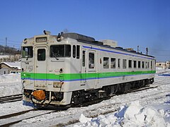
Regional train in Abashiri (2012)

Express train in Memambetsu (2009)


history
The Sekihoku main line consists of three sections that were built by the Ministry of Railways to open up the northeast of the island of Hokkaidō from different directions. The section between Abashiri and Kitami originated as part of the main Abashiri line ( 網 走 本 線 , Abashiri-honsen ) coming from the south , which was later referred to as the Chihoku line ( 池 北 線 , Chihoku-sen ) and the Furusato-ginga line . The section between Kitami and Engaru was originally the Yūbetsu Line (湧 別 線, Yūbetsu-sen ), which merged into the Nayoro Main Line ( 名 寄 本 線 , Nayoro-honsen ) to the northwest. After building a shortcut between Asahikawa and Engaru, the three sections were combined to form today's Sekihoku main line.
From Ikeda , the Abashiri main line reached Nokkeushi station (later called Kitami) on September 25, 1911. The first section of the future Sekihoku main line opened the Railway Authority (the forerunner of the Railway Ministry ) on October 5, 1912 between Nokkeushi and Abashiri. The Yūbetsu line from Nokkeushi to Rubeshibe opened on November 18 of the same year. For the further course of the route north of Rubeshibe, the railway authority initially decided on the narrow gauge of 762 mm. The first section of this Yūbetsu- narrow-gauge railway line ( 湧別軽便線 , Yubetsu-keibensen ) between Rubeshibe and Yasukuni went on 5 October 1914 in operation, followed by the section Yasukuni Engaru on 1 November 1915. By Umspurung on Cape gauge (1,067 mm) , which was completed on November 7, 1916, the small railway went completely in the rest of the Yūbetsu line.
From 1921 Engaru could also be reached via the Nayoro main line. Nevertheless, travelers had to take long detours to get to Abashiri, be it via Kushiro or Nayoro . At the beginning of the 1920s, the Ministry of Railways began building a direct connection between Asahikawa and Engaru, but for this purpose the Kitami Mountains had to be overcome. The Sekihokusai Line ( 石 北 西 線 , Sekihokusai-sen ) was advanced from the west . The first section from Shin-Asahikawa to Aibetsu went into operation on November 4, 1922, followed by the section to Kamikawa on November 15, 1923 . Finally, the Sekihokusai line gave on 20 November 1929 to the station Nakakoshi west of Kitami Pass (Only as since 2001 Ausweiche used).
From the east the Ministry of Railways built the Sekihokutō Line ( 石 北 東線 , Sekihokutō-sen ). The opening of the section between Engaru and Maruseppu took place on October 10, 1927. The town of Shirataki, east of the Kitami Pass, was linked on August 12, 1929. The 25 km long mountain railway section with the Ishikata tunnel as the centerpiece was still outstanding. When it went into operation on October 1, 1932, the line was continuously passable. On the same day, the Sekihokusai Line, the Sekihokutō Line and the Yūbetsu Line received the new common name Sekihoku Line ( 石 北 線 , Sekihoku-sen ).

The Japanese State Railways , responsible from 1949, began using rail buses in regional traffic on August 20, 1955 . Since April 1, 1961, the route has been known as the Sekihoku Main Line. The last express train in Japan pulled by steam locomotives ran on December 24, 1971, and on May 31, 1975, steam operations ended completely. As part of the privatization of the state railways on April 1, 1987, the line went into the possession of the new company JR Hokkaido , while JR Freight took over the freight traffic. The new owner streamlined operations, for example by introducing one-man operation and closing various train stations.
On March 1, 2007, a regional train crashed into a truck at a level crossing between Hiushinai and Bihoro and derailed; the accident left 51 injured. In November 2016, JR Hokkaido announced an extensive streamlining program that, among other things, affects the entire main Sekihoku line. The railway company wants to persuade the neighboring communities to bear part of the operating and maintenance costs. Should no agreement be reached by 2019, shutdown would also be conceivable.
List of train stations
| Surname | km | Connecting lines | location | place | |
|---|---|---|---|---|---|
| Sōya main line | |||||
| A28 | Asahikawa ( 旭川 ) | −3.7 |
Hakodate main line Furano line |
Coord. | Asahikawa |
| A29 | Asahikawa-Yojō ( 旭川 四条 ) | −1.9 | Coord. | ||
| Sekihoku main line | |||||
| A30 | Shin-Asahikawa ( 新 旭川 ) | 0.0 | Sōya main line | Coord. | Asahikawa |
| A31 | Minami-Nagayama ( 南 永 山 ) | 2.5 | Coord. | ||
| A32 | Higashi-Asahikawa ( 東 旭川 ) | 5.2 | Coord. | ||
| A33 | Kita-Hinode ( 北 日 ノ 出 ) | 7.3 | Coord. | ||
| A34 | Sakuraoka ( 桜 岡 ) | 10.2 | Coord. | ||
| A35 | Tōma ( 当 麻 ) | 13.9 | Coord. | Toma | |
| A36 | Shogunzan ( 将軍 山 ) | 17.4 | Coord. | ||
| A37 | Ikaushi ( 伊 香 牛 ) | 19.5 | Coord. | ||
| A38 | Aibetsu ( 愛 別 ) | 25.9 | Coord. | Aibetsu | |
| A39 | Naka-Aibetsu ( 中 愛 別 ) | 32.0 | Coord. | ||
| A40 | Aizan ( 愛 山 ) | 36.0 | Coord. | ||
| A41 | Antaroma ( 安 足 間 ) | 38.0 | Coord. | ||
| A42 | Tōun ( 東 雲 ) | 40.4 | Coord. | Kamikawa | |
| A43 | Kamikawa ( 上 川 ) | 44.9 | Coord. | ||
| A45 | Shirataki ( 白 滝 ) | 82.2 | Coord. | Engaru | |
| A48 | Maruseppu ( 丸 瀬 布 ) | 101.9 | Coord. | ||
| A49 | Setose ( 瀬 戸 瀬 ) | 109.7 | Coord. | ||
| A50 | Engaru ( 遠 軽 ) | 120.8 | Coord. | ||
| A51 | Yasukuni ( 安 国 ) | 128.8 | Coord. | ||
| A52 | Ikuno ( 生 野 ) | 132.7 | Coord. | ||
| A53 | Ikutahara ( 生 田原 ) | 137.7 | Coord. | ||
| A55 | Nishi-Rubeshibe ( 西 留 辺 蘂 ) | 156.2 | Coord. | Kitami | |
| A56 | Rubeshibe ( 留 辺 蘂 ) | 158.2 | Coord. | ||
| A57 | Ainonai ( 相 内 ) | 169.1 | Coord. | ||
| A58 | Higashi-Ainonai ( 東 相 内 ) | 173.7 | Coord. | ||
| A59 | Nishi Kitami ( 西北 見 ) | 176.3 | Coord. | ||
| A60 | Kitami ( 北 見 ) | 181.0 | Coord. | ||
| A61 | Hakuyō ( 柏 陽 ) | 183.7 | Coord. | ||
| A62 | Itoshino ( 愛 し 野 ) | 185.9 | Coord. | ||
| A63 | Tanno ( 端 野 ) | 187.3 | Coord. | ||
| A64 | Hiushinai ( 緋 牛 内 ) | 194.6 | Coord. | ||
| A65 | Bihoro ( 美 幌 ) | 206.1 | Coord. | Bihoro | |
| A66 | Nishi-Memambetsu ( 西 女 満 別 ) | 213.1 | Coord. | Ōzora | |
| A67 | Memambetsu ( 女 満 別 ) | 218.1 | Coord. | ||
| A68 | Yobito ( 呼 人 ) | 225.9 | Coord. | Abashiri | |
| A69 | Abashiri ( 網 走 ) | 234.0 | Senmō main line | Coord. | |
Web links
Individual evidence
- ↑ Kazuo Tanaka: 写真 で 見 る 北海道 の 鉄 道 (Hokkaidō's railroad in photos) . tape 1 . Hokkaidō Shinbunsha, Sapporo 2002, ISBN 978-4-89453-220-5 , pp. 236-237 .
- ↑ a b c d Tanaka: 写真 で 見 る 北海道 の 鉄 道 , pp. 104–105.
- ↑ a b c Tanaka: 写真 で 見 る 北海道 の 鉄 道 , pp. 100–101.
- ↑ 鉄 道 事故 の 概要 . Japan Road Safety Commission, January 25, 2008, archived from the original on August 14, 2015 ; Retrieved April 8, 2017 (Japanese).
- ↑ JR Hokkaido says it can't maintain half of its railways. The Japan Times , November 19, 2016, accessed April 8, 2017 .
Current lines: Hokkaidō-Shinkansen | Chitose line | Furano line | Hakodate main line | Hidaka main line | Kaikyō Line | Muroran main line | Nemuro main line | Rumoi main line | Sasshō Line | Sekihoku main line | Sekishō Line | Senmō main line | Sōya main line
Released Lines: Chihoku Line | Esashi line
Disused Lines: Horonai Line | Kamisunagawa branch line | Matsumae line | Nayoro main line | Shibetsu line | Shinmei line | Tenpoku Line | Utashinai line