
Yūbari Railway Line
| Yūbari Railway Line | |||||||||||||||||||||||||||||||||||||||||||||||||||||||||||||||||||||||||||||||||||||||||||||||||||||||||||||||||||||||||||||||||||||||||||||||||||||||||||||||||||||||||||||||||||||||||||||||||||||||||||||||||
|---|---|---|---|---|---|---|---|---|---|---|---|---|---|---|---|---|---|---|---|---|---|---|---|---|---|---|---|---|---|---|---|---|---|---|---|---|---|---|---|---|---|---|---|---|---|---|---|---|---|---|---|---|---|---|---|---|---|---|---|---|---|---|---|---|---|---|---|---|---|---|---|---|---|---|---|---|---|---|---|---|---|---|---|---|---|---|---|---|---|---|---|---|---|---|---|---|---|---|---|---|---|---|---|---|---|---|---|---|---|---|---|---|---|---|---|---|---|---|---|---|---|---|---|---|---|---|---|---|---|---|---|---|---|---|---|---|---|---|---|---|---|---|---|---|---|---|---|---|---|---|---|---|---|---|---|---|---|---|---|---|---|---|---|---|---|---|---|---|---|---|---|---|---|---|---|---|---|---|---|---|---|---|---|---|---|---|---|---|---|---|---|---|---|---|---|---|---|---|---|---|---|---|---|---|---|---|---|---|---|
| Route length: | 53.2 km | ||||||||||||||||||||||||||||||||||||||||||||||||||||||||||||||||||||||||||||||||||||||||||||||||||||||||||||||||||||||||||||||||||||||||||||||||||||||||||||||||||||||||||||||||||||||||||||||||||||||||||||||||
| Gauge : | 1067 mm ( cape track ) | ||||||||||||||||||||||||||||||||||||||||||||||||||||||||||||||||||||||||||||||||||||||||||||||||||||||||||||||||||||||||||||||||||||||||||||||||||||||||||||||||||||||||||||||||||||||||||||||||||||||||||||||||
| Maximum slope : | 22.73 ‰ | ||||||||||||||||||||||||||||||||||||||||||||||||||||||||||||||||||||||||||||||||||||||||||||||||||||||||||||||||||||||||||||||||||||||||||||||||||||||||||||||||||||||||||||||||||||||||||||||||||||||||||||||||
| Minimum radius : | 181 m | ||||||||||||||||||||||||||||||||||||||||||||||||||||||||||||||||||||||||||||||||||||||||||||||||||||||||||||||||||||||||||||||||||||||||||||||||||||||||||||||||||||||||||||||||||||||||||||||||||||||||||||||||
| Dual track : | No | ||||||||||||||||||||||||||||||||||||||||||||||||||||||||||||||||||||||||||||||||||||||||||||||||||||||||||||||||||||||||||||||||||||||||||||||||||||||||||||||||||||||||||||||||||||||||||||||||||||||||||||||||
|
|||||||||||||||||||||||||||||||||||||||||||||||||||||||||||||||||||||||||||||||||||||||||||||||||||||||||||||||||||||||||||||||||||||||||||||||||||||||||||||||||||||||||||||||||||||||||||||||||||||||||||||||||
The Yūbari Railway Line ( Japanese 夕 張 鉄 道 線 ; Yūbari-tetsudō-sen ) was a railway line on the Japanese island of Hokkaidō . It led from Ebetsu (east of Sapporo ) via Kuriyama to Yūbari and was owned by the private railway company Yūbari Tetsudō . It was in operation from 1926 to 1975.
description
The route was 53.2 km long, laid in Cape gauge (1067 mm), single-track and not electrified. It began at Nopporo station near Sapporo , where it branched off from the Hakodate main line. First it led through flat, intensively agricultural area to the eastern edge of the Ishikari plain to Kuriyama station . There it crossed the Muroran main line . Then the route continued through the lower Ahoro valley. She reached the upper Yūbari Valley through three short tunnels and two switchbacks . Between the Yūseimae and Yūbari-honchō stations, it ran largely parallel to the Sekishō line .
Nishikizawa station was the only one in Japan between two switchbacks. He developed a small amusement park operated by the railway company (錦 沢 遊 園地, nishikizawa yūenchi), which has been left to decay since it was closed in 1970. There were connections to several mine railways ; the longest of these lines connected Shin-Futamata station with the Tsunoda coal mine over a distance of 4.7 km. Most of the route between Nopporo and Kuriyama has been converted into a road. This is largely reserved for agricultural vehicles. A short section of the route in the area around Heiwa and Nishikizawa is now a cycle path .
history
The company Hokkaidō Tankō Kisen ( 北海道 炭 礦 汽船 , "Hokkaidō Mine and Steamship Company"), which had emerged from the earlier mining and railway company Hokkaidō Tankō Tetsudō , operated a short connecting line from its coal mine in Yūbari to the state since 1909 Railway line towards Muroran and Otaru (later Sekishō line ). In order to no longer be dependent on the Ministry of Railways , Hokkaidō Tankō Kisen wanted to build its own railway line. For this purpose, the subsidiary Yūbari Tetsudō ( 夕 張 鉄 道 ) was founded on January 24, 1924 . Construction work began on September 1 of the same year.
On October 14, 1926, the opening of the 30.2 km long section between Yūbari-honchō and Kuriyama station took place , while the connection line was shut down on the same day. The construction of the line west of Kuriyama began in August 1929. The Ebetsu station was specified in the license application as the western terminus, but three months before construction began, the railway company decided in favor of the Nopporo station instead , as otherwise the line would have led over poorly stable peatland . With the opening of the 23.0 km long Kuriyama – Nopporo section, the route was completed.
The Yūbari railway line was especially important for the transport of coal and volcanic ash . Passenger traffic was also important, especially since the Yūbari railway line was by far the shortest connection between Yūbari and Sapporo . The highest number of passengers was recorded in the 1959 fiscal year (2.6 million). Electrification of the railway line was planned at the end of the 1940s , but the railway company finally decided on diesel multiple units . The conversion took place in 1952, but steam locomotives remained in service for freight traffic even afterwards. From 1961 to 1967 express trains ran between Yūbari and Nopporo. After taking over the Yūbari Bus company on October 1, 1963, the railway company also began operating bus routes.
Increasing motorized individual traffic, the closure of most mines and the associated decline in population resulted in a steadily decreasing volume of traffic from the 1960s onwards. The section between Heiwa and Yūbari-honchō was closed on November 15, 1971. Yūbari Tetsudō ceased passenger transport on April 1, 1974 and became a pure bus company. The parent company Hokkaidō Tankō Kisen operated the freight traffic for a year and finally put the remaining Heiwa – Nopporo line on April 1, 1975.
photos

Track construction (1925)

Freight train at the Bansui stop (1967)
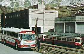
Yūbari-honchō Station in the early 1970s
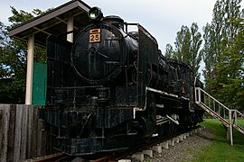
Steam locomotive No. 25


List of train stations
| Surname | km | Connecting lines | location | place |
|---|---|---|---|---|
| Nopporo ( 野 幌 ) | 0.0 | Hakodate main line | Coord. | Ebetsu |
| Hokkaikōkimae ( 北海 鋼 機 前 ) | 0.8 | Coord. | ||
| Kami-Ebetsu ( 上 江 別 ) | 2.4 | Coord. | ||
| Shimonotsuki ( 下 の 月 ) | 6.0 | Coord. | ||
| Bansui ( 晩 翠 ) | 8.6 | Coord. | Namporo | |
| Namporo ( 南 幌 ) | 12.2 | Coord. | ||
| Futaba ( 双 葉 ) | 15.6 | Coord. | Naganuma | |
| Kita-Naganuma ( 北 長 沼 ) | 18.1 | Coord. | ||
| Chuō-Nōshimae ( 中央 農 試 前 ) | 20.9 | Coord. | ||
| Kuriyama ( 栗 山 ) | 23.0 | Muroran main line | Coord. | Kuriyama |
| Kakuta ( 角 田 ) | 27.4 | Coord. | ||
| Tsugitate ( 継 立 ) | 32.1 | Coord. | ||
| Shin-Futamata ( 新 二 岐 ) | 35.7 | Coord. | ||
| Nishikizawa ( 錦 沢 ) | 43.3 | Coord. | Yūbari | |
| Heiwa ( 平和 ) | 47.4 | Coord. | ||
| Kougyōshomae ( 礦業 所 前 ) | 48.2 | Coord. | ||
| Yūseimae ( 夕 製 前 ) | 48.8 | Coord. | ||
| Wakana ( 若 菜 ) | 49.1 | Coord. | ||
| Eirinshomae ( 営 林 署 前 ) | 50.1 | Coord. | ||
| Shikanotani ( 鹿 ノ 谷 ) | 51.1 | Yūbari line | Coord. | |
| Suehiro ( 末 広 ) | 52.0 | Coord. | ||
| Yūbari-honchō ( 夕 張 本 町 ) | 53.2 | Coord. |
literature
- Yoneo Koguma: 夕 張 鉄 道 (Yūbari Tetsudō) . In: 鉄 道 ピ ク ト リ ア ル (Tetsudō Pictorial) . No. 212 . Tetsudō tosho kankōkai, Tokyo July 1968, p. 4-5, 11-26 (Japanese).
Web links
- Website of the Yūbari Tetsudō (Japanese)
Individual evidence
- ↑ Hideki Egami: 錦 沢. I love Switchback, 2010, accessed July 8, 2017 (Japanese).
- ↑ 錦 沢 遊 園地【消 え た 楽 園 2】 夕 張 錦 沢 遊 園地. Viva Hokkaido, June 17, 2014, accessed July 8, 2017 (Japanese).