
Marchampt
| Marchampt | ||
|---|---|---|
|
||
| region | Auvergne-Rhône-Alpes | |
| Department | Rhône | |
| Arrondissement | Villefranche-sur-Saône | |
| Canton | Belleville | |
| Community association | Saone-Beaujolais | |
| Coordinates | 46 ° 7 ' N , 4 ° 34' E | |
| height | 318-883 m | |
| surface | 17.74 km 2 | |
| Residents | 462 (January 1, 2017) | |
| Population density | 26 inhabitants / km 2 | |
| Post Code | 69430 | |
| INSEE code | 69124 | |
 View of the roofs of Marchampt |
||

Marchampt is a French municipality with 462 inhabitants (as of January 1 2017) in the department of Rhône in the region of Auvergne Rhône-Alpes . It belongs to the arrondissement of Villefranche-sur-Saône and the canton of Belleville (until 2015: canton of Beaujeu ).
geography
Marchampt is about 17 kilometers northwest of Villefranche-sur-Saône . The small river Petite Grosne has its source here . Marchampt is surrounded by the neighboring communities of Beaujeu in the north, Quincié-en-Beaujolais in the east, Le Perréon in the south, Claveisolles in the west and Saint-Didier-sur-Beaujeu in the north-west.
Population development
| 1962 | 1968 | 1975 | 1982 | 1990 | 1999 | 2006 | 2013 | |
|---|---|---|---|---|---|---|---|---|
| 413 | 317 | 286 | 295 | 303 | 363 | 426 | 441 | |
| Source: Cassini and INSEE | ||||||||
Attractions
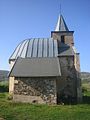
- Church from 1840
- Notre-Dame-l'Auxiliatrice chapel in Cremasson
- Saint-Emillian Chapel from 1577 in Varennes
- Les Roches Castle, built in 1860
- Varennes Castle
Notre-Dame-l'Auxiliatrice chapel

Saint-Emillian Chapel

Les Roches Castle


Web links
Commons : Marchampt - collection of images, videos and audio files