
Lacenas
| Lacenas | ||
|---|---|---|
|
||
| region | Auvergne-Rhône-Alpes | |
| Department | Rhône | |
| Arrondissement | Villefranche-sur-Saône | |
| Canton | Gleizé | |
| Community association | Villefranche Beaujolais Saône | |
| Coordinates | 46 ° 0 ′ N , 4 ° 39 ′ E | |
| height | 229-371 m | |
| surface | 3.36 km 2 | |
| Residents | 972 (January 1, 2017) | |
| Population density | 289 inhabitants / km 2 | |
| Post Code | 69460 | |
| INSEE code | 69105 | |

Lacenas is a French municipality with 972 inhabitants (as of January 1 2017) in the department of Rhône in the region of Auvergne Rhône-Alpes . The municipality belongs to the arrondissement of Villefranche-sur-Saône and the canton of Gleizé .
geography
Lacenas is located around six kilometers west of Villefranche-sur-Saône in the Bourgogne wine region . Lacenas is surrounded by the neighboring municipalities of Denicé in the north, Gleizé in the east, Porte des Pierres Dorées with Liergues in the south and southeast, Jarnioux in the south and southwest and Cogny in the west.
Population development
| year | 1962 | 1968 | 1975 | 1982 | 1990 | 1999 | 2006 | 2013 |
| Residents | 474 | 443 | 455 | 471 | 714 | 852 | 850 | 923 |
| Source: Cassini and INSEE | ||||||||
Attractions
- Former church of Notre-Dame-du-Son in the village of Saint-Paul from the 12th century, monument historique since 1981
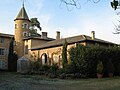
- Le Sou Castle
- Montauzan Castle
- Bionnay Castle

Notre-Dame-de-Son church in Saint-Paul

Le Sou Castle
Montauzan Castle

Bionnay Castle


Personalities
- Gaël Morel (* 1972), director
Web links
Commons : Lacenas - collection of images, videos and audio files