
Courzieu
| Courzieu | ||
|---|---|---|

|
|
|
| region | Auvergne-Rhône-Alpes | |
| Department | Rhône | |
| Arrondissement | Villefranche-sur-Saône | |
| Canton | L'Arbresle | |
| Community association | Pays de L'Arbresle | |
| Coordinates | 45 ° 45 ′ N , 4 ° 34 ′ E | |
| height | 269-908 m | |
| surface | 27 km 2 | |
| Residents | 1,118 (January 1, 2017) | |
| Population density | 41 inhabitants / km 2 | |
| Post Code | 69690 | |
| INSEE code | 69067 | |
 View of the village with the Saint Didier church |
||

Courzieu ( pronunciation : [ kuʀzjø ]) is a French commune in the department of Rhône in the region of Auvergne Rhône-Alpes . The residents call themselves Courzerois ( pronunciation : [ kuʀzəʀwa ]).
geography
The municipality is located on the old Via Agrippa road ( Saintes - Lyon , also known as the " Aquitaine " road) and leads from Feurs (35 km to the west) over the Malval pass ( 732 m ) to the center of Lyon (35 km to the east).
Adjacent communities
| Bessenay | Chevinay | Pollionnay |
| Brussieu |
|
Vaugneray |
| Saint-Genis-l'Argentière | Montromant | Yzeron |
Water network
- The Brévenne river limits the municipality to the northwest;
- The Rossard is 6.7 km long and flows into the Brévenne;
- The Goutte du Soupa is 3.9 km long and flows into the Brévenne;
- The Glavaroux is 4.9 km and flows into the Brévenne
- The Goutte du Soupat is on the list of nature zones of interest for ecology, fauna and flora on the Rhône .
Toponomics
Courzieu derives its name from the Gallic name Curisius .
history

A document dated August 27, 925 states that the then Archbishop of Lyon, Rémy II and Count Guillaume, agreed to a donation to the Abbaye de Savigny monastery by the landlord Adelfred, his wife Richborge and their son Sévère. It was about four horse riding and vineyards as well as the organization of the annual festival at the church of Courzieu on the anniversary of Saint-Martin.
During the period between the two world wars , the engineer Joseph Aubert (1876–1911), a member of the association of former students at the École Centrale de Lyon , organized the mining of sandstone near Courzieu, which was mainly used for road construction in the Lyon area , before bitumen was used. Joseph Aubert was elected mayor of the town in May 1935; he kept the office until his death. During his tenure he took care of the electrification of the village and the local road network; he started the installations for the drinking water supply, but the project was interrupted by the beginning of the Second World War.
Heraldry
|
|
Blazon : “left side: red and white striped; right side: on a blue background a golden falcon on a golden branch " |
Politics and administration
| from | to | Surname | Political party | title |
|---|---|---|---|---|
| 2001 | 2014 | Jean Lardellier | ||
| 2014 | in office | Jean-Bernard Cherblanc |
The municipality is part of the Communauté de communes du Pays de L'Arbresle .
Demographics
On January 1, 2017, the municipality had 1,118 inhabitants. The development of the population can be traced back to 1793 on the basis of surveys. From the 21st century onwards, an actual census is only carried out every 5 years in municipalities with fewer than 10,000 inhabitants; in the other municipalities an estimate is carried out every year.
Attractions
- Oppidum du Châtelard : Oppidum was occupied in the Latène period during the Gallo-Roman period. It has beenrecognizedas a monument historique since 1989.
- Parc animalier The zoo is educational and open to participation.
- The Saint-Didier church was built in 1896; it replaces the old church, which was too small and stands on the ruins of the former castle.
- The bell tower of the church has a carillon with 8 bells, one of which dates from 1726, rings for church services and is recognized as a "Monument historique"
- During the season, a historic standard-gauge train connects L'Arbresle and Sainte-Foy-l'Argentière with a stop at Courzieu-Brussieu station in the hamlet of Giraudière. The rolling stock consists of restored locomotives and wagons.
- The Aqueduc de la Brévenne , part of the aqueduct that supplied Lugdunum (today's Lyon ) with water.
- Impressions from Courzieu

Saint Didier Church
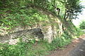
Remains of the Aqueduc de la Brévenne

Well in the hamlet of Lafont

The monastery drawn by Joannès Drevet (1854–1940).

old bridge by the hotel, drawn by J. Drevet.


annotation
- ↑ here the region around Vaugneray The site is only available in French and gives a detailed (official) description of the Rhône-Alpes region.
Web links
Individual evidence
- ↑ Height according to the official directory
- ↑ Plan cadastral de la commune
- ↑ Le Rossand at SANDRE (French)
- ↑ Goutte du Soupa at SANDRE (French)
- ↑ Le Glavaroux at SANDRE (French)
- ^ Zones naturelles d'intérêt écologique, faunistique et floristique
- ↑ Les noms de lieux dans la région lyonnaise aux époques celtique et gallo-romaine , p. 33. Gallica
- ↑ Auguste Bernard: Cartulaire de l'Abbaye de Savinighy : charte n ° 7, t. 1, Paris 1853, p. 11
- ↑ cf. List of Archbishops of Lyon
- ^ Biography of Joseph Aubert (PDF) in the magazine Technica from 1941, page 38
- ^ Oppidum du Châtelard in the list of Monuments historiques
- ↑ Official site accessed on April 3, 2015
- ↑ cf. the different zoo types
- ^ Parish of Courzieu
- ↑ Monuments historiques