
Chénelette
| Chénelette | ||
|---|---|---|
.svg)
|
|
|
| region | Auvergne-Rhône-Alpes | |
| Department | Rhône | |
| Arrondissement | Villefranche-sur-Saône | |
| Canton | Thizy-les-Bourgs | |
| Community association | Ouest Rhodania | |
| Coordinates | 46 ° 10 ′ N , 4 ° 30 ′ E | |
| height | 552-940 m | |
| surface | 11.02 km 2 | |
| Residents | 321 (January 1, 2017) | |
| Population density | 29 inhabitants / km 2 | |
| Post Code | 69430 | |
| INSEE code | 69054 | |

Chénelette is a French commune of 321 inhabitants (1 January 2017) in the department of Rhône in the region of Auvergne Rhône-Alpes .
geography
Chénelette is a small village in the north-west of the Rhône department. The place is about 60 kilometers north-northwest of Lyon between Roanne and Mâcon . The surrounding landscape is characterized by the mountainous forests and pastures of the Massif Central .
history
Chénelette has its roots in the Middle Ages when a castle was built on the summit of Mont Tourvéon in the 13th century. The ruins of the castle are still visible today.
Population development:
| 1962 | 1968 | 1975 | 1982 | 1990 | 1999 | 2006 |
|---|---|---|---|---|---|---|
| 320 | 293 | 277 | 270 | 284 | 315 | 324 |
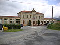
town hall

church
_mairie-%C3%A9cole.JPG)
_%C3%A9glise.JPG)
Web links
Commons : Chénelette - collection of images, videos and audio files