
Saint-Igny-de-Vers
| Saint-Igny-de-Vers | ||
|---|---|---|

|
|
|
| region | Auvergne-Rhône-Alpes | |
| Department | Rhône | |
| Arrondissement | Villefranche-sur-Saône | |
| Canton | Thizy-les-Bourgs | |
| Community association | Saone-Beaujolais | |
| Coordinates | 46 ° 14 ' N , 4 ° 26' E | |
| height | 407-943 m | |
| surface | 27.35 km 2 | |
| Residents | 582 (January 1, 2017) | |
| Population density | 21 inhabitants / km 2 | |
| Post Code | 69790 | |
| INSEE code | 69209 | |
 Town hall (Mairie) of Saint-Igny-de-Vers |
||

Saint-Igny-de-Vers is a French municipality with 582 inhabitants (as of January 1 2017) in the department of Rhône in the region of Auvergne Rhône-Alpes . It belongs to the arrondissement of Villefranche-sur-Saône and the canton of Thizy-les-Bourgs (until 2015: canton of Monsols ). The inhabitants are called Saint-Ignons .
geography
Saint-Igny-de-Vers is located about 61 kilometers north-northwest of Lyon and about 35 kilometers north-northwest of Villefranche-sur-Saône . Saint-Igny-de-Vers is surrounded by the neighboring communities of Aigueperse in the north and northwest, Saint-Bonnet-des-Bruyères in the north and northeast, Deux-Grosnes with Monsols in the east, Propières in the south and west and Saint-Racho in the west and Northwest.
Population development
| year | 1962 | 1968 | 1975 | 1982 | 1990 | 1999 | 2006 | 2013 |
| Residents | 828 | 759 | 729 | 598 | 503 | 553 | 592 | 600 |
| Source: Cassini and INSEE | ||||||||
Attractions
- Saint-Jean-Baptiste church
- Notre-Dame chapel
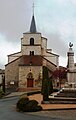
Saint-Jean-Baptiste church and monument to the fallen

Notre-Dame chapel

