
Saint-Vérand (Rhône)
| Saint-Vérand | ||
|---|---|---|
.svg)
|
|
|
| region | Auvergne-Rhône-Alpes | |
| Department | Rhône | |
| Arrondissement | Villefranche-sur-Saône | |
| Canton | Le Bois-d'Oingt | |
| Community association | Beaujolais Pierres Dorées | |
| Coordinates | 45 ° 55 ' N , 4 ° 32' E | |
| height | 258-686 m | |
| surface | 17.58 km 2 | |
| Residents | 1,192 (January 1, 2017) | |
| Population density | 68 inhabitants / km 2 | |
| Post Code | 69620 | |
| INSEE code | 69239 | |

Saint-Vérand is a French commune with 1,192 inhabitants (as of January 1 2017) in the department of Rhône in the region of Auvergne Rhône-Alpes . It belongs to the Arrondissement of Villefranche-sur-Saône , to the canton of Le Bois-d'Oingt and is a member of the Beaujolais Pierres Dorées community . The inhabitants are called Véranais .
geography
Saint-Vérand is located about 29 kilometers northwest of Lyon and about 16 kilometers south-southwest of Villefranche-sur-Saône in the Bourgogne wine region . Saint-Vérand is surrounded by the neighboring communities
- Ternand in the north,
- Saint-Laurent-d'Oingt in the northeast,
- Le Bois-d'Oingt in the east,
- Légny in the southeast,
- Sarcey in the south and southeast,
- Vindry-sur-Turdine with Saint-Loup and Dareizé in the south and south-west,
- Saint-Clément-sur-Valsonne to the west,
- Dième in the northwest.
Population development
| year | 1962 | 1968 | 1975 | 1982 | 1990 | 1999 | 2006 | 2012 |
| Residents | 647 | 610 | 636 | 713 | 760 | 993 | 1,082 | 1,113 |
| Source: Cassini and INSEE | ||||||||
Attractions
- Saint-Vérand church
- La Flachère Castle
- La Garde Castle
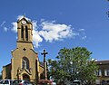
Saint-Vérand church
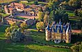
La Flachère Castle
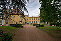
La Garde Castle


Web links
Commons : Saint-Vérand - collection of images, videos and audio files