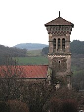
Cenves
| Cenves | ||
|---|---|---|
|
|
||
| region | Auvergne-Rhône-Alpes | |
| Department | Rhône | |
| Arrondissement | Villefranche-sur-Saône | |
| Canton | Belleville | |
| Community association | Saone-Beaujolais | |
| Coordinates | 46 ° 16 ′ N , 4 ° 39 ′ E | |
| height | 335-747 m | |
| surface | 26.48 km 2 | |
| Residents | 391 (January 1, 2017) | |
| Population density | 15 inhabitants / km 2 | |
| Post Code | 69840 | |
| INSEE code | 69035 | |
| Website | http://www.cenves.org/ | |
Cenves is a French municipality with 391 inhabitants (as of January 1 2017) in the department of Rhône in the region of Auvergne Rhône-Alpes . It belongs to the arrondissement of Villefranche-sur-Saône and the canton of Belleville (until 2015: canton of Monsols ). The inhabitants are called Cenvards .
geography
Cenves is the northernmost municipality in the Rhône department. It is located about 14 kilometers west-southwest of Mâcon . The small river Petite Grosne has its source here . Cenves is surrounded by the neighboring communities of Serrières in the north, Vergisson in the northeast, Solutré and Chasselas in the east, Leynes in the east and southeast, Pruzilly in the south and southeast, Juliénas and Jullié in the south, Deux-Grosnes with Saint-Jacques-des-Arrêts in the Southwest, Germolles-sur-Grosne to the west and Tramayes to the west and northwest.
Population development
| 1962 | 1968 | 1975 | 1982 | 1990 | 1999 | 2006 | 2013 | |
|---|---|---|---|---|---|---|---|---|
| 320 | 279 | 283 | 308 | 319 | 328 | 380 | 407 | |
| Source: Cassini and INSEE | ||||||||
Attractions
- Sainte-Foy church from the 19th century
- La Grange-du-Bois priory, founded in 1145

