
Charentay
| Charentay | ||
|---|---|---|
.svg)
|
|
|
| region | Auvergne-Rhône-Alpes | |
| Department | Rhône | |
| Arrondissement | Villefranche-sur-Saône | |
| Canton | Belleville | |
| Community association | Saone-Beaujolais | |
| Coordinates | 46 ° 5 ' N , 4 ° 41' E | |
| height | 175-272 m | |
| surface | 13.78 km 2 | |
| Residents | 1,240 (January 1, 2017) | |
| Population density | 90 inhabitants / km 2 | |
| Post Code | 69220 | |
| INSEE code | 69045 | |
| Website | http://www.mairie-charentay.fr/ | |
 View of Charentay |
||

Charentay is a French commune with 1,240 inhabitants (as of January 1, 2017) in the Rhône department in the Auvergne-Rhône-Alpes region . Charentay belongs to the arrondissement of Villefranche-sur-Saône and the canton of Belleville . The inhabitants are called the Charentois .
geography
Charentay is located about eleven kilometers north-northwest of Villefranche-sur-Saône . It belongs to the Bourgogne wine region . Charentay is surrounded by the neighboring communities of Saint-Lager in the north, Belleville-en-Beaujolais in the north-east, Saint-Georges-de-Reneins in the east and south-east, Saint-Étienne-des-Oullières in the south and south-west and Odenas in the west.
Population development
| year | 1962 | 1968 | 1975 | 1982 | 1990 | 1999 | 2006 | 2013 |
| Residents | 768 | 689 | 705 | 743 | 869 | 993 | 1,053 | 1,197 |
| Source: Cassini and INSEE | ||||||||
Attractions
- Saint Martin Church
- Arginy Castle from the 13th century, current building from the 15th century, Monument historique
- Sermezy Castle from the 18th century, Monument historique
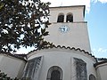
Saint Martin Church
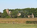
Arginy Castle

Sermezy Castle


Web links
Commons : Charentay - collection of pictures, videos and audio files