
Ternand
| Ternand | ||
|---|---|---|
.svg)
|
|
|
| region | Auvergne-Rhône-Alpes | |
| Department | Rhône | |
| Arrondissement | Villefranche-sur-Saône | |
| Canton | Le Bois-d'Oingt | |
| Community association | Beaujolais Pierres Dorées | |
| Coordinates | 45 ° 57 ' N , 4 ° 32' E | |
| height | 269-741 m | |
| surface | 10.75 km 2 | |
| Residents | 684 (January 1, 2017) | |
| Population density | 64 inhabitants / km 2 | |
| Post Code | 69620 | |
| INSEE code | 69245 | |

Ternand is a French municipality with 684 inhabitants (as of January 1 2017) in the department of Rhône in the region of Auvergne Rhône-Alpes . It belongs to the Arrondissement of Villefranche-sur-Saône , to the canton of Le Bois-d'Oingt and is a member of the Beaujolais Pierres Dorées community .
geography
Ternand is located around 31 kilometers northwest of Lyon and around 15 kilometers west-southwest of Villefranche-sur-Saône in the Bourgogne wine region on the Azergues . Ternand is surrounded by the neighboring communities of Létra in the north, Sainte-Paul in the northeast, Val d'Oingt with Saint-Laurent-d'Oingt in the east and southeast, Saint-Vérand in the south and Dième in the west.
Population development
| year | 1962 | 1968 | 1975 | 1982 | 1990 | 1999 | 2006 | 2012 |
| Residents | 329 | 349 | 411 | 443 | 588 | 625 | 729 | 702 |
| Source: Cassini and INSEE | ||||||||
Attractions
- Notre-Dame-de-la-Nativité church
- Castle ruins from the 12th century
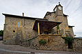
Notre-Dame-de-la-Nativité church

Castle ruins


Web links
Commons : Ternand - collection of images, videos and audio files