
Les Ardillats
| Les Ardillats | ||
|---|---|---|
|
||
| region | Auvergne-Rhône-Alpes | |
| Department | Rhône | |
| Arrondissement | Villefranche-sur-Saône | |
| Canton | Belleville | |
| Community association | Saone-Beaujolais | |
| Coordinates | 46 ° 11 ' N , 4 ° 32' E | |
| height | 334-1,004 m | |
| surface | 23.1 km 2 | |
| Residents | 622 (January 1, 2017) | |
| Population density | 27 inhabitants / km 2 | |
| Post Code | 69430 | |
| INSEE code | 69012 | |
| Website | http://www.lesardillats.fr/ | |
 Town hall of Les Ardillats |
||

Les Ardillats ( frankoprovençalisch : Los Ardilyàts ) is a French municipality with 622 inhabitants (as of January 1 2017) in the department of Rhône in the region of Auvergne Rhône-Alpes . It belongs to the arrondissement of Villefranche-sur-Saône and the canton of Belleville (until 2015: canton of Beaujeu ). The inhabitants are called Villiatons .
geography

Les Ardillats is located about 40 kilometers north-northwest of Lyon in the Bourgogne wine-growing region . The small Ardière river has its source here . Les Ardillats is surrounded by the neighboring communities
- Deux-Grosnes with Monsols in the north, Ouroux in the northeast and Avenas in the east and northeast,
- Beaujeu in the east and south-east,
- Saint-Didier-sur-Beaujeu and Vernay in the south,
- Chénelette in the west and south-west,
- Propières to the west and north-west.
Population development
| 1962 | 1968 | 1975 | 1982 | 1990 | 1999 | 2006 | 2012 | |
|---|---|---|---|---|---|---|---|---|
| 383 | 367 | 369 | 385 | 424 | 483 | 532 | 607 | |
| Source: Cassini and INSEE | ||||||||
Attractions
- Saint-Pierre church
- Castle and domain of Les Ardillats
- Natural monument of a 500 year old chestnut
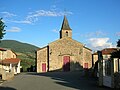
Saint-Pierre church
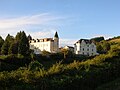
Les Ardillats Castle


Web links
Commons : Les Ardillats - collection of images, videos and audio files