
Theizé
| Theizé | ||
|---|---|---|
.svg)
|
|
|
| region | Auvergne-Rhône-Alpes | |
| Department | Rhône | |
| Arrondissement | Villefranche-sur-Saône | |
| Canton | Le Bois-d'Oingt | |
| Community association | Beaujolais Pierres Dorées | |
| Coordinates | 45 ° 56 ' N , 4 ° 37' E | |
| height | 237-603 m | |
| surface | 11.89 km 2 | |
| Residents | 1,247 (January 1, 2017) | |
| Population density | 105 inhabitants / km 2 | |
| Post Code | 69620 | |
| INSEE code | 69246 | |
| Website | http://www.theize-en-beaujolais.com/ | |
.jpg) Entrance to Theizé |
||

Theizé (also: Theizé-en-Beaujolais ) is a French municipality with 1247 inhabitants (as of January 1 2017) in the department of Rhône in the region of Auvergne Rhône-Alpes . It belongs to the Arrondissement Villefranche-sur-Saône , the canton Le Bois-d'Oingt and is a member of the Beaujolais Pierres Dorées community . The inhabitants are called Theizéens .
geography
Theizé is located around 26 kilometers northwest of Lyon and around nine kilometers southwest of Villefranche-sur-Saône in the Bourgogne wine region . Theizé is surrounded by the neighboring communities
- Ville-sur-Jarnioux in the north and north-west,
- Jarnioux in the north,
- Porte des Pierres Dorées with Pouilly-le-Monial in the north and north-east and Liergues in the north-east,
- Pommiers in the northeast,
- Anse in the east,
- Lachassagne in the southeast,
- Alix in the south and southeast,
- Frontenas in the south,
- Moiré in the south and southwest,
- Val d'Oingt with Oingt in the west.
Population development
| year | 1962 | 1968 | 1975 | 1982 | 1990 | 1999 | 2006 | 2013 |
| Residents | 672 | 643 | 781 | 874 | 915 | 999 | 1,038 | 1.104 |
| Source: Cassini and INSEE | ||||||||
Attractions
- Saint-Antoine church, built between 1898 and 1905
- old church from the 12th / 13th centuries century
- Saint-Hippolyte Chapel, built in 1602
- Rochebonne Castle, rebuilt in the 17th century
- Rapetour Castle
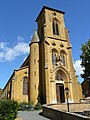
Saint-Antoine church
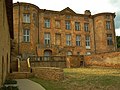
Rochebonne Castle

Rapetour Castle


Personalities
- Charles Lapicque (1898–1988), painter
Web links
Commons : Theizé - collection of images, videos and audio files