Bully (Rhône)
| bully | ||
|---|---|---|

|
|
|
| region | Auvergne-Rhône-Alpes | |
| Department | Rhône | |
| Arrondissement | Villefranche-sur-Saône | |
| Canton | Le Bois-d'Oingt | |
| Community association | Pays de L'Arbresle | |
| Coordinates | 45 ° 51 ′ N , 4 ° 35 ′ E | |
| height | 230-437 m | |
| surface | 12.59 km 2 | |
| Residents | 1,982 (January 1, 2017) | |
| Population density | 157 inhabitants / km 2 | |
| Post Code | 69210 | |
| INSEE code | 69032 | |
| Website | www.bully.fr | |
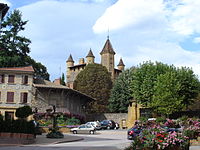
 Bully Town Hall |
||
Bully is a French commune with 1,982 inhabitants (as of January 1 2017) in the department of Rhône in the region of Auvergne Rhône-Alpes . It belongs to the arrondissement of Villefranche-sur-Saône and the canton of Le Bois-d'Oingt (until 2015: canton of L'Arbresle ).
geography
Bully is located about 25 kilometers west-northwest of Lyon in the Beaujolais landscape and belongs to the Bourgogne wine-growing region . Bully is surrounded by the neighboring communities of Le Breuil in the north, Saint-Germain-Nuelles in the east, L'Arbresle in the southeast, Savigny in the south, Saint-Romain-de-Popey in the west and Sarcey in the northwest.
The A89 autoroute and the National Route 7 run through the municipality .
Population development
| year | 1962 | 1968 | 1975 | 1982 | 1990 | 1999 | 2006 | 2012 |
| Residents | 1,039 | 1,032 | 1,095 | 1,224 | 1,464 | 1,739 | 1,973 | 2,082 |
Attractions
- Saint-Polycarpe Church
- Bully Castle from 1480, restored in the 19th century
- town hall
Web links
Commons : Bully - collection of pictures, videos and audio files


