
Saint warehouse
| Saint warehouse | ||
|---|---|---|
|
||
| region | Auvergne-Rhône-Alpes | |
| Department | Rhône | |
| Arrondissement | Villefranche-sur-Saône | |
| Canton | Belleville | |
| Community association | Saone-Beaujolais | |
| Coordinates | 46 ° 7 ′ N , 4 ° 40 ′ E | |
| height | 189-401 m | |
| surface | 7.74 km 2 | |
| Residents | 1,040 (January 1, 2017) | |
| Population density | 134 inhabitants / km 2 | |
| Post Code | 69220 | |
| INSEE code | 69218 | |
| Website | http://www.saintlager.fr/ | |

Saint-Lager is a French commune with 1,040 inhabitants (as of January 1, 2017) in the Rhône department in the Auvergne-Rhône-Alpes region . Saint-Lager belongs to the arrondissement of Villefranche-sur-Saône and the canton of Belleville .
geography
Saint-Lager is located about twelve kilometers north-northwest of Villefranche-sur-Saône . It belongs to the Bourgogne wine region . Saint-Lager is surrounded by the neighboring communities of Cercié in the north, Belleville-en-Beaujolais in the east and northeast, Charentay in the south, Odenas in the southwest and Quincié-en-Beaujolais in the west.
Population development
| year | 1962 | 1968 | 1975 | 1982 | 1990 | 1999 | 2006 | 2013 |
| Residents | 923 | 841 | 839 | 881 | 805 | 874 | 931 | 978 |
| Source: Cassini and INSEE | ||||||||
Attractions
- Notre-Dame chapel
- Saint-Lager Castle, Monument historique

Notre-Dame chapel
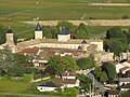
Saint-Lager Castle


Web links
Commons : Saint-Lager - Collection of images, videos and audio files