Mammoth Spring
| Mammoth Spring | |||
|---|---|---|---|
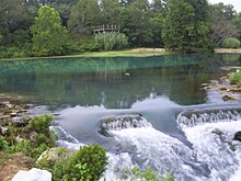
 Mammoth Spring from the east |
|||
| location | |||
| Country or region | Fulton County , Arkansas ( United States ) | ||
| Coordinates | 36 ° 29 ′ 51 ″ N , 91 ° 32 ′ 8 ″ W. | ||
|
|||
| geology | |||
| Mountains | Ozark Mountains | ||
| Source type | Karst spring | ||
| Exit type | Source pot | ||
| Hydrology | |||
| River system | Mississippi River | ||
| Receiving waters | Spring River → Black River → White River → Mississippi River → Gulf of Mexico | ||
| Bulk | 9800 l / s | ||
| depth | 21 m | ||
Coordinates: 36 ° 29 ′ 51 ″ N , 91 ° 32 ′ 8 ″ W.
The Mammoth Spring (German: Mammut -Quelle) is a large karst spring in the state of Arkansas in the United States .
description
The source is located in Fulton County about 100 m south of the Missouri state line , on the outskirts of Mammoth Spring , in Mammoth Spring State Park . It is the largest spring in Arkansas and the third largest in the Ozark Mountains after Big Spring and Greer Spring . Mammoth Spring was founded in 1972 as a National Natural Landmark ( natural monument shown). US Highway 63 runs right past the source .
The circular spring pot of Mammoth Springs has two water drains, one to the east and a smaller one to the south. The spring water then flows into a dammed lake. The Spring River that rises there takes on the Warm Fork Spring River immediately after leaving the lake . The cold spring water creates excellent conditions for trout . Precipitation that falls in southern Missouri seeps into the groundwater and flows through a vast system of tunnels and cavities. An underground watercourse forms in these cavities, which ultimately comes to light in the 21 m deep spring pot of Mammoth Springs.
He pours an average of 9800 liters per second, that a constant temperature of 14 ° C has. Nine miles northwest of Mammoth Spring, part of the underground river can be viewed in a collapsed cave system in Grand Gulf State Park , Missouri. Staining tests have shown a connection to the Mammoth Spring.
See also
Web links
Individual evidence
- ↑ Map from Google Maps
- ↑ USGS Surface Water data for USA: USGS Surface-Water Annual Statistics . Waterdata.usgs.gov. Retrieved November 27, 2012. (English)


