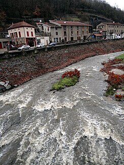
Brévenne
| Brévenne | ||
|
The Brévenne |
||
| Data | ||
| Water code | FR : U4630500 | |
| location | France , Auvergne-Rhône-Alpes region | |
| River system | Rhône | |
| Drain over | Azergues → Saône → Rhône → Mediterranean | |
| source | in the municipality of Maringes 45 ° 39 ′ 42 ″ N , 4 ° 22 ′ 2 ″ E |
|
| Source height | approx. 580 m | |
| muzzle | at Lozanne in the Azergues coordinates: 45 ° 51 ′ 29 " N , 4 ° 40 ′ 24" E 45 ° 51 ′ 29 " N , 4 ° 40 ′ 24" E |
|
| Mouth height | approx. 204 m | |
| Height difference | approx. 376 m | |
| Bottom slope | approx. 9.6 ‰ | |
| length | 39 km | |
| Catchment area | 437 km² | |
| Left tributaries | Turdine | |
| Small towns | L'Arbresle | |
The Brévenne is a river in France that runs in the Auvergne-Rhône-Alpes region . It rises in the municipality of Maringes , drains generally in a north-easterly direction through the historical province of Lyonnais and flows after 39 kilometers at Lozanne as a left tributary into the Azergues . On its way, the Brévenne crosses the Loire and Rhône departments .
Places on the river
Web links
Commons : Brévenne - collection of images, videos and audio files
