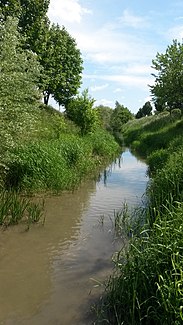
Little Tulln
| Little Tulln | ||
|
The Kleine Tulln in the local area of Tulln |
||
| Data | ||
| location | Lower Austria | |
| River system | Danube | |
| Drain over | Great Tulln → Danube → Black Sea | |
| source | northeast of Rekawinkel 48 ° 11 ′ 32 ″ N , 16 ° 2 ′ 25 ″ E |
|
| Source height | approx. 430 m above sea level A. | |
| Flood overpass | to the Great Tulln in Judenau Coordinates: 48 ° 17 ′ 3 ″ N , 16 ° 0 ′ 45 ″ E 48 ° 17 ′ 3 ″ N , 16 ° 0 ′ 45 ″ E |
|
| Mouth height | 181 m above sea level A. | |
| Height difference | approx. 249 m
|
|
| Catchment area | 71.4 km² | |
| Small towns | ( Tulln on the Danube ) | |
| Communities | Pressbaum , Sieghartskirchen , Asperhofen , Judenau-Baumgarten | |
| old estuary near Tulln on the Danube 48 ° 19 ′ 57 ″ N , 16 ° 6 ′ 45 ″ E | ||
The Kleine Tulln is a river in Lower Austria .
geography
It rises 400 m above sea level. A. as "Koglbach" north of Rekawinkel ( Pressbaum ) flows north via Kogl ( Sieghartskirchen ) (where it is really called Kleine Tulln from the confluence of the Starzbach at the southern end of Kogl) until it (it was like that until the 1980s) years) after a total of about 24 km in Tulln in the district of Tulln in the Danube flowed ( altitude approximately 177 meters above sea level. A. ).
Since the construction of the Danube power station Greifenstein (1981–1985), the flood of the Kleine Tulln in Judenau has flowed into the Große Tulln , the cut off course of the Kleine Tulln from Judenau is connected to the oxbow lakes between Langenlebarn and Greifenstein and flows below the Greifenstein power station into the Danube .
The localities from the Koglbach source to the original mouth are called:
- Sieghartskirchen / Kronstein district
- Asperhofen / Geigelberg district
- Sieghartskirchen / districts of Kogl, Sieghartskirchen, Wagendorf, Henzing
- Judenau-Baumgarten / districts Judenau, Zöfing, Baumgarten, Freundorf
- Tulln on the Danube / districts Staasdorf, Frauenhofen, Tulln city, Langenlebarn
Hydrology
The most important feeders of the Kleine Tulln are from the source (Koglbach) to the mouth (right / left in the orographic sense, i.e. looking downstream):
- Haberbach (right)
- Schönbach (left)
- Starzbach (left)
- Röhrenbach (left)
- Rossbach (Bonnabach / Rappoltenkirchner Bach) (right)
- Elsbach (right)
The catchment area originally comprised 96.6 km² ( 71.4 km² to Judenau ).
geology
From the source to Asperhofen / Geigelberg, the Kleine Tulln (still called “Koglbach” here) flows through the flysch zone ( sandstone , marl and claystone from the Cretaceous to the Palaeogene / Old Tertiary). Most of the rocks are impermeable to water, so that rainwater or meltwater gets into the river after a short time.
In Sieghartskirchen / district of Kogl the Kleine Tulln (Koglbach) crosses the narrow zone of the subalpine molasse . These are folded conglomerates (Buchberg, Hohe Warte) and fine-grained sediments , which, however, due to the narrow width of this zone, have no effect on the runoff in the Kleine Tulln.
From Sieghartskirchen the Kleine Tulln flows through the Molasse . These are mainly sands , silts and clays ( Schlier ) from the Neogene , which are sometimes overlaid by loess . These loose rocks are also slightly water-permeable, but due to their poor stability , the terrain is mostly so flat that large amounts of water no longer arise from this area.
The Kleine Tulln runs or ran down the river from Judenau to its (former) confluence in the Tullnerfeld , a broad Quaternary gravel area in which no surface runoff occurs, as the terrain is practically horizontal and precipitation can seep into the well-drained gravel and sand .
Names
Since 1810 at the latest, the body of water has been called the Little Tulln . Before that and until around 1905 it was also known as the small Tulnerbach or the small Tullnerbach , although there is a risk of confusion with the south-flowing Tullnerbach , which enters the Danube via the Vienna River .
Web links
- Dismantling "Kleine Tulln"
- Greifenstein power plant
- Wienerwald Online with history, natural history and geology
Individual evidence
- ↑ a b BMLFUW (ed.): List of areas of the river areas: Danube area from the Enns to the Leitha In: Contributions to Austria's Hydrography Issue 62, Vienna 2014, p. 102. PDF download , accessed on July 8, 2018.
