
Vienna (river)
| Vienna | ||
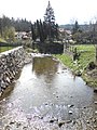
 The Vienna in the area of the Wiener Stadtpark |
||
| Data | ||
| location | Lower Austria and Vienna , Austria | |
| River system | Danube | |
| Drain over | Danube → Black Sea | |
| source | at Kaiserbrunnberg at Rekawinkel 48 ° 9 '38 " N , 16 ° 2' 17" E |
|
| Source height | 540 m above sea level A. | |
| muzzle | in Vienna-Weißgerber in the Danube Canal 48 ° 12 '43 " N , 16 ° 23' 4" E |
|
| Mouth height | 155 m above sea level A. | |
| Height difference | 385 m | |
| Bottom slope | 11 ‰ | |
| length | 34 km | |
| Catchment area | 221.2 km² | |
| Left tributaries | Weidlingbach , Gablitzbach , Mauerbach | |
| Right tributaries | Rotwassergraben , Grünauer Bach , Hirschenbach , Lainzerbach | |
| Reservoirs flowed through | Wienerwaldsee | |
| Big cities | Vienna | |
| Small towns | Purkersdorf | |
| Communities | Pressbaum , Tullnerbach | |


The Wien or Wienfluss is a river that has its source in the western Vienna Woods at Rekawinkel and flows into the Danube Canal in the 1st and 3rd districts of Vienna at the Urania . It has a length of 34 kilometers and a catchment area of 221 square kilometers . Although the river also flows through urban areas, it has an alpine character and is considered white water .
geography
geology
The 221-square-kilometer catchment area of the river Wien is located in the Sandstone area of the Vienna Woods . The sandstone soil cannot absorb precipitation and meltwater, or only insufficiently. Furthermore, the gradient of the Wien River is quite high at the beginning. As a result, the amount of water in the Vienna River can swell rapidly within a short period of time during heavy rainfall. On July 6, 2009, the level of the Vienna River at the Kennedybrücke measurement site rose by over one meter within 10 minutes. During floods, the Wien River carries up to 450,000 liters of water per second, but normally only 200, a ratio of over 2000: 1.
course
About half of Vienna runs in the federal state of Lower Austria and the other half in Vienna.
It has two source rivers: the Dürre Wien and the Kalte Wien . The drought in Vienna rises 520 meters above sea level on Kaiserbrunnberg near Rekawinkel , where there is also a well-shaped socket. The Kalte Wien (also Great Vienna) rises below the Hengstlberg in the Wolfsgraben community . When the droughts and the Cold Vienna in the center of Pressbaum ( ⊙ ) merged, the river was simply called Vienna .
The tributaries of the Dürren Wien are Sanatoriumsgraben with Pelzergraben, Haitzawinkelgraben, the most important tributary of the Cold Vienna is the Pfalzauer Bach .
At the confluence with the Wolfsgrabenbach, the Wien River is dammed in the Wienerwaldsee for the Wiental waterworks . This lake was originally built to supply Vienna and Purkersdorf with drinking water and was used for this for a long time. Today it is used as a retention basin . After Pressbaum, the Wien River flows briefly through the local area of Tullnerbach and further through the urban area of Purkersdorf. Tributaries to Vienna are: the Saubach, the Weidlingbach, the Brentenmaisbach (Pressbaum), the Norbertinumsbach (Tullnerbach), the Wolfsgrabenbach, the Tullnerbach , the Dambach, the large Steinbach, the Kleine Steinbach, the Deutschwaldbach, the Gablitzbach (Purkersdorf).
The city of Vienna reaches the Wien am Mühlberg (14th district, Penzing ). Tributaries in Vienna are: the Mauerbach , the Halterbach, the Wurzbach, the Hirschenbach , the Rotwassergraben and the Grünauer Bach . The Marienbach , the Lainzerbach , the Rosenbach and the Ameisbach can no longer be seen today as far as the mouth, but soon flow into the municipal sewer system.
From the Auhof substation onwards , Vienna forms the border between the orographic left bank districts 14, 15, 6 and 1 ( Penzing , Rudolfsheim-Fünfhaus , Mariahilf and Innere Stadt ) and the right bank districts 13, 12, 5, 4 and 3 ( Hietzing , Meidling , Margareten , Wieden and Landstrasse ).
In the course of Vienna, the Wien River was laid in an artificial concrete bed in order to prevent the devastating floods that were common up until the end of the 19th century (the name of the suburb of Gumpendorf in today's 6th district of Vienna is a reminder of this ). Sometimes it is completely vaulted in Vienna. In the area of the Vienna City Park , its course was used as a landscape design element.
In the 13th district of Vienna, Hietzing , there was a Mühlbach, which was diverted from Vienna to the left (north) in Hütteldorf , then to the right (south) at Preindlsteg on a trough bridge over the Vienna and in the Neue area Welt (near the junction of Lainzer Strasse from Hietzinger Hauptstrasse) flowed into the (now piped) Lainzerbach. To it reminds the Feldmühlgasse , wherein the eponymous field mill was in the Auhofstraße (height no. 78).
history
From around the year 1100 many small mills settled on the banks of the Wien River. The Counts of Forrnbach acted as porters and organizers. Vineyards and inns were often attached to the mills. Wood processing companies settled around the mills, as the wood in the mills often had to be replaced.
Two artificial arms of the Wien River have been handed down as mill streams near the city. One branched off at the Meidlinger Wehr and fed the Dorotheermühle in today's Hofmühlgasse 7, the Kirchen- or Angermühle in Mollardgasse, the Mollardmühle and the Dominikanermühle (all in the 6th district). It flowed into the Vienna River at the Gumpendorfer Weir. The second mill stream began at the Gumpendorfer weir, flowed through parts of today's 4th district, Wieden , and ran the grinding, hay and bear mills .
Regulatory measures were announced as early as 1713 and 1781 (project by Schönbrunn garden architect Johann Wilhelm Beyer 1785), but convicts only dug a deeper river bed and planted willows and acacias on the banks .
In 1860 Josef Maximilian Petzval developed a concept for the partial vaulting and a double-track railway on the bank. These plans were initially not accepted. After the catastrophic flooding of 1862, the state , Crown Land of Lower Austria and the City of Vienna largely adopted this concept, which, in addition to regulating the Danube and the Danube Canal, also aimed at regulating the Vienna River. The Vienna river regulation was not implemented until the 1890s, long after the Danube regulation was completed in 1875.
environment
Buildings and regulatory measures
Two young engineers, Atzinger and Grave, wanted to make the Wien River navigable. They published their project in 1874 with Alfred Hölder , Beck'sche Universitätsbuchhandlung Vienna. With the help of six water reservoirs they wanted to give the river enough water: Wien-Schiffahrts-Canal, depth 1.9 m, width 28.4 m ... screw steamers were supposed to be on the move here and not to transport people, but mainly building materials. The project was not processed further.
A commission of experts described the situation in 1882 as follows:
“It is perfectly justified if there is complaint on all sides that the Vienna river from Purkersdorf to its entry into the soft area of Vienna is a drainage ditch for waste water of all kinds, and that the water of the Vienna river in its lower part is no longer river water, but a liquid manure rigid with animal and vegetable waste. [...] It is mainly the fermentation and dyeing works, the chemical factories and the Hütteldorfer brewery which have the greatest share in the water spoilage and the pollution of the banks. "
The still effective Wienfluss regulation on a flow distance of 17 km was the Imperial Council , the Cisleithanian Parliament, 1892 in the Law on the Execution of public transport facilities in Vienna decided and under the responsibility of the kk below Trade Minister Commission for traffic installations in Vienna realized.
The state , the state of Lower Austria and the municipality of Vienna each contributed 5 million guilders to the cost of regulation, estimated at 15 million guilders (inflation-adjusted 2016: 200 million €) . The detailed program of the projects attached to the law, to which the Vienna light rail system belonged, required a flow rate of up to 600 m³ per second for the new Vienna river bed. In 1894, the commission transferred the work to the Vienna City Building Authority.
In the Vienna Woods , a reservoir, the Wienerwaldsee , was built near Pressbaum to regulate floods . In the west of Vienna near Auhof , attempts have been made and are being tried to regulate the runoff of the Vienna through flood retention basins - the Auhof retention basins . In the course of the renaturation of the Wien River, some of the reservoirs are already forming a large wet biotope .
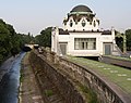
In the urban area of Vienna, the river runs almost entirely in a deep concrete bed. It was built between 1895 and 1899 to channel the river's devastating floods . This happened at the same time as the Vienna Stadtbahn's Wientallinie, which crosses the river from the Zufferbrücke between Hütteldorf and Hacking (since 1938: 13th / 14th district) to Johannesgasse near the Stadtpark (1st / 3rd district) on its right, on the south side in a lower position, separated from the river bed by a wall.
Otto Wagner , architectural designer of the Stadtbahn, had campaigned for the river to be vaulted in the course of the construction of the Stadtbahn from Schönbrunn (13th district) to Karlsplatz (1st / 4th district) and on the vaulting a boulevard ( Wienzeile ) between the imperial residence To build Schönbrunn Palace and the city center; However, the vault was only built on a smaller section of 2.8 km, starting downstream of the Pilgram Bridge (see Vienna River Bridges ).
For urban sewage , collecting canals were built on both sides of the canalised river , the cholera canals , which had overflows into the river bed, which became active during heavy rain or maintenance work. To remedy this, the Wiental Canal was built in 1997–2001 and 2003–2006 , a 3,500 meter long tube under the Vienna River, which is located at Ernst-Arnold-Park (5th district) on Pilgramgasse from the right Vienna River collecting canal branches off and flows into the Urania right main collecting canal relief canal, which was completed in 2000. It also serves as a storage tank and can hold up to 110,000 cubic meters of wastewater. The most difficult section was crossing the U1 line in the area of Karlsplatz, where the canal runs just 3 meters below the subway shaft.
As a result, there were repeated plans to vault the walled bed of the Vienna or to build a Wiental motorway or expressway in it. The use of the Wien river bed as an urban motorway was discussed primarily in the 1960s. Mayor Felix Slavik ended this speculation on September 2, 1972 with a keynote address at the Forum Alpbach .
Wienflussweg
Plans in the late 20th century to make the concrete bed accessible to pedestrians and cyclists were due to the rapid changes in level only about seven kilometers between Auhof and Kennedybrücke , on the left, northern edge of the river bed (14th district) with appropriate warning systems and ramps to street level implemented.
For a short time incorrectly advertised as the Wienfluss Highway in political public relations , as was determined on the occasion of conflicts of use, it is not a high-speed route for cyclists, but a leisure route for pedestrians, cyclists and children playing. On the remaining (following) stretch of the river in Vienna, a bike path at street level accompanies the river in parts.
future
Since the Wiental is mainly used for transport, its recreational factor is only small within Vienna. In the Vienna urban development plan of 2005, efforts were therefore made not to narrow the valley any further or to build over it, and to set up recreational opportunities in already built-up areas. First and foremost, the redesign in the Schönbrunn area should be mentioned here.
In October 2013, renaturation began between the Bräuhausbrücke / Halterbach estuary and Nikolaisteg. In addition to flood safety, the focus was on the recreational value of the water. In addition, it should become the home of plants and animals typical of the water. The construction work was completed on schedule in March 2014.
Attractions
In the immediate vicinity of the river is located at the junction of Hietzing after Meidling the Schoenbrunn Palace . On the further course of Vienna, in the 6th district, are the Naschmarkt and the Theater an der Wien . After the river was regulated, Otto Wagner had the aforementioned vision of turning the Wienzeile into an Art Nouveau splendid street; his Vienna row houses in the 6th district bear witness to this .
There are also some of Wagner's station buildings along the Wiental, which were built for the Vienna Steam City Railway and later used by the Vienna Electric City Railway, which ran there until 1981 . The kilometer-long Otto Wagner railing , which can also be found in large numbers along the Vienna River , was created as an accessory to the Stadtbahn . There are also buildings by Jože Plečnik (5th, Langer rental house) and Oskar Marmorek (5th, Rüdigerhof ) from the same period . The Wiener Stadtpark (1st and 3rd district), through which the Vienna flows in its penultimate section, is one of the most important green spaces in the city. Shortly before the mouth of the river, the Viennese Citizens' Theater (3rd district), the MAK (Museum of Applied Arts, 1st district), the University of Applied Arts (1st), the historic main customs office ( 3rd district) are or were on its banks .), the Austro-Hungarian War Ministry (1st) and Urania (1st district).
photos
The place in Pressbaum, where the cold and the drought form the Vienna river
Wagner's Stadtbahn Hofpavillon (13th district) at the Hietzing underground station
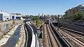
The Vienna at Längenfeldgasse in the 12th district, in the middle of the picture the U6, on the far right the route of the U4
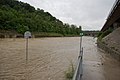
The flood-bearing Wien River in June 2009

Theater an der Wien , around 1815, the Wien River at the bottom of the picture

Regulation and vaulting in the Karlsplatz area (1897–1898)

Regulation and vaulting in the Karlsplatz area (1897–1898)

Wiener Bürgerertheater in the 3rd district (1905–1960), Vordere Zollamtsstraße 13 , also a theater "an der Wien"


See also
literature
- chronological -
- Otto Schneider: The Wiental in Meidling. In: sheets of the Meidlinger district museum. Vienna 1968, issue 2.
- Klaus Lohrmann: The old mills on the Vienna. Vienna 1980.
- Karlheinz Roschitz (text), Peter Dressler, Franz Zadrazil : Das Wiental. Vienna / Munich 1983, ISBN 3-224-16027-6 .
- Ernst Gerhard Eder: The Vienna River and Power in the State. Marginalia on nature, settlement and transport development, economy and politics. In: Austria in history and literature , vol. 41, 1997, no. 4b-5, pp. 354–368.
- Ludwig Varga: Crossings in Meidling - Part 2. Crossings in the area of the Vienna River. In: Sheets of the Meidlinger District Museum , Vienna 2006, issue 66.
- Sándor Békési: The Metamorphoses of the Vienna River. On the history of the socialization of nature using the example of an urban body of water. In: Yearbook of the Association for the History of the City of Vienna , (= Studies on Viennese History , 66), Vienna 2010, ISSN 1027-8788 , pp. 37–61.
- Josef Holzapfel: The Vienna - From the Kaiserbrünndl to the Danube. Sutton, Erfurt 2014, ISBN 978-3-95400-400-3 .
Movies
- The Vienna River - Vienna Waters. Documentary, Austria, 2018, 45:13 min., Script and director: Norman, Roswitha and Ronald P. Vaughan, production: Vaughan Video, ORF , series: Erbe Österreich , first broadcast: March 6, 2018 on ORF III , summary by ORF .
- unknown: Vienna. Documentary, Austria, 2015, 2:30 min., Design: Bohmann, production: City of Vienna, Internet publication: July 24, 2015, online video.
Web links
- The new Vienna River. ( Memento from June 26, 2009 in the Internet Archive ). In: Dept. Hydraulic Engineering of the City of Vienna
- The Vienna River in Penzing with views of 25 Vienna River bridges and the search for traces of the Ameisbach tributary . In: buergmann.info
- Vienna (river) as an interactive 360 ° × 180 ° panorama photo (requires Adobe Flash )
History of the Vienna River
- The Wiental - urban development project. In: City of Vienna
- Vienna River in the Vienna History Wiki of the City of Vienna
- The vault of the Wien River. ( Memento from January 11, 2008 in the Internet Archive ) In: wienschau.at
Individual evidence
- ↑ BMLFUW (Hrsg.): Area directory of the river areas: Danube area from the Enns to the Leitha. In: Contributions to Austria's Hydrography Issue 62, Vienna 2014, p. 112. PDF download , accessed on July 8, 2018.
- ^ Wienfluss, runoff regime in the Vienna History Wiki of the City of Vienna
- ↑ Thomas Ofenböck: The implementation of the National Water Management Plan in Vienna. ( Memento from July 21, 2015 in the Internet Archive ). In: Magistrat Wien, MA 45 - Wiener Gewässer , February 28, 2013, presentation slides, (PDF; 9.7 MB), slide / page 14.
- ^ Vienna river flood protection. In: City of Vienna , Wiener Gewässer (Magistratsabteilung 45) , accessed on March 18, 2018.
- ^ Wien.gv.at: Course and catchment area of the Wien River
- ↑ Hans K.Kaiser: Josef Petzval - the 110th anniversary of the death. In: Internationale Mathematische Nachrichten , December 2001, pp. 9–19, on the Vienna River: pp. 12f., Accessed on March 17, 2018.
- ↑ Franz Atzinger, Heinrich Grave: History and conditions of the Vienna river as well as applications for its utilization with consideration of the current general and local requirements . Beck'sche Universitäts-Buchhandlung, Vienna 1874 ( archive.org [accessed on February 20, 2016] "At the instigation of the concessionaire Franz Zaillner von Zaillenthall", online from Google books ).
- ↑ Beppo Beyerl: The Naschmarkt - ship ahoy at the Stubenbrücke. In: wienernaschmarkt.eu , o. J.
- ^ Report of the experts appointed by the City Council of the City of Vienna on the regulation of the Vienna River in August 1882 . Municipal Council Presidium, Vienna 1882, 5. The sanitary conditions of the Vienna River , p. 41 ( n47 - Internet Archive [accessed February 21, 2016]).
- ↑ RGBl. No. 109/1892 (= p. 621 ff.)
- ↑ LGBl. No. 42/1892 (= p. 85)
- ↑ Erich Dimitz: The mills, the bridges, the drinking water and the regulation of the Vienna River in Mariahilf. In: District Museum Mariahilf , with detailed information and many illustrations, (PDF file; 42 p., 3.8 MB).
- ↑ Karl Wögerer: Sima: Wiental Canal is a milestone for water protection. In: City of Vienna , August 29, 2006, with details of the technical data.
- ↑ Thomas Rottenberg: Wiental Cycle Path: A cycle path that isn't really any. In: Der Standard , Vienna, July 19, 2013 and print edition from May 20/21 July 2013, p. 9.
- ↑ Vienna River, close to nature: part finished. In: Vienna. orf.at . March 22, 2014, accessed March 17, 2018 .
Coordinates: 48 ° 11 ′ 12 ″ N , 16 ° 19 ′ 2 ″ E