Lainzerbach
|
Lainzerbach Lainzer Bach |
||
|
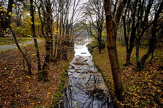
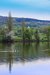
Lainzerbach shortly before the Lainzer pond |
||
| Data | ||
| location | Vienna , Austria | |
| River system | Danube | |
| Drain over | Right Vienna river collecting canal → Vienna river → Danube → Black Sea | |
| source | in the Lainzer Tiergarten 48 ° 9 ′ 44 ″ N , 16 ° 13 ′ 52 ″ E |
|
| muzzle | in Hietzing underground in the right Vienna river collecting canal coordinates: 48 ° 11 ′ 19 ″ N , 16 ° 17 ′ 58 ″ E 48 ° 11 ′ 19 ″ N , 16 ° 17 ′ 58 ″ E
|
|
| length | 7.6 km | |
| Catchment area | 3 km² | |
| Left tributaries | Vösendorfer Graben , Katzengraben , Lackenbach | |
The Lainzerbach , also Lainzer Bach , is a brook in the 13th district of Hietzing in Vienna . It is a feeder of the right Vienna river collecting canal and is partly managed as a brook canal .
course
The Lainzerbach has a length of 3830 m with a height difference of 110 m in its initially above-ground course. Its catchment area is 3 km².
The stream has its source in the Lainzer Tiergarten nature reserve in the Vienna Woods . There it flows through the 1.5 hectare Hohenauer pond, into which the Vösendorfer Graben flows on the left . In its near-natural upper course, the Lainzerbach runs through a narrow Kerbtal , which then widens. The upper course through the Inzersdorfer Wald to the Hohenauer Teich is also known as the Inzersdorfer Graben .
In the Lainzer Tiergarten, the Katzengraben follows as a left tributary , which is occasionally mentioned as an alternative upper course of the Lainzerbach. Outside the zoo wall, the stream initially continues above ground, parallel to Lainzerbachstrasse. It flows through the Lainzer pond in the Lainzerbachwiese so named in 1990. In geological terms, the stream is in flysch . He goes through Santon - Campan layers and red Cenomanian - slate .

The Lainzerbach runs through the Speising , Lainz and Hietzing districts as a 3,818 m long canal. The sink at his intake structure on Ebersberggasse holds 600 m³. The Bachkanal follows Speisinger Straße and the arc of Lainzer Straße around the Küniglberg . It takes the Lackenbach underground . The 4 to 8 m deep Lainzerbach Canal has a gradient of 6, 8 and 15 ‰. At the intersection of Dommayergasse and Hietzinger Kai, the Lainzerbach flows underground into the right Vienna river collecting canal.
The water flow of the Lainzerbach fluctuates greatly. The mean discharge (MQ) in the above-ground section is less than 0.01 m³ / s, while 17.0 m³ / s are reached during a flood of the century . There is little risk of flooding. In the event of a flood of the century, infrastructure is affected to a lesser extent, but no resident population.
history
The Lainzerbach was completely open before the canal was built. In Lainz and Speising it was already influenced by people in the middle of the 18th century, for example through the drainage ditches that were introduced. It did not flow directly into the Wien River, but into the Mariabrunn Mühlbach, which was later filled in . The Hohenau pond was artificially created between 1780 and 1825. At Speising, the Lainzerbach was diverted to an irrigation canal further away from the settlement and the Rosenberg ditch coming from the Rosenhügel was introduced .
Accompanied by strong settlement growth, in addition to further regulations, the first underground sections were built in the localities of Lainz and Hietzing by 1875. The lower, 2194 m long section of the Bach Canal was built in 1895 and 1900. The upper, 1624 m long section was vaulted from 1904 to 1910. After the First World War , the Lainzerbach was hard-built in the area of the settlements in the Lainzer Tiergarten . The Lainzer pond now had permanent water.
The overground stream between Lainzer Teich and Glawatschweg was renatured from 1994 to 1998 by means of demolition . In 2012, further dismantling and reconstruction followed up to the inlet structure of the brook canal. The Lainzer pond was dredged in 2017 as part of renovation work.
ecology
In its upper reaches, the Lainzerbach flows through a dense forest area. Stripes of near-natural black alder , ash and alluvial forests grow downstream of the Hohenauer pond . In the lower section of its above-ground course, the stream only has a moderate water quality . The Hohenau pond and the Lainzer pond are eutrophic bodies of water. In the area outside the Lainzer Tiergarten, some caddis flies species that were on Austria's Red List of Endangered Species were observed : Synagapetus moselyi , Lithax obscurus , Tinodes pallidulus , Athripsodes bilineatus , Athripsodes albifrons and Micropterna lateralis .
bridges
The Lainzerbach is crossed by the following bridges, lined up in the direction of flow:
- Treumann Bridge: The 7 m long and 9 m wide reinforced concrete road bridge on Treumanngasse was built in 1952.
- Waldemarsteg: The 9 m long and 3 m wide reinforced concrete footbridge on the Waldemarweg was built in 1959.
- Glawatschsteg: The 9 m long and 3 m wide reinforced concrete pedestrian bridge on the Glawatschweg was built in 1959.
- Kalman Bridge: The 10 m long and 8 m wide reinforced concrete road bridge on Kalmanstrasse was built in 1953.
- Schoberbrücke: The 11 m long and 12 m wide concrete road bridge on Dr.-Schober-Strasse was built in 1942.
See also
literature
- Rosemarie Forster, Otto Moog: The soil fauna as an indicator of ecological functionality. Case study - the renaturation of Lainzerbach . In: Ecology and Protective Hydraulic Engineering in the City? Symposium on 22./23. May 1996 . Symposium volume. MA 45 - Hydraulic Engineering, Vienna City Administration, Vienna 1996, p. 135-141 .
- Julia Tanzer: Historical morphological changes in the southern Viennese Danube feeder 1755–2010 . Master thesis. University of Natural Resources and Life Sciences, Vienna 2016, Chapter 5.3.1 Lainzerbach , p. 67-75 ( boku.ac.at [PDF]).
Web links
- The Lainzerbach. In: 1133.at. April 2013.
- Lainzerbach. In: Hietzing.at.
Individual evidence
- ↑ a b c brooks by district. Economy, Labor and Statistics (Municipal Department 23), Municipal Authority of the City of Vienna, accessed on January 3, 2020 .
- ↑ a b c d Hans Stadler: The drainage systems of the city of Vienna . Municipal Department 30, Municipal Authority of the City of Vienna, Vienna 1960, p. 38 ( digital.wienbibliothek.at [PDF; accessed on January 3, 2020]).
- ^ A b c Julia Tanzer: Historical morphological change in the southern Viennese Danube feeder 1755-2010 . Master thesis. University of Natural Resources and Life Sciences, Vienna 2016, p. 67 and 69 ( boku.ac.at [PDF; accessed January 3, 2020]).
- ↑ a b c d Johanna Scheiblhofer, Wolfgang Schranz: Diverse nature in Hietzing. (PDF) Biosphärenpark Wienerwald Management GmbH, December 2019, pp. 109–110 , accessed on January 3, 2020 .
- ^ A b Adrian E. Scheidegger : Morphotectonics on the western edge of the Vienna basin . In: VGI - Austrian Journal for Surveying and Geoinformation . tape 86 , no. 2 , 1998, p. 94–95 ( ovg.at [PDF; accessed January 3, 2020]).
- ↑ Felix Czeike (Ed.): Lainzerbachwiese. In: Historisches Lexikon Wien . Volume 3, Kremayr & Scheriau, Vienna 1994, ISBN 3-218-00545-0 , p. 662 ( digitized version ).
- ↑ MA 45, review of the discharge capacity of various torrents in connection with flood protection. Activity report 2014. (PDF) City Audit Office Vienna, April 2014, p. 8 , accessed on January 3, 2020 .
- ^ A b c Julia Tanzer: Historical morphological change in the southern Viennese Danube feeder 1755-2010 . Master thesis. University of Natural Resources and Life Sciences, Vienna 2016, p. 71 ( boku.ac.at [PDF; accessed January 3, 2020]).
- ↑ Anja Gaugl: Lainzerbach: Back to nature. In: mein district.at. June 29, 2015, accessed January 3, 2020 .
- ↑ Johanna Scheiblhofer, Wolfgang Schranz: Diverse nature in Hietzing. (PDF) Biosphärenpark Wienerwald Management GmbH, December 2019, p. 94 , accessed on January 3, 2020 .
- ↑ Rosemarie Forster, Otto Moog: The soil fauna as an indicator of ecological functionality. Case study - the renaturation of Lainzerbach . In: Ecology and Protective Hydraulic Engineering in the City? Symposium on 22./23. May 1996 . Symposium volume. MA 45 - Hydraulic Engineering, Vienna City Administration, Vienna 1996, p. 137-138 .
- ↑ Bridge Information Vienna. Vienna Bridge Construction and Foundation Engineering (Municipal Department 29), Municipal Authority of the City of Vienna, accessed on January 3, 2020 .


