
Kaiserbrunnberg
| Kaiserbrunnberg | ||
|---|---|---|
| height | 576 m above sea level A. | |
| location | Lower Austria , Austria | |
| Mountains | Vienna Woods | |
| Dominance | 0.55 km → Jochgrabenberg | |
| Notch height | 28 m ↓ L126 | |
| Coordinates | 48 ° 9 '34 " N , 16 ° 2' 0" E | |
|
||
| Normal way | Footpath | |

The Kaiserbrunnberg is 576 m above sea level. A. high mountain in the Lower Austrian Vienna Woods .
The wooded mountain is located west of the federal capital Vienna, immediately south of the western motorway . The closest village is the hamlet of Pfalzberg to the east . Larger places are Eichgraben in the northwest, Rekawinkel in the north and Pressbaum in the northeast. Neighboring mountains are the Jochgrabenberg ( 645 m ) in the west and the Große Pfalzberg ( 504 m ) in the east.
The summit of the Kaiserbrunnberg can be reached via a footpath that leads over the mountain in a west-east direction.
The water collects north of the Kaiserbrunnberg and forms first the drought Vienna and then the Vienna river at an altitude of 520 m . The source of the Wien river, which was recast in 1957 , is said to have visited Empress Elisabeth on her walks on April 23, 1884 (memorial plaque on the so-called "Kaiserbrünndl").

Area of Pressbaum around 1790 under the name "Tonnering" (center left), south of it is said to be the then assumed source of the Vienna.

Recording sheet 4756-2c Cut-out of pressed tree

Kaiserbrünndl - the source of the Wien river on Kaiserbrunnberg / Pfalzberg near Pressbaum
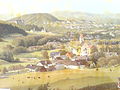
Pressbaum around 1880, lithograph after a painting by G. Varrone (private collection). The mountains around Pressbaum can also be seen in the background.


See also
- Kaiserbrunn on the Rax
Web links
Individual evidence
- ↑ a b c Federal Office for Metrology and Surveying : Austrian Map 1: 50,000, AMAP Online , accessed on June 18, 2011
- ^ Felix Czeike : Historisches Lexikon Wien , Vol. 3, p. 420