Pettnau
|
Pettnau
|
||
|---|---|---|
| coat of arms | Austria map | |
|
|
||
| Basic data | ||
| Country: | Austria | |
| State : | Tyrol | |
| Political District : | Innsbruck country | |
| License plate : | IL | |
| Surface: | 10.76 km² | |
| Coordinates : | 47 ° 18 ' N , 11 ° 10' E | |
| Height : | 628 m above sea level A. | |
| Residents : | 1,065 (January 1, 2020) | |
| Postal code : | 6408 | |
| Area code : | 05238 | |
| Community code : | 7 03 39 | |
| NUTS region | AT332 | |
| UN / LOCODE | AT 7TA | |
| Address of the municipal administration: |
Tiroler Strasse 114 6408 Pettnau |
|
| Website: | ||
| politics | ||
| Mayor : | Martin Schwaninger (General List Pettnau) | |
|
Municipal Council : (2016) (11 members) |
||
| Location of Pettnau in the Innsbruck-Land district | ||
 Pettnau from the Hattinger-Berg |
||
| Source: Municipal data from Statistics Austria | ||
Pettnau is a municipality with 1065 inhabitants (as of January 1, 2020) in the Innsbruck-Land district in Tyrol ( Austria ). The community is located in the judicial district of Telfs .
geography
Pettnau (not to be confused with Pettneu am Arlberg ) is located in the Inn Valley west of Innsbruck .
Districts
The elongated community north of the Inn consists of the districts, from east to west
- Dirschenbach
- Leiblfing
- Tiefental
- Unterpettnau
- Mitterpettnau
- Cellar valley
- Oberpettnau
Neighboring communities
Flaurling , Hatting , Inzing , Polling in Tirol , Reith bei Seefeld , Telfs , Zirl
Place name
The place name is probably made up of the Middle High German word "bette" or "pette", which means something like trough or pond, and the word "Au". Consequently, the place name refers to the Innauen, which however disappeared when the artificial stream bed was created. Outdated variants of the place name such as "Pettnave" or "Pettenawe" appear in the chronicle.
The name of the district Leiblfing goes back to the immigration of the Bavarians. The resident clan probably called themselves "Leuwolf" or "Libolv", the ending -ing is typical for Bavarian settlements.
Population development

politics
The last municipal council and mayoral elections took place on February 28, 2016.
mayor
In the mayoral election in 2016, Martin Schwaninger was elected mayor.
| Mayoral candidate | percent | be right |
|---|---|---|
| Martin Schwaninger | 76% | 399 |
| Ferdinand Hermann Pentscheff | 24% | 126 |
Municipal council
The municipal council consists of 11 members and has been composed as follows since the municipal council election in 2016:
| Voter group | percent | be right | Seats on the local council |
|---|---|---|---|
| General list Pettnau - ALP | 44.44% | 236 | 5 |
| Moving Pettnau together | 15.25% | 81 | 1 |
| List Pettnau Franz Haider | 40.30% | 214 | 5 |
Franz Haider was elected Vice Mayor after the municipal council election in 2016.
coat of arms
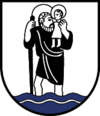
The community coat of arms, awarded in 1973, shows St. Christopher carrying the baby Jesus across the water on his shoulders. The patron of the ferrymen reminds us that three ferries once crossed the Inn in the municipality of Pettnau.
Culture and sights
- The Mellaunerhof with its baroque Lüftlmalerei has been handed down since 1291 and is therefore one of the oldest inns in Tyrol. It used to be used as a salt transshipment point and post office, as there was regular ferry traffic across the Inn between Pettnau, Flaurling and Hatting.
- The parish church of Leiblfing, consecrated to St. George , is a landmark of the region. It has both a pointed and an onion dome, which is unique in the world. A renovation was already documented in 1090, the last renovation took place in summer 2013. Leiblfing has developed into an attractive residential area.
Personalities
- Friedrich Haider (1921–2009), folklorist, folklore researcher and radio worker
traffic
At the Inntalautobahn the roadhouse Pettnau, which can be approached from both directions is located. Although Pettnau does not have its own motorway exit, it is possible to drive up and down the Inntal motorway from the Pettnau motorway service station.
Web links
- 70339 - Pettnau. Community data, Statistics Austria .
- Pettnau , in the history database ofthe association "fontes historiae - sources of history"


