
Wattenberg
|
Wattenberg
|
||
|---|---|---|
| coat of arms | Austria map | |
 |
|
|
| Basic data | ||
| Country: | Austria | |
| State : | Tyrol | |
| Political District : | Innsbruck country | |
| License plate : | IL | |
| Surface: | 67.86 km² | |
| Coordinates : | 47 ° 16 ' N , 11 ° 36' E | |
| Height : | 1050 m above sea level A. | |
| Residents : | 742 (January 1, 2020) | |
| Postal code : | 6113 | |
| Area code : | 05224 | |
| Community code : | 7 03 66 | |
| NUTS region | AT332 | |
| Address of the municipal administration: |
Wattenberg 23a 6113 Wattenberg |
|
| Website: | ||
| politics | ||
| Mayor : | Franz Schmadl (Wattenberg citizens' list) | |
|
Municipal Council : (2010) (11 members) |
||
| Location of Wattenberg in the Innsbruck-Land district | ||
  |
||
 Wattenberg |
||
| Source: Municipal data from Statistics Austria | ||

Wattenberg is a municipality in the Tyrolean Unterland about 20 km east of Innsbruck in the Lower Inn Valley at 700 to 1300 meters above sea level south of the Inn on the eastern slope of the Wadden Valley . The community covers an area of 68 km² and has 742 inhabitants (as of January 1, 2020). In 2003 it recorded 6,800 overnight stays. The municipality is located in the judicial district of Hall in Tirol .
geography
Wattenberg is a pronounced scattered settlement , the settlement area is mainly located at the mostly unwooded valley entrance, at the southern end of the valley is the Lizum-Walchen military training area . The military restricted area is mostly in the municipal area of Wattenberg and is closed to public car traffic and mountain bikers from the command building in Walchen. The Wattentaler Lizum is very popular in winter as a ski touring area and in summer as a hiking area, whereby the military closure times must be observed.
Wattenberg has one of the most extensive stone pine stocks in Tyrol. Since Maria Theresa these have been mainly managed by the Austrian Federal Forests .
Neighboring communities
Population development

Culture and sights

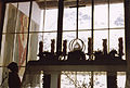
Wattenberg, parish of the court chapels
Chapel in the Wattentaler Lizum

Historic iron ore mining
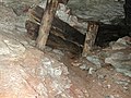
Historic iron ore mining


economy
At an altitude of 2500 m above sea level. A. , the oldest iron mine in North Tyrol was opened in the Wattenberger Mölstal in 1315. The smelting was in the area of today's paper mill cotton wool . Water and hydropower from the municipality of Wattenberg was the reason for the establishment of industrial companies with world renown, such as Swarovski and cotton wool, in Wattens, which has blossomed into a market town on the valley floor of the Inn Valley.
politics
The last mayor elections took place on May 18, 2014, and Franz Schmadl was elected mayor.
The last municipal council elections took place on March 14, 2010.
| Political party | percent | be right | Seats on the local council | Coupling |
|---|---|---|---|---|
| Mayor list | 46.20% | 225 | 5 | |
| Wattenberg citizens' list | 37.78% | 184 | 4th | |
| Freedom Wattenberger | 16.02% | 78 | 2 |
coat of arms
The municipal coat of arms of Wattenberg shows a schoolchild on Zweiberg, since from 1756 to 1905 the Unterlechen school in Wattenberg was attended by children from both sides of the valley. A schoolmaster was teaching in Wattenberg as early as 1524, based on the coat of arms with the young person. The municipality of Wattenberg also took this peculiarity into account in maintaining the multi-class village school with upper level, which - thanks to the understanding of the school authorities - there is currently no second in Austria.
Personalities
Sons and daughters of the church
- Rudolf Schwaiger (1920–1986), politician ( ÖVP )
Web links
- 70366 - Wattenberg. Community data, Statistics Austria .
- Tyrol Atlas
- Wattenberg , in the history database ofthe association "fontes historiae - sources of history"
- Municipality of Wattenberg: Official website of the municipality in the Hall-Wattens region
Individual evidence
- ↑ Franz Schmadl mayor of Wattenberg , Tirol ORF Online, accessed on May 18, 2014
City: Hall in Tirol . Market communities: Fulpmes • Matrei am Brenner • Steinach am Brenner • Völs • Wattens • Zirl . Municipalities: Absam • Aldrans • Ampass • Axams • Baumkirchen • Birgitz • Ellbögen • Flaurling • Fritzens • Gnadenwald • Götzens • Gries am Brenner • Gries im Sellrain • Grinzens • Gschnitz • Hatting • Inzing • Kematen in Tirol • Kolsass • Kolsassberg • Lans • Leutasch • Mieders • Mils • Mühlbachl • Mutters • Natters • Navis • Neustift im Stubaital • Oberhofen im Inntal • Obernberg am Brenner • Oberperfuss • Patsch • Pettnau • Pfaffenhofen • Pfons • Polling in Tirol • Ranggen • Reith bei Seefeld • Rinn • Rum • St. Sigmund im Sellrain • Scharnitz • Schmirn • Schönberg im Stubaital • Seefeld in Tirol • Sellrain • Sistrans • Telfes im Stubai • Telfs • Thaur • Trins • Tulfes • Unterperfuss • Vals • Volders • Wattenberg • Wildermieming .