
Wattentaler Lizum
Coordinates: 47 ° 10 ′ 21 ″ N , 11 ° 38 ′ 16 ″ E

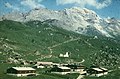
The Wattentaler Lizum (popularly also Wattener Lizum ) describes the eastern end of the valley of the Wattental , which branches off from the Lower Inn Valley at Wattens . Lizum means 'alpine pasture at the head of the valley' in Tyrol, the Wattentaler Lizum is located in the area of the municipality of Wattenberg .


Lizum-Walchen military training area
The Lizum-Walchen military training area is the second largest military training area in Austria with over 50 km² after the Allentsteig military training area (approx. 157 km²). It includes the area of the Wattentaler Lizum and the neighboring Mölstal to the west . It is subordinate to the Austrian Armed Forces and serves up to 40,000 soldiers per year for military alpine training. In 1410 m height which is in the military training area bearing Walchen and four kilometers to the south to 1,995 m , the warehouse Lizum .
Lizum high camp (historical photo)

Development

From 1938/40 the supply of the camp was carried out via a 10.377 km long material cable car that ran from Fritzens station to the Walchen camp. The cable car was dismantled in 1951/52 after the road was built.
Tourist development

The Wattentaler Lizum is the starting point for hikes and ski tours with relatively gentle, but partly avalanche-prone slopes in the mountain range. The area is ideal for professional alpine training all year round because of its large number of runs (depending on snow conditions) and peaks as well as the existing infrastructure (civil and military). During military exercises, the area is sometimes somewhat restricted. On shooting days, hikers must have passed the control post by 8:30 a.m. or 10:00 a.m. and left restricted areas.
The Lizumer Hut ( 2019 m ), which was completely renovated in 2006/07 by the Haller Alpenverein, is located in the Lizum in Wattental . The Alpine Club Hut is located at the intersection of international long-distance hiking routes: Via Alpina , Eagle Walk, Dream Path Munich-Venice , Olympiaweg Garmisch-Innsbruck-Cortina, Zentralalpenweg 02A , Glungezer & Geier-Weg 315 .
Neighboring huts are the Glungezerhütte (8 hours), the Tuxerjochhaus and the Weidener Hütte .
Summit Mass

Traditionally, there is a summit mass on the Mölsberg on the first Sunday after the Assumption of Mary . This is usually celebrated at the summit cross at 11:30 a.m., in bad weather, however, at 11:00 a.m. in the Christkönig Chapel in the Lizum. On this day, the Lizum military training area, which is otherwise closed to private car traffic, is open for cars with Tyrolean license plates (on designated paths, only multi-lane vehicles, no quads) until 10:30 a.m.
Lizum Christ the King Chapel

Web links
- Shooting times at the Lizum Walchen military training area (Wattenberg municipal office)
- Ski & mountain tours in the Lizum in the Wattental
- OeAV Hall in Tirol
Individual evidence
- ↑ June 11, 1952, fire on a cable car pillar (presumably during dismantling work). http://www.feuerwehr-wattens.org/?page_id=1228 Chronicle of the volunteer fire brigade of the market town of Wattens
- ↑ Lizum / Walchen military training area - hiking maps and GPS data for download
- ↑ Truppenübungsplatz - shooting times on Truppenübungsplatz Lizum Walchen , community Wattenberg