
Gschnitz
|
Gschnitz
|
||
|---|---|---|
| coat of arms | Austria map | |
 |
|
|
| Basic data | ||
| Country: | Austria | |
| State : | Tyrol | |
| Political District : | Innsbruck country | |
| License plate : | IL | |
| Surface: | 59.18 km² | |
| Coordinates : | 47 ° 3 ' N , 11 ° 21' E | |
| Height : | 1242 m above sea level A. | |
| Residents : | 438 (January 1, 2020) | |
| Population density : | 7.4 inhabitants per km² | |
| Postal code : | 6150 | |
| Area code : | 05276 | |
| Community code : | 7 03 17 | |
| NUTS region | AT332 | |
| Address of the municipal administration: |
Hno. 101 6150 Gschnitz |
|
| Website: | ||
| politics | ||
| Mayor : | Christian fields | |
|
Municipal Council : (2016) (11 members) |
||
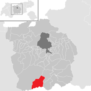
| Location of Gschnitz in the Innsbruck-Land district | ||
  |
||
 Gschnitztal near Gasthaus Feuerstein in the background Kalkwand , Illmspitzen and Kirchdach |
||
| Source: Municipal data from Statistics Austria | ||


Gschnitz is a municipality with 438 inhabitants (as of January 1, 2020) in the Innsbruck-Land district in Tyrol ( Austria ). The municipality is located in the judicial district of Innsbruck .
geography
Gschnitz is located in the rear part of the Gschnitztal , which flows into the Wipptal near Steinach am Brenner . The municipality extends to the end of the valley (with the 3277 m high Habicht ) and forms the border to South Tyrol ( Italy ) in the south .
In contrast to the neighboring municipality of Trins, the municipality consists of widely scattered individual courtyards, some of which are decorated with baroque paintings. The brisk construction activity in the last few decades led to a densification of the settlement.
Neighboring communities
| Neustift in the Stubai Valley | Trins | |
.svg)
|
||
|
Brenner (South Tyrol) Obernberg am Brenner |
history
Gschnitz was first in 1288 in the Tyrolean Urbar by Count Meinhard II. As "Gasnitz" mentioned. In the high Middle Ages the place consisted of individual farms; It was not until the 18th century that a hamlet developed around the parish church (converted into a rococo building by Franz de Paula Penz in 1755 ) with today's center. Gschnitz has been an independent municipality since 1811.
In February and March 1970 the site was reached by avalanches, some of which caused serious damage to property.
Population development

politics
The last mayoral elections took place at the same time as the municipal council elections on March 14, 2010.
Christian Felder was the only candidate and was elected mayor.
This place also gives its name to the Gschnitztal valley of the same name.
Culture and sights
- Parish Church of Our Lady Maria Schnee
- Pilgrimage chapel St. Magdalena in Trins
- War memorial chapel
- Prangerkapelle
- Calves Chapel
- Farmhouses
tourism
The community of Gschnitz belongs to the association area of the Wipptal tourism association. In addition to the only hotel (Hotel Kirchdach), there are two other inns (Feuerstein, Alpenrose) and the Laponesalm at the head of the valley, which can be reached on foot or by taxi.
summer
Like Trins, alpine mountain tourism and the managed mountain huts ( Innsbrucker Hütte , Bremer Hütte , Austrian Tribulaunhütte / Tribulaunhaus) are particularly influential in summer tourism. The Gschnitztal hut tour leads in 6 stages (5 huts) around the Gschnitztal . A popular excursion destination is the "Living Mill Village", where the way people work is shown as it was 100 years ago. Several hydropower- powered flour mills stand next to each other like a village . There are guided tours on request. The sand waterfall near Mühlendorf has a positive health effect on the respiratory organs, which has even been scientifically proven.
Another destination is the pilgrimage church of St. Magdalena with an adjoining snack bar. In the little mountain church there are Romanesque frescoes , which are among the oldest wall paintings in Tyrol. A via ferrata of difficulty level B / C (medium difficulty) has also been leading there since 2017. Above the snack station there is a climbing garden with several climbing routes.
winter
In Gschnitz there are some trails that can be used free of charge. A cleared winter hiking trail also leads to the end of the valley to the Feuerstein inn. In addition, this area is known for demanding ski tours.
Personalities
- Manfred Pranger (* 1978), Austrian ski racer
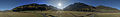
360 ° panorama in the middle of the Gschnitztal
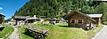
Mill village near Gschnitz

Gschnitztal at Gasthaus Feuerstein Panorama to the south.

Mühlendorf at the end of the Gschnitztal from above

Gschnitztal near GH Feuerstein Panorama to the north

Web links
- Gschnitz municipality in the state of Tyrol
- Gschnitz , in the history database ofthe association "fontes historiae - sources of history"
- 70317 - Gschnitz. Community data, Statistics Austria .
Individual evidence
- ↑ http://tirolatlas.uibk.ac.at/topics/chronicle/query.py/event?place=170317&what=113
- ^ [1] tyrol our country
- ↑ Dehio Tirol 1980 , p. 297f
City: Hall in Tirol . Market communities: Fulpmes • Matrei am Brenner • Steinach am Brenner • Völs • Wattens • Zirl . Municipalities: Absam • Aldrans • Ampass • Axams • Baumkirchen • Birgitz • Ellbögen • Flaurling • Fritzens • Gnadenwald • Götzens • Gries am Brenner • Gries im Sellrain • Grinzens • Gschnitz • Hatting • Inzing • Kematen in Tirol • Kolsass • Kolsassberg • Lans • Leutasch • Mieders • Mils • Mühlbachl • Mutters • Natters • Navis • Neustift im Stubaital • Oberhofen im Inntal • Obernberg am Brenner • Oberperfuss • Patsch • Pettnau • Pfaffenhofen • Pfons • Polling in Tirol • Ranggen • Reith bei Seefeld • Rinn • Rum • St. Sigmund im Sellrain • Scharnitz • Schmirn • Schönberg im Stubaital • Seefeld in Tirol • Sellrain • Sistrans • Telfes im Stubai • Telfs • Thaur • Trins • Tulfes • Unterperfuss • Vals • Volders • Wattenberg • Wildermieming .