
Obernberg am Brenner
|
Obernberg am Brenner
|
||
|---|---|---|
| coat of arms | Austria map | |
 |
|
|
| Basic data | ||
| Country: | Austria | |
| State : | Tyrol | |
| Political District : | Innsbruck country | |
| License plate : | IL | |
| Surface: | 38.68 km² | |
| Coordinates : | 47 ° 1 ' N , 11 ° 25' E | |
| Height : | 1380 m above sea level A. | |
| Residents : | 371 (January 1, 2020) | |
| Population density : | 9.6 inhabitants per km² | |
| Postal code : | 6157 | |
| Area code : | 05274 | |
| Community code : | 7 03 36 | |
| NUTS region | AT332 | |
| Address of the municipal administration: |
Innertal 39a 6157 Obernberg am Brenner |
|
| Website: | ||
| politics | ||
| Mayor : | Josef Saxer (GEFO) (unit list) | |
|
Municipal Council : (2016) (11 members) |
||
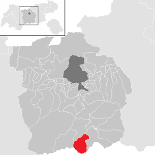
| Location of Obernberg am Brenner in the Innsbruck-Land district | ||
  |
||

|
||
| Source: Municipal data from Statistics Austria | ||

Obernberg am Brenner is a municipality with 371 inhabitants (as of January 1, 2020) in the Innsbruck-Land district in Tyrol ( Austria ). The municipality is located in the judicial district of Innsbruck .
geography
Obernberg is located in the valley of the same name , which branches off from the Wipptal near Gries am Brenner . The head of the valley is formed by the massive black wall and the limestone peaks of the Obernberger Tribulaun in contrast to the primary rock terrain below.
The valley was used as an alpine pasture as early as the Bronze Age , and the invading Romans met in 15 BC. On a flourishing mining industry that was abandoned in the 16th century. The Obernberger See , surrounded by spruce forests, is a popular excursion destination, and Emperor Maximilian I went hunting in the area.
The Obernberger Seebach flows through the community.
Districts
The municipality consists of seven hamlets:
- Guide,
- Outer Valley,
- Innertal,
- Ready,
- Just,
- Frade and
- Obernberger See.
Neighboring communities
| Trins | ||
| Gschnitz |
.svg)
|
Gries on the burner |
|
Brenner ( South Tyrol ) |
Population development

Culture and sights

- Parish Church of St. Nicholas:
After a little church of St. Nicholas was mentioned as early as 1339 , the late Baroque parish church of St. Nicholas was built in 1760. In 1834 it received its characteristic onion dome. The architecture comes from Johann Umhauser, who was an employee of the spiritual building director Franz de Paula Penz. The painter and plasterer Josef Schmutzer the Younger , who also designed the churches in St. Jodok am Brenner , Mittenwald and Oberammergau, was responsible for decorating the church. The rococo style pulpit, like the structure of the altar and the statues, comes from the ideas of Johann Perger from Stilfes . The ceiling frescoes and the altarpiece of the main altar are made by Christoph Anton Mayr from Schwaz . The Stations of the Cross were designed by Josef Strasser in 1850. Thanks to its location on a moraine wall in the valley, with the Tribulaun mountain range in the background, and its architectural style, the church is one of the most sought-after photo opportunities in Tyrol.

The late baroque parish church ...
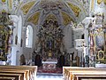
... St. Nicholas from 1760 is hiring ...

... an architectural gem in the ...

... the municipality of Obernberg am Brenner.


_05.JPG)
_01.JPG)
- Chapel of Our Lady by the Lake
- Hofkapelle (also chapel in Innertal or Danler chapel)
- Frader mill
- Obernberger See

politics
The last mayoral elections took place at the same time as the municipal council elections on March 14, 2010.
Roman Grünerbl was elected mayor.
| Political party | percent | be right | Seats on the local council | Coupling |
|---|---|---|---|---|
| Unit list | 51.32% | 136 | 6th | |
| Tyrolean farmers' association + ÖAAB | 34.72% | 92 | 4th | |
| Citizen List | 13.96% | 37 | 1 |
Partner municipality
Obernberg maintains a partnership with Heddesbach in Germany.
coat of arms
The municipal coat of arms awarded in 1973 by the Tyrolean provincial government shows two gold cones and a king with a crown in a three-passport in red . The three golden cones refer to the legend of the golden bowling game , which is said to be buried in the Rasselstein and is guarded by the mountain king. The real core of the legend is probably the natural resources of the Tribulaun.
Personalities
- Joseph Vincenz Hofmann (1800–1863), theologian, was a clergyman in Obernberg
- Heini Messner (* 1939), successful ski world cup racer and trainer of the ÖSV women's team in the 1970s
- Ernst Mair-Tribulaun (* 1928), painter
- Hugo Penz , university professor, geographer
Individual evidence
Web links
- Protected landscape area Nößlachjoch - Obernberger See - Tribulaune
- Obernberg am Brenner , in the history database ofthe association "fontes historiae - sources of history"
- 70336 - Obernberg am Brenner. Community data, Statistics Austria .
City: Hall in Tirol . Market communities: Fulpmes • Matrei am Brenner • Steinach am Brenner • Völs • Wattens • Zirl . Municipalities: Absam • Aldrans • Ampass • Axams • Baumkirchen • Birgitz • Ellbögen • Flaurling • Fritzens • Gnadenwald • Götzens • Gries am Brenner • Gries im Sellrain • Grinzens • Gschnitz • Hatting • Inzing • Kematen in Tirol • Kolsass • Kolsassberg • Lans • Leutasch • Mieders • Mils • Mühlbachl • Mutters • Natters • Navis • Neustift im Stubaital • Oberhofen im Inntal • Obernberg am Brenner • Oberperfuss • Patsch • Pettnau • Pfaffenhofen • Pfons • Polling in Tirol • Ranggen • Reith bei Seefeld • Rinn • Rum • St. Sigmund im Sellrain • Scharnitz • Schmirn • Schönberg im Stubaital • Seefeld in Tirol • Sellrain • Sistrans • Telfes im Stubai • Telfs • Thaur • Trins • Tulfes • Unterperfuss • Vals • Volders • Wattenberg • Wildermieming .