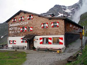
Innsbruck hut
| Innsbrucker Hütte ÖAV hut category I |
||
|---|---|---|
| location | Alfairalpe, Mittleres Gschnitztal ; Tyrol , Austria ; Valley location: Gschnitz | |
| Mountain range | Stubai Alps | |
| Geographical location: | 47 ° 2 '35 " N , 11 ° 18' 38" E | |
| Altitude | 2369 m above sea level A. | |
|
|
||
| owner | ÖAV - Section Tourist Club Innsbruck | |
| Built | 1884, expanded in 1894, total renovation in 1934 and new building after 1945, renovation and expansion in 1982 | |
| Construction type | hut | |
| Development | Material ropeway | |
| Usual opening times | Late June to late September | |
| accommodation | 30 beds, 100 camps | |
| Winter room | 12 bearings | |
| Web link | Innsbruck hut | |
| Hut directory | ÖAV DAV | |
The Innsbrucker Hütte is an alpine refuge in the Stubai Alps at an altitude of 2369 m above sea level. A. in the middle Gschnitztal , not far from the Pinnisjoch. It is administered by the Innsbruck Tourist Club section of the Austrian Alpine Club . The Innsbrucker Hütte is located below the Habicht on the Stubai High Trail and is therefore frequently visited.
history
In May 1884 the Innsbruck Tourist Club acquired 800 m² of land on the Alfair-Alpe. A brick hut with a 7.5 × 5.5 m room was built on top of it, which offered space for 10 people on mattresses and 20 on hay. Since the hut quickly became a popular destination for mountaineers, plans were made to enlarge it soon after completion. The expansion plans were presented at the Tyrolean State Exhibition in 1891, and the extension was inaugurated in 1894. With the opening of the Stubai Valley Railway in 1904, the journey to the Stubai Valley was made much easier, and the number of hut guests continued to rise. The expansion was prevented by the First World War . The building fabric was badly damaged by break-ins and devastation in the time of need after the war. The number of visits increased again, in 1924 1,600 guests were counted, in 1934 more than 3,000. That year the hut was completely renovated.
As a result of the Second World War, the hut was almost completely destroyed in 1945. The restoration will be followed by further expansions and improvements. In 1953/54 a diesel generator was purchased for power supply and a small hydropower plant was built. Increasing visitor numbers led to the expansion of the attic. A material ropeway was built for further expansion . In 1982 the hut was again generously rebuilt and expanded.
ways

Approach
The fastest way to get to the Innsbrucker Hütte from the Gschnitztal is from the parking lot behind the Gasthof Feuerstein ( 1281 m ). This ascent takes about three hours, with over 1000 meters of altitude to be overcome. Another path leads from the Stubai Valley of Neder ( 970 m ) through the Pinnistal in about 4 to 5 hours to the hut, past four (former) alpine pastures (Herzebenalm, Issenangeralm, Pinnisalm, Karalm); You can take a (regular) taxi to the Karalm ( 1747 m ).
Mountaineering
- Habicht ( 3277 m ), walking time 3 hours
- Glättespitze ( 3133 m ), walking time 3 hours
- Kalkwand ( 2564 m ), walking time 1 hour
- Ilmspitze ( 2692 m ) with moderately difficult via ferrata, walking time 3 hours
Transitions to other huts
- to the Bremer Hütte in 6 to 7 hours
- to the Elferhütte in 3 to 4 hours via the Pinnisjoch and the Panoramaweg or the Elferspitze
Web links
- Ascent to the Innsbrucker Hütte via the Pinnistal
- Innsbrucker Hütte in the historical Alpine archive of the Alpine associations in Germany, Austria and South Tyrol (temporarily offline)


