
Kirchdachspitze
| Kirchdachspitze | ||
|---|---|---|
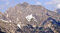
 Church roof over the Pinnistal |
||
| height | 2840 m above sea level A. | |
| location | Tyrol , Austria | |
| Mountains | Stubai Alps | |
| Dominance | 4.2 km → Habicht | |
| Notch height | 470 m ↓ Pinnisjoch | |
| Coordinates | 47 ° 4 '4 " N , 11 ° 20' 33" E | |
|
||
| rock | Main dolomite | |
| Age of the rock | Norium | |
| Normal way | from the Padasterjochhaus | |

The church roof , also Kirchdachspitze , is 2840 m above sea level. A. high mountain in the Stubai Alps in Tyrol , Austria .
As the highest point in the Serleskamm , which separates the Gschnitztal in the southeast from the Pinnis and Stubaital in the northwest, it lies between the 2692 m high Ilmspitze in the southwest and the 2641 m high Hammerspitze in the northeast.
From the west, the Kirchdach can be reached from the Pinnisalm ( 1560 m ) in the Pinnistal via the Jubiläumssteig in approx. 4 hours. From the Issenangeralm ( 1366 m ), also located in the Pinnistal, the Rohrauersteig leads in about 4 hours from the north to the summit. From the Gschnitztal valley, the Padasterjochhaus ( 2232 m ) north-east of the church roof serves as a base; the ascent from there takes about 2 hours.
All paths run from the Silbersattel ( 2750 m ) over the north ridge, partially exposed, and cover the last 90 meters in altitude up to the summit.
A variety of challenging climbing routes lead through the wild north and north-west walls, all of which are rarely repeated. Andreas Orgler was an important redeveloper for these walls in the 1980s. He also opened many ice and mixed climbing routes .

Kirchdachspitze from the northeast

partially insured north ridge
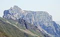
Church roof from the south
From the southwest


literature
- Heinrich and Walter Klier : Alpine Club Guide Stubai Alps . Rother Bergverlag, Munich 1980, ISBN 3-7633-1212-9 , p. 281-285 .
Web links
- Kirchdach on Summitpost.org
Individual evidence
- ↑ Andreas Orgler: Climbing in the Stubai Alps and in the Valsertal Basin . Panico Alpinverlag, 1992, ISBN 978-3-926807-21-2 , p. 218-231 .