Kinsau
| coat of arms | Germany map | |
|---|---|---|

|
Coordinates: 47 ° 53 ' N , 10 ° 54' E |
|
| Basic data | ||
| State : | Bavaria | |
| Administrative region : | Upper Bavaria | |
| County : | Landsberg am Lech | |
| Management Community : | Reichling | |
| Height : | 699 m above sea level NHN | |
| Area : | 11.44 km 2 | |
| Residents: | 1043 (Dec. 31, 2019) | |
| Population density : | 91 inhabitants per km 2 | |
| Postal code : | 86981 | |
| Area code : | 08869 | |
| License plate : | LL | |
| Community key : | 09 1 81 129 | |
| Address of the municipal administration: |
Kirchweg 4 86981 Kinsau |
|
| Website : | ||
| Mayor : | Marco Dollinger | |
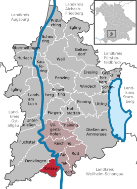
| Location of the municipality of Kinsau in the Landsberg am Lech district | ||
Kinsau is a municipality in the Upper Bavarian district of Landsberg am Lech and a member of the Reichling administrative community .
Geographical location
Kinsau is located on the southern edge of the Landsberg am Lech district between the Romantic Road and the Lech . The community area slopes down to the Lech in four terraced steps and offers some splendid views.
Kinsau has no other parts of the community .
The lowest point of the community is at 642 on the Lech, the highest at 766 m in the Sachsenrieder forest .
history
Until the church is planted
Kinsau is mentioned for the first time as Kunigesow in 1323 as part of the rule Peißenberg , Amt Landsberg . After the Seefelds died out around 1420, Kinsau went to the Lords of Freyberg, who sold it to the Schongau hospital in 1445 . In 1818 the community was founded, which belonged to the district court Schongau .
Administrative affiliation
Until the district reform , which came into force on July 1, 1972, Kinsau was part of the Schongau district . Since then it has belonged to the Landsberg am Lech district .
Kinsau has been part of the Reichling administrative community since 1978 .
Population development
- 1445: 160 inhabitants (approximate information)
- 1961: 666 inhabitants
- 1970: 697 inhabitants
- 1991: 848 inhabitants
- 1995: 893 inhabitants
- 2005: 993 inhabitants
- 2010: 1041 inhabitants
- 2015: 1048 inhabitants
- 2018: 1044 inhabitants
- 2019: 1043 inhabitants
Between 2008 and 2019 the municipality grew from 801 to 1043 by 242 inhabitants or by 30.2%.
politics
Municipal council
After the local elections, the local council consists of 12 members. All of them belong to the Kinsau list.
mayor
- 1966–1976: Max Wagner
- 1976–1990: Heinrich Dollinger
- 1990-2002: Michael Linder
- 2002–2014: Hermann Reinhard
- since 2014: Marco Dollinger
Culture and sights
The parish church of St. Matthew, built by Thomas Natter at the beginning of the 18th century, and the parsonage belonging to it are worth seeing .
The first cogwheel railway in Bavaria , the factory railway of the Kinsau wood pulp factory , was used to transport wood from 1907 to 1929, the railway line is still partially visible. This rack railway used to have a connection to the Landsberg am Lech – Schongau railway line .
The castle restaurant is also known with its two oriel turrets and onion domes on both sides of the north gable.
At the school there is a 110-year-old linden tree with a circumference of more than 5.60 meters.
On the Lech there is Lech barrier 8a - Kinsau .
See also: List of architectural monuments in Kinsau
Soil monuments
See: List of ground monuments in Kinsau
Web links
- The official website of the municipality of Kinsau
- Entry on the coat of arms of Kinsau in the database of the House of Bavarian History
Individual evidence
- ↑ "Data 2" sheet, Statistical Report A1200C 202041 Population of the municipalities, districts and administrative districts 1st quarter 2020 (population based on the 2011 census) ( help ).
- ^ Community of Kinsau in the local database of the Bavarian State Library Online . Bavarian State Library, accessed on September 8, 2019.
- ↑ Archived copy ( memento of the original from March 30, 2017 in the Internet Archive ) Info: The archive link was inserted automatically and has not yet been checked. Please check the original and archive link according to the instructions and then remove this notice.
- ↑ Archived copy ( memento of the original from March 26, 2017 in the Internet Archive ) Info: The archive link was inserted automatically and has not yet been checked. Please check the original and archive link according to the instructions and then remove this notice.
- ↑ Peter Rasch: The branch lines between Ammersee, Lech and Wertach. With the Ammerseebahn, Pfaffenwinkelbahn & Co around the Bavarian Rigi . EOS Verlag, St. Ottilien 2011, 384 pages, color illustrations, ISBN 978-3-8306-7455-9 , pp. 244–248


