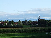
Thaining
| coat of arms | Germany map | |
|---|---|---|

|
Coordinates: 47 ° 58 ' N , 10 ° 57' E |
|
| Basic data | ||
| State : | Bavaria | |
| Administrative region : | Upper Bavaria | |
| County : | Landsberg am Lech | |
| Management Community : | Reichling | |
| Height : | 688 m above sea level NHN | |
| Area : | 8.71 km 2 | |
| Residents: | 1044 (Dec. 31, 2019) | |
| Population density : | 120 inhabitants per km 2 | |
| Postal code : | 86943 | |
| Area code : | 08194 | |
| License plate : | LL | |
| Community key : | 09 1 81 142 | |
| Address of the municipal administration: |
Dorfplatz 1 86943 Thaining |
|
| Website : | ||
| Mayor : | Leonhard Stork (village community) | |
| Location of the municipality of Thaining in the Landsberg am Lech district | ||
Thaining is a municipality in the Upper Bavarian district of Landsberg am Lech and a member of the Reichling administrative community .
geography
Thaining is located in the Munich region , about 15 kilometers west of the Ammersee .
There is only the district Thaining. There are no other parts of the community apart from the main town. The hamlet of Ziegelstadel is not an officially named part of the municipality.
The lowest point of the community is at 655 m on the Hauser Bach , the highest at 718 m north of the mountain chapel.
history
Thaining was first mentioned in 1083 in a deed of donation to Habach Abbey .
From the 11th century onwards, the Lords of Taningen were mentioned as a local nobility, who included an abbot from Wessobrunn , a district judge from Landsberg and a sea judge from Dießen . The family living on the Ödenburg finally died out at the beginning of the 16th century.
After the local nobility died out, the landlords included the Hl. Geist Spital Landsberg, the electoral fiefdom, the parish church of St. Martin, the monasteries of Dießen and Wessobrunn, the churches of Hechenwang and St. Wolfgang, the community of Thaining, the Jesuit college in Landsberg, the electoral college Kastenamt Landsberg, the Hofmark Igling, the Wirtstafern Thaining, the church Sandau, as well as the Spital Weilheim.
Thaining belonged to the Rentamt München and the Landsberg Regional Court of the Electorate of Bavaria .
Population development
Between 1988 and 2019 the municipality grew from 837 to 1,044 by 207 inhabitants or 24.7%.
- 1970: 629 inhabitants
- 1987: 846 inhabitants
- 1991: 890 inhabitants
- 1995: 897 inhabitants
- 2000: 892 inhabitants
- 2005: 918 inhabitants
- 2010: 911 inhabitants
- 2015: 972 inhabitants
- 2018: 1047 inhabitants
- 2019: 1044 inhabitants
politics
mayor
Leonhard Stork has been mayor since May 1, 2008.
coat of arms
The description of the coat of arms reads: A black mill wheel floating in silver over a green Dreiberg.
Architectural and ground monuments
See also: List of Architectural Monuments in Thaining and List of Ground Monuments in Thaining
- Catholic parish church of St. Martin
- Filial church St. Wolfgang
- Rectory
Economy and Infrastructure
Economy including agriculture and forestry
In 1998, according to official statistics, there were no employees at the place of work in the manufacturing sector 34 and in the trade and transport sector. In other economic sectors 45 people were employed at the place of work subject to social security contributions. There were a total of 293 employees at the place of residence subject to social security contributions. There was one company in the manufacturing sector and two companies in the main construction sector. In addition, in 1999 there were 30 farms with an agriculturally used area of 497 ha, of which 307 ha were permanent green space.
education
The following institutions exist (as of: 1999):
- Kindergarten with 25 places
Personalities
- Hugo Sperrle (1885–1953), General Field Marshal of the Air Force , Commander in Chief of Air Fleet 3 during World War II ; lived in training after the end of the war
- Carolina Hoffmann (* 1992), actress born in Thaining
Web links
- Entry on the coat of arms of Thaining in the database of the House of Bavarian History
Individual evidence
- ↑ "Data 2" sheet, Statistical Report A1200C 202041 Population of the municipalities, districts and administrative districts 1st quarter 2020 (population based on the 2011 census) ( help ).
- ^ Community Thaining in the local database of the Bayerische Landesbibliothek Online . Bavarian State Library, accessed on September 7, 2019.
- ^ Heide Weißhaar – Kiem: Landsberg am Lech district . Ed .: Landsberg am Lech district. 1st edition. EOS Verlag Sankt Ottilien, 2010, ISBN 978-3-8306-7437-5 , p. 283 .


