Egling on the couple
| coat of arms | Germany map | |
|---|---|---|

|
Coordinates: 48 ° 11 ' N , 10 ° 59' E |
|
| Basic data | ||
| State : | Bavaria | |
| Administrative region : | Upper Bavaria | |
| County : | Landsberg am Lech | |
| Height : | 552 m above sea level NHN | |
| Area : | 20.77 km 2 | |
| Residents: | 2357 (Dec. 31, 2019) | |
| Population density : | 113 inhabitants per km 2 | |
| Postal code : | 86492 | |
| Area code : | 08206 | |
| License plate : | LL | |
| Community key : | 09 1 81 116 | |
| Community structure: | 3 parts of the community | |
| Address of the municipal administration: |
Hauptstrasse 31 86492 Egling adPaar |
|
| Website : | ||
| Mayor : | Ferdinand Holzer ( CSU ) | |
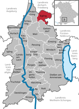
| Location of the municipality of Egling adPaar in the Landsberg am Lech district | ||
Egling an der Paar (officially: Egling adPaar ) is a municipality in the Upper Bavarian district of Landsberg am Lech .
Community structure
Parts of the municipality are the parish village Egling an der Paar, the church village Heinrichshofen and the hamlet Hattenhofen . There are the districts Egling an der Paar and Heinrichshofen.
history
Until the church is planted
Several burial mounds in the municipality indicate that the first settlement was in the Hallstatt period , but today's village dates back to the conquest in the 6th century. Presumably the village consisted of only one farm at that time, today's Frietingerhof.
Egling is first mentioned in a document in 1133.
Unter- and Oberegling initially only consisted of four farmsteads and one mill, but by dividing farms and the settlement of small farmers, the two places developed into villages from the 12th century onwards.
The parish seat was in Unteregling, already in the Middle Ages Unter- and Oberegling including Hattenhofen counted 123 families.
Egling an der Paar belonged to the Munich Rent Office and to the Landsberg Regional Court of the Electorate of Bavaria . In the course of the administrative reforms in Bavaria, today's municipality was created with the municipal edict of 1818 .
Incorporations
On July 1, 1971, the previously independent community of Heinrichshofen was incorporated.
Population development
Between 1988 and 2019 the municipality grew from 1,595 to 2,357 by 762 inhabitants or 47.8%.
- 1970: 1413 inhabitants
- 1987: 1543 inhabitants
- 1991: 1803 inhabitants
- 1995: 1838 inhabitants
- 2005: 2210 inhabitants
- 2010: 2253 inhabitants
- 2015: 2247 inhabitants
- 2016: 2284 inhabitants
- 2018: 2312 inhabitants
- 2019: 2357 inhabitants
politics
mayor
- First Mayor (since May 2014): Ferdinand Holzer (CSU / Bürgergemeinschaft)
- Former Mayor (since May 2014): Leonhard Wörl (CSU / Bürgergemeinschaft)
- Former Mayor (since 2002): Friedrich Kircher sen. (CSU / community of citizens)
Municipal council
| year | CSU / BG | SPD | DG | WGH | BP | ÖDP | total | voter turnout |
|---|---|---|---|---|---|---|---|---|
| 2014 | 5 | 0 | 3 | 2 | 2 | 2 | 14th | 74.29% |
| 2008 | 5 | 0 | 4th | 3 | 2 | x | 14th | is missing |
| 2002 | 5 | 1 | 4th | 3 | 1 | x | 14th | 78.4% |
BG = community of citizens
DG = village community of Egling-Heinrichshofen
WGH = community of voters Heinrichshofen
coat of arms
The coat of arms description reads: In red a three-pronged, upright silver ger.
Community partnerships
Since 1990 there has been a community partnership with the French community of Foussais-Payré, which has 1200 inhabitants, in the Vendée department in the Pays de la Loire region .
Economy and Infrastructure
Economy including agriculture and forestry
In 1998, according to official statistics, there were no employees subject to social insurance contributions in the manufacturing industry 83 and in the trade and transport sector. In other economic sectors, 86 people were employed at the place of work subject to social security contributions. There were 561 employees at the place of residence subject to social security contributions. There were three companies in manufacturing and seven in construction. In addition, in 1999 there were 43 farms with an agriculturally used area of 1633 ha, of which 1507 ha were arable land and ha were permanent green space.
traffic
Rail transport
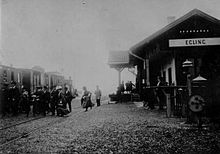
On the western outskirts of Egling, the single-track Ammerseebahn runs from Mering via Geltendorf and Dießen to Weilheim . It is managed by Deutsche Bahn as the route book route 985. Egling train station is located on the Ammerseebahn in the north of Egling . Today, along with the neighboring Walleshausen station, it is the only station in the northern section of the line where train crossings are still possible. Today the station has two platform tracks. The continuous main track is on an intermediate platform , the overtaking track is on the house platform . There is also a loading track that was closed in 2000 when the points were expanded. In order to be able to accommodate diverted ICE trains, the passing track is 609 meters long.
The Ammerseebahn was opened on June 30, 1898 by the Royal Bavarian State Railways . The Egling train crossing station was built on it. The station received a one-story brick reception building with wooden paneling in the local railway style. In 1940 the building was rebuilt and wooden paneling was removed. In addition to the service and waiting rooms, there was also a goods hall in the reception building. The Ammerseebahn between Mering and Geltendorf was electrified by September 7, 1970. In 1987 the loading facility for the transport of sugar beet was dismantled on the loading platform. Until 1993 the station was regularly served by freight traffic.
The station has been served every hour since 2008 by trains of the Bayerische Regiobahn (BRB) from Augsburg-Oberhausen to Schongau . In the rush hour , individual amplifier trains run between Augsburg and Geltendorf. All trains that run on the route serve the station. From 1980 to 1982 the express train E 2682, which ran from Augsburg as the express train D 782 to Hamburg-Altona , stopped in Egling. Long-distance trains have not been running on the Ammerseebahn since 1991 .
Bus transport
Egling is connected to the Landsberger Verkehrsgemeinschaft (LVG), in which the rail traffic is not integrated. The LVG bus line 60 runs daily through Egling and the Heinrichshofen district of Egling from Heinrichshofen via Egling, Walleshausen , Kaltenberg , Weil and Penzing to Landsberg am Lech . Since December 2017, Egling has been connected to the MVV by bus route 828 to Grafrath.
education
In 2009 the following institutions existed:
- House of the child (crèche, kindergarten, day-care center)
- primary school
Architectural and ground monuments
See: List of architectural monuments in Egling an der Paar and List of ground monuments in Egling an der Paar
Sons and daughters of the church
- Gottfried Sieber (* 1940), German Benedictine abbot
Web links
- Homepage of the municipality of Egling adPaar
- Eglinger and Heinrichshofener historical house book by Pankraz Fried
- Entry on the coat of arms of Egling an der Paar in the database of the House of Bavarian History
- Egling an der Paar: Official statistics of the LfStat
- Community portal of the community Egling adPaar / Heinrichshofen
Individual evidence
- ↑ "Data 2" sheet, Statistical Report A1200C 202041 Population of the municipalities, districts and administrative districts 1st quarter 2020 (population based on the 2011 census) ( help ).
- ^ Community Eching am Ammersee in the local database of the Bavarian State Library Online . Bavarian State Library, accessed on September 8, 2019.
- ↑ District. Office for Digitization, Broadband and Surveying | Landsberg am Lech with the Starnberg branch, accessed on April 10, 2019 .
- ^ Heide Weißhaar – Kiem: Landsberg am Lech district . Ed .: Landsberg am Lech district. 1st edition. EOS Verlag Sankt Ottilien, 2010, ISBN 978-3-8306-7437-5 , p. 185 .
- ^ Heide Weißhaar-Kiem: Landsberg am Lech district . Ed .: Landsberg am Lech district. 1st edition. EOS Verlag St. Ottilien, 2010, ISBN 978-3-8306-7437-5 , p. 184-185 .
- ^ Wilhelm Volkert (ed.): Handbook of Bavarian offices, communities and courts 1799–1980 . CH Beck, Munich 1983, ISBN 3-406-09669-7 , p. 507 .
- ^ Andreas Janikowski: The Ammerseebahn. Traffic development in western Upper Bavaria . Transpress, Stuttgart 1996, ISBN 3-344-71033-8 , pp. 13-14 .
- ^ Andreas Janikowski: The Ammerseebahn. Traffic development in western Upper Bavaria . Transpress, Stuttgart 1996, ISBN 3-344-71033-8 , pp. 83-86 .
- ^ Andreas Janikowski: The Ammerseebahn. Traffic development in western Upper Bavaria . Transpress, Stuttgart 1996, ISBN 3-344-71033-8 , pp. 40 .
- ↑ Description of the Egling train station ( Memento of the original from April 9, 2013 in the Internet Archive ) Info: The archive link was inserted automatically and has not yet been checked. Please check the original and archive link according to the instructions and then remove this notice. on Ammerseebahn.de
- ^ Andreas Janikowski: The Ammerseebahn. Traffic development in western Upper Bavaria . Transpress, Stuttgart 1996, ISBN 3-344-71033-8 , pp. 94 .
- ↑ Line network of the Landsberger Verkehrsgemeinschaft ( Memento of the original from December 3, 2015 in the Internet Archive ) Info: The archive link was automatically inserted and not yet checked. Please check the original and archive link according to the instructions and then remove this notice. (PDF; 69 kB) on lvg-bus.de


