Pürgen
| coat of arms | Germany map | |
|---|---|---|

|
Coordinates: 48 ° 2 ′ N , 10 ° 55 ′ E |
|
| Basic data | ||
| State : | Bavaria | |
| Administrative region : | Upper Bavaria | |
| County : | Landsberg am Lech | |
| Management Community : | Pürgen | |
| Height : | 648 m above sea level NHN | |
| Area : | 21.99 km 2 | |
| Residents: | 3552 (Dec. 31, 2019) | |
| Population density : | 162 inhabitants per km 2 | |
| Postal code : | 86932 | |
| Area code : | 08196 | |
| License plate : | LL | |
| Community key : | 09 1 81 141 | |
| Community structure: | 4 parts of the community | |
| Address of the municipal administration: |
Weilheimer Strasse 2 86932 Pürgen |
|
| Website : | ||
| Mayor : | Klaus Flüß (village community) | |
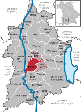
| Location of the municipality of Pürgen in the Landsberg am Lech district | ||
Pürgen is a municipality in the Upper Bavarian district of Landsberg am Lech and a member of the Pürgen administrative community .
geography
Pürgen is located near the city of Landsberg in the Munich planning region .
The municipality has four officially named municipal parts (the type of settlement is given in brackets ):
- Lengenfeld ( Kirchdorf )
- Pürgen ( parish village )
- Stoffen (parish village)
- Ummendorf (Kirchdorf)
The four places also form the four demarcations that exist in the municipality.
Pürgen is located in the moraine landscape on the Lechhocherrasse . Part of the village lies on the northern slope of the Kapellenberg, the remaining part in the valley basin at the foot of the three hills: the Kapellenberg, the Mühlberg and the Diensberg. In the middle of the village is the village pond without a direct inflow . State road 2057 Landsberg - Weilheim ran through the town in twelve strikingly sharp bends until the bypass was built .
The Kapellenberg ( 672 m ) is a single hill, called Umlaufberg (also called Lueg ins Land ), and bears witness to the loop of the river in a last ice-age meltwater valley. From this elevation there is a beautiful view of the area and the Alpine chain - especially in foehn weather .
The municipal area extends from 601 m on the Lech to 686 m west of Hagenheim .
history
Until the church is planted
The first cultural development began for the area around Pürgen in the older Iron Age or Hallstatt Age , around 1000 BC. One suspects a larger prehistoric settlement due to the place name, the strategically important location and the city of the dead in the Frauenwald in the southeast of the village. Of the 200 burial mounds alleged to have existed in the past, only 63 were counted in 1908. In the years after the First World War , some endangered hills were examined and cremated and skeletal burials with impressively decorated Hallstatt vessels were uncovered. An ancient Greek bronze basin with small hump beads was added to a grave.
Pürgen formed its own court in the 12th century . The first owners were the purlins , a noble family still living today. They originally had their seat on the Landsberger Schlossberg, the then Castell Phetine with a St. Peter's Chapel. ( The oldest Pfettner is Ortolph de Phetine around 1146 ). Penzing and Pürgen were their oldest possessions. Subsequently, Pürgen was inherited again and again within the family until it was largely burned down after an inheritance dispute in 1833. The village was then rebuilt by free farmers.
In the course of the administrative reforms in the Kingdom of Bavaria , the municipal edict of 1818 created the municipalities of Lengenfeld, Stoffen, Ummendorf and Pürgen.
Incorporation and community merger
On July 1, 1971, the previously independent municipality of Ummendorf was incorporated into the municipality of Stoffen.
On July 1, 1972, the municipalities of Stoffen, Lengenfeld and Pürgen merged to form a new municipality on a voluntary basis as part of the municipal area reform. This was initially called Stoffen , but was renamed Pürgen on May 22, 1973 .
Castle of Pürgen
According to ancient traditions, there was a castle in Pürgen . Most of the old castle burned down during the Swedish War. Around 1700 the castle was described in the Topographia von Wening (like Meichelberg also historian) as "an ancient, dilapidated building, but surrounded by a moat". In the 18th century it was rebuilt with a castle chapel , well-vaulted cellars, eleven rooms and a hall. In addition to sizable arable and meadow land, the property included 425 days of forest. The new building enjoyed great admiration thanks to its pleasing shape on the south side of the village pond. The oldest cadastral folder from around 1810 shows an east-west facing main building with two elongated farm buildings standing at right angles. In 1835, the entire building was demolished except for the horse stable. Only a plaque on the new house on the site of the castle reminds of the former site.
Origin of the word Pürgen
The oldest spelling is around 740 Piringa in “Monumenta Germaniae”, 1033 Pirigen . A historian named Meichelbeck wrote in his Archivum Benedictoburanum in 1708 : "Pirgen, that one sometimes also writes Birgau". The terms of that time changed over the course of time to the familiar Pürgen.
Population development
Between 1988 and 2018 the municipality grew from 2,285 to 3,548 by 1,263 inhabitants or 55.3%.
- 1961: 1730 inhabitants, of which 410 in Lengenfeld, 590 in Pürgen and 730 in Stoffen (with Ummendorf)
- 1970: 1857 inhabitants, thereof 467 in Lengenfeld, 658 in Pürgen and 732 in Stoffen (with Ummendorf)
- 1987: 2241 inhabitants
- 1991: 2441 inhabitants
- 1995: 2554 inhabitants
- 2000: 2757 inhabitants
- 2005: 3149 inhabitants
- 2010: 3306 inhabitants
- 2013: 3365 inhabitants, of which 795 in Lengenfeld, 1500 in Pürgen, 594 in Stoffen and 476 in Ummendorf
- 2015: 3476 inhabitants
politics
mayor
- 1990 to 2002 Wilhelm Niedermeyer
- 2002 to 2020 Klaus Flüß
- since 2020 Wilfried Lechler
Municipal council
| year | DG Pürgen | DG fabrics | DG Lengenfeld | DG Ummendorf | total | Voter turnout in% |
|---|---|---|---|---|---|---|
| 2014 | 7th | 3 | 4th | 2 | 16 | 60.0 |
| 2008 | 7th | 3 | 4th | 2 | 16 | 63.8 |
| 2002 | 5 | 4th | 3 | 2 | 14th | 67.5 |
DG = village community
The municipal tax receipts in 1999 amounted to the equivalent of € 1,076 thousand, of which the trade tax income (net) amounted to the equivalent of € 114 thousand.
coat of arms
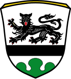
Today's coat of arms , which can be seen on the maypole, got its ministerial approval on May 2, 1960 after it was designed by the district administrator. It is a black bar lowered in silver, striding above a red armored black lion, in the base of the shield a green three-mountain. The coat of arms is based on the local history of the municipality. It is reminiscent of the rule of the purlins , who had their property in Pürgen as early as the 12th century, they formed their own court . The purlin family is still closely associated with Pürgen today. The purlin coat of arms can still be found on several tombstones in the church's tower chapel. The green Dreiberg on Pürgen's coat of arms indicates the Schlossberg and the large group of tumuli at the Frauenwald. At the same time, permission was given to Pürgen to run a municipal flag in three stripes in black / white / green.
Architectural monuments
- Rectory , built in 1747
Soil monuments
See: List of ground monuments in Pürgen
Web links
- Entry on the coat of arms of Pürgen in the database of the House of Bavarian History
Individual evidence
- ↑ "Data 2" sheet, Statistical Report A1200C 202041 Population of the municipalities, districts and administrative districts 1st quarter 2020 (population based on the 2011 census) ( help ).
- ^ Municipality of Pürgen in the local database of the Bavarian State Library Online . Bavarian State Library, accessed on September 7, 2019.
- ^ A b c Wilhelm Volkert (Ed.): Handbook of the Bavarian offices, municipalities and courts 1799–1980 . CH Beck, Munich 1983, ISBN 3-406-09669-7 , p. 507 .
- ^ Federal Statistical Office (ed.): Historical municipality directory for the Federal Republic of Germany. Name, border and key number changes in municipalities, counties and administrative districts from May 27, 1970 to December 31, 1982 . W. Kohlhammer, Stuttgart / Mainz 1983, ISBN 3-17-003263-1 , p. 580 .
- ↑ Information for the districts: Gameinde Pürgen ( Memento of the original from December 19, 2014 in the Internet Archive ) Info: The archive link was inserted automatically and has not yet been checked. Please check the original and archive link according to the instructions and then remove this notice.
- ↑ http://www.wahlen.bayern.de/kommunalwahlen/


