Because (Upper Bavaria)
| coat of arms | Germany map | |
|---|---|---|

|
Coordinates: 48 ° 7 ' N , 10 ° 55' E |
|
| Basic data | ||
| State : | Bavaria | |
| Administrative region : | Upper Bavaria | |
| County : | Landsberg am Lech | |
| Height : | 587 m above sea level NHN | |
| Area : | 44.48 km 2 | |
| Residents: | 3854 (Dec. 31, 2019) | |
| Population density : | 87 inhabitants per km 2 | |
| Postal code : | 86947 | |
| Primaries : | 08195, 08193 | |
| License plate : | LL | |
| Community key : | 09 1 81 145 | |
| Community structure: | 14 parts of the community | |
| Address of the municipal administration: |
Landsberger Strasse 15 86947 Weil |
|
| Website : | ||
| Mayor : | Christian Bolz ( village community / free voters ) | |
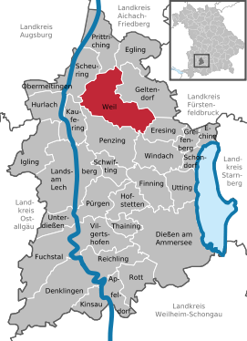
| Location of the community of Weil in the Landsberg am Lech district | ||
Weil is a municipality in the Upper Bavarian district of Landsberg am Lech .
geography
The community is located about nine kilometers northeast of Landsberg and is 30 and 50 kilometers away from Augsburg and Munich, respectively. It is traversed by the Lost Bach in a south-north direction , called Friedberger Ach in its lower course .
structure
The municipality consists of six districts , which correspond to the former municipalities, and has 14 officially named municipality parts :
- the Pfarrdorf Beuerbach with the Weiler Adelhausen and wastes Mangmühle , Wolfsmühle and Zellhof
- the parish village of Geretshausen with the wasteland Aumühle
- the parish village of Pestenacker
- the parish village of Petzenhausen
- the parish village of Schwabhausen near Landsberg with the hamlet of Machelberg
- the parish village of Weil with the hamlets of Missenhof and Neuweil
Neighboring communities
Neighboring communities are (clockwise from the north): Prittriching , Egling an der Paar , Geltendorf , Eresing , Windach , Penzing , Kaufering and Scheuring .
history
Until the church is planted
The place name Weil is of Roman origin and was originally Villa (manor).
Weil belonged to the Munich Rent Office and to the Landsberg Regional Court of the Electorate of Bavaria . The German Order ( Kommende Blumenthal ) had an open court mark here .
In the course of the administrative reforms in the Kingdom of Bavaria , the municipality of Weil was created with the municipal edict of 1818 .
Territorial reform
Today's community of Weil was created on January 1, 1972 in the course of the regional reform from the previously independent communities of Weil, Beuerbach, Geretshausen, Pestenacker, Petzenhausen and Schwabhausen near Landsberg.
Population development
Lived on the territory of the parish
- 1970: 2278 inhabitants
- 1987: 2608 inhabitants
- 1991: 2918 inhabitants
- 1995: 3141 inhabitants
- 2000: 3321 inhabitants
- 2005: 3626 inhabitants
- 2010: 3765 inhabitants
- 2015: 3775 inhabitants
- 2018: 3833 inhabitants
- 2019: 3854 inhabitants
Between 1988 and 2019 the municipality grew from 2,688 to 3,854 by 1,166 inhabitants or by 43.4%.
politics
Municipal council
After the municipal council election on March 16, 2014, the council was composed as follows:
| list | be right | percent | Seats |
| Village community Weil (DG Weil) | 9,867 | 34.98% | 6th |
| Free voter group Schwabhausen (FWG Schwabhausen) | 7,589 | 26.90% | 4th |
| Geretshausen village community (DG Geretshausen) | 3,437 | 12.18% | 2 |
| Village community Petzenhausen (DG Petzenhausen) | 2,958 | 10.49% | 2 |
| Free voters Pestenacker (FW Pestenacker) | 2,415 | 8.56% | 1 |
| Beuerbach village community (DG Beuerbach) | 1,944 | 6.89% | 1 |
coat of arms
The description of the coat of arms reads: In silver a black paw cross , covered with a silver heart shield , in it a red sheep scissors .
Coat of arms history
The black paw cross is the heraldic symbol of the Teutonic Knight Order. From the 13th century until the dissolution of the order in 1806, Weil belonged to the imperial rule of the Teutonic Order of Blumenthal near Aichach. The sheep shears in the heart shield are taken from the coat of arms of the former local lords, the Lords of Haldenberg. As early as 1260 the Haldenbergers handed over goods in Weil to the Teutonic Order; Konrad von Haldenberg himself entered the order in 1314.
Culture and sights
Weil became known nationwide through excavations of Stone Age wetland settlements in the valley of the Lost Brook near Pestenacker.
130 victims of Nazi tyranny were buried in three collective graves near the railway line in the cemetery of honor in the Schwabhausen district . The community of Weil speaks of 120 dead. Other places of 140 dead and more. A British or American reconnaissance aircraft discovered a parked ammunition train at this point on April 27, 1945. A train with up to 3,400 prisoners from the concentration camp Kaufering was then allegedly deliberately blocked by the escorts of the ammunition train . The low-flying aircraft that appeared shortly after fired at this train. Many of the 500 or so prisoners who fled were shot. The wounded Jews were taken to the hospital of the St. Ottilien Archabbey . Probably only 1,769 prisoners reached the Dachau destination station . Jewish inscriptions were placed on the memorial stones erected above the collective graves.
Architectural monuments
See: List of architectural monuments in Weil (Upper Bavaria)
Soil monuments
See: List of soil monuments in Weil (Upper Bavaria)
Web links
- Entry on the coat of arms of Weil (Upper Bavaria) in the database of the House of Bavarian History
- Schwabhausen - Pictures of the concentration camp cemetery in the district of Schwabhausen near Alemannia Judaica
- Weil (Upper Bavaria): Official statistics of the LfStat
Individual evidence
- ↑ "Data 2" sheet, Statistical Report A1200C 202041 Population of the municipalities, districts and administrative districts 1st quarter 2020 (population based on the 2011 census) ( help ).
- ^ Community Weil in the local database of the Bavarian State Library Online . Bavarian State Library, accessed on September 7, 2019.
- ^ Wilhelm Volkert (ed.): Handbook of Bavarian offices, communities and courts 1799–1980 . CH Beck, Munich 1983, ISBN 3-406-09669-7 , p. 507 .
- ^ Website of the community of Weil
- ↑ Memorial sites for the victims of National Socialism. A documentation, volume 1. Federal Agency for Civic Education, Bonn 1995, ISBN 3-89331-208-0 , p. 198
- ^ Community of Weil; History of the district of Schwabhausen
- ↑ Private page on the Ammersee- and Pfaffenwinkelbahn ( memento from February 11, 2010 in the Internet Archive ) in the Internet Archive
- ^ Concentration camp complex external command Kaufering


