Scheuring
| coat of arms | Germany map | |
|---|---|---|

|
Coordinates: 48 ° 10 ' N , 10 ° 54' E |
|
| Basic data | ||
| State : | Bavaria | |
| Administrative region : | Upper Bavaria | |
| County : | Landsberg am Lech | |
| Management Community : | Prittriching | |
| Height : | 564 m above sea level NHN | |
| Area : | 21.27 km 2 | |
| Residents: | 1945 (Dec. 31, 2019) | |
| Population density : | 91 inhabitants per km 2 | |
| Postal code : | 86937 | |
| Area code : | 08195 | |
| License plate : | LL | |
| Community key : | 09 1 81 138 | |
| LOCODE : | DE EU6 | |
| Community structure: | 4 parts of the community | |
| Address of the municipal administration: |
Kirchplatz 1 86937 Scheuring |
|
| Website : | ||
| Mayor : | Konrad Maisterl | |
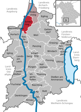
| Location of the community of Scheuring in the Landsberg am Lech district | ||
Scheuring is a municipality in the Upper Bavarian district of Landsberg am Lech and a member of the Prittriching administrative community .
geography
location
Scheuring is located in the Munich planning region . Only the Scheuring district exists . The Lech flows west of the village .
The lowest point of the community is at 536 m on the Lech, the highest at 615 m in the Westerholz.
Parish parts
The municipality has four officially named municipal parts (the type of settlement is given in brackets ):
- Haltberg ( wasteland )
- Lichtenberg ( good )
- Scheuring ( parish village )
- Customs house (wasteland)
history
Scheuring belonged to the Rentamt München and to the Landsberg Regional Court of the Electorate of Bavaria . The community of Scheuring is documented under Duke Heinrich IX. First mentioned in 1130 under the name Sciringen (Schyringen).
However, an earlier settlement can be assumed. The many grave mounds in the Westerholz southwest of the village indicate that the country was heavily populated in the Hallstatt period (750 to 450 BC). Finds from 1904 brought to light clay bowls, weapons and horse harness from this period. They are registered as a ground monument with the file number D-1-7831-0025 and are described as “grave mounds with burials from the Hallstatt period”.
Under Ludwig the Pious , the area around Scheuring came into the possession of the Guelphs . In 1169 ownership changed to the Hohenstaufen. In 1386 the area was owned by the Bavarian dukes Stephan and Johann , who in 1387 donated their tithe to the Schäftlarn monastery . From 1443 the monastery occupied the parish with its religious people, including some important abbots of the Schäftlarn monastery.
The districts of Haltberg and Lichtenberg, whose families named themselves after the districts and where a castle or an electoral palace formerly stood, can also have a varied history.
| year | 1840 | 1871 | 1900 | 1925 | 1939 | 1950 | 1961 | 1970 | 1987 | 1991 | 1995 |
| Residents | 670 | 567 | 658 | 717 | 703 | 1133 | 985 | 1115 | 1277 | 1428 | 1553 |
| year | 2001 | 2002 | 2003 | 2004 | 2005 | 2006 | 2007 | 2008 | 2009 | 2010 | 2011 | 2012 | 2013 | 2014 | 2015 | 2016 | 2017 |
| Residents | 1749 | 1739 | 1766 | 1814 | 1815 | 1814 | 1811 | 1825 | 1850 | 1835 | 1859 | 1872 | 1907 | 1904 | 1934 | 1951 | 1953 |
Between 1988 and 2018 the community grew from 1302 to 1971 by 669 inhabitants or by 51.4%.
politics
City council and mayor
| year | CSU | Village community | Free voters | total | voter turnout |
|---|---|---|---|---|---|
| 2014 | - | 7th | 5 | 12 | 58.7% |
| 2008 | 2 | 6th | 4th | 12 | 59.1% |
| 2002 | 2 | 6th | 4th | 12 | 78.3% |
Mayor is Konrad Maisterl. He became Manfred Menhard's successor in 2020.
Community finances
The municipal tax receipts amounted to 1931 T € in 2017, of which the trade tax receipts (net) amounted to 592 T €.
coat of arms
The description of the coat of arms reads: In the cloud section diagonally left divided by green and gold; a cross in a mixed up color at the top and bottom.
Architectural monuments
- Rectory , built in 1907
Soil monuments
See: List of ground monuments in Scheuring
Economy and Infrastructure
economy
In 2017, according to official statistics, there were 223 employees subject to social security contributions at the place of work. There were 813 employees subject to social security contributions at the place of residence. This means that the number of out-commuters was 590 higher than that of in-commuters. 25 residents were unemployed. In 2016 there were 29 agricultural holdings with an agricultural area of 875 ha, of which 768 ha were arable land and 106 ha were permanent grassland.
education
In 2018, the municipality had a day-care center with 90 places and 82 supervised children (eleven of them under three years of age) as well as an elementary school in which 163 pupils in eight classes were taught by twelve teachers.
Web links
- Entry on Scheuring's coat of arms in the database of the House of Bavarian History
Individual evidence
- ↑ "Data 2" sheet, Statistical Report A1200C 202041 Population of the municipalities, districts and administrative districts 1st quarter 2020 (population based on the 2011 census) ( help ).
- ^ Community Scheuring in the local database of the Bavarian State Library Online . Bavarian State Library, accessed on September 7, 2019.
- ↑ a b c d e Scheuring: Statistics communal 2018 (PDF; 1.7 MB), published in February 2019


