Hofstetten (Upper Bavaria)
| coat of arms | Germany map | |
|---|---|---|

|
Coordinates: 48 ° 1 ′ N , 10 ° 58 ′ E |
|
| Basic data | ||
| State : | Bavaria | |
| Administrative region : | Upper Bavaria | |
| County : | Landsberg am Lech | |
| Management Community : | Pürgen | |
| Height : | 674 m above sea level NHN | |
| Area : | 17.02 km 2 | |
| Residents: | 1886 (Dec. 31, 2019) | |
| Population density : | 111 inhabitants per km 2 | |
| Postal code : | 86928 | |
| Area code : | 08196 | |
| License plate : | LL | |
| Community key : | 09 1 81 124 | |
| Community structure: | 3 parts of the community | |
| Association administration address: | Weilheimer Str. 2 86932 Pürgen |
|
| Website : | ||
| Mayoress : | Ulrike Högenauer | |
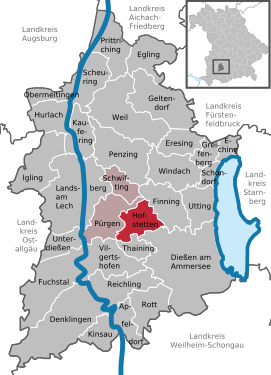
| Location of the municipality of Hofstetten in the Landsberg am Lech district | ||
Hofstetten is a municipality in the Upper Bavarian district of Landsberg am Lech . The place of the same name is both the capital and the seat of the municipal administration.
geography
The community lies in a pre-alpine moraine landscape between Lech and Ammersee in the so-called Lechrain area .
The lowest point in the community is at 625 m on the Windachspeicher , the highest at 710 m in Hohenbuch.
Parish parts
The municipality consists of two districts that correspond to the former municipalities and has three officially named municipality parts (the type of settlement is indicated in brackets ):
- Hagenheim ( Kirchdorf ) with Memming ( hamlet )
- Hofstetten ( parish village )
Grünsink is not an officially named part of the municipality and is part of Hagenheim.
history
Until the church is planted
Several barrows not far from the district road LL6 date back to the Hallstatt period.
Row grave finds at the Egelsee near Hagenheim from around 650, as well as the place name, suggest a settlement in the 7th century . This probably took place starting from today's hamlet of Memming.
Hofstetten is mentioned for the first time in 1083 in a deed of donation from Bishop Norbert zu Chur as Hovesteten . In this he bequeathed Hofstetten to Habach Monastery .
After the village was initially under the influence of the Guelphs and Staufers , it fell to the Wittelsbachers in 1231 , and in 1270 Hofstetten is listed in the basic directory of the Landsberg caste office.
The Wessobrunn monastery was important as a manorial estate in the entire municipality of Hofstetten until secularization in 1803 . The part of the municipality Hagenheim is mentioned as a Wessobrunn property as early as the High Middle Ages; from 1403 the church of Hagenheim was incorporated into the monastery (previously Habach Abbey). Hofstetten belonged to the Munich Rent Office and to the Landsberg Regional Court of the Electorate of Bavaria . In the course of the administrative reforms in the Kingdom of Bavaria , the municipal edict of 1818 created the municipalities of Hofstetten and Hagenheim.
Community merger
On January 1, 1972, Hagenheim and Hofstetten merged to form the new municipality of Hofstetten.
Population development
Between 1988 and 2019 the community grew from 1,306 to 1,886 by 580 inhabitants or 44.4%.
- 1961: 931 inhabitants, 317 of them in Hagenheim
- 1970: 999 inhabitants, 301 of them in Hagenheim
- 1987: 1245 inhabitants
- 1991: 1504 inhabitants
- 1995: 1589 inhabitants
- 2000: 1675 inhabitants
- 2005: 1759 inhabitants
- 2010: 1782 inhabitants
- 2015: 1838 inhabitants
- 2018: 1895 inhabitants
- 2019: 1886 inhabitants
politics
The community is a member of the administrative community of Pürgen .
mayor
Ulrike Högenauer has been the first mayor since 2020.
Municipal council
After the 2014 local elections, the local council has 12 members.
coat of arms
After the war, Hagenheim was one of the first municipalities in Bavaria to introduce a coat of arms. This coat of arms was slightly changed in the course of the amalgamation of the municipalities and is now used to represent the municipality of Hofstetten. The old original coat of arms still exists, but may only be used by Hagenheim associations and citizens.
The description of the coat of arms reads: Two silver spruce trees growing out of a silver hedge fence under a silver shield head in red with two diagonally crossed red keys.
Architectural monuments and ground monuments
Soil monuments
Economy and Infrastructure
Economy including agriculture and forestry
In 1998, according to official statistics, there were no employees at the place of work in the manufacturing industry 43 or in the trade and transport sector. In other economic areas, 18 people were employed at the place of work subject to social security contributions. There were a total of 214 employees at the place of residence subject to social insurance contributions. There were two companies in the manufacturing sector and three in the construction sector. In addition, in 1999 there were 40 agricultural holdings with an agriculturally used area of 657 ha, of which 544 ha were arable land and 112 ha were permanent grassland .
education
There are the following institutions (as of 2018):
- Kindergartens: 65 kindergarten places with 75 supervised children
Personalities
- Sebastian Fichtner (1894–1950), officer , last lieutenant general in World War II , lived in Hofstetten
Web links
Individual evidence
- ↑ "Data 2" sheet, Statistical Report A1200C 202041 Population of the municipalities, districts and administrative districts 1st quarter 2020 (population based on the 2011 census) ( help ).
- ^ Municipality of Hofstetten in the local database of the Bavarian State Library Online . Bavarian State Library, accessed on September 8, 2019.
- ^ Pankraz Fried , Peter Fassl: From Swabia and Altbayern . Thorbecke, 1991, ISBN 978-3-7995-7073-2 , pp. 127 .
- ^ Heide Weißhaar-Kiem: Landsberg am Lech district . Ed .: Landsberg am Lech district. 1st edition. EOS Verlag St. Ottilien, 2010, ISBN 978-3-8306-7437-5 , p. 215-217 .
- ^ Wilhelm Volkert (ed.): Handbook of Bavarian offices, communities and courts 1799–1980 . CH Beck, Munich 1983, ISBN 3-406-09669-7 , p. 507 .
- ↑ Mayoress. Municipality of Hofstetten (Upper Bavaria), accessed on August 19, 2020 .
- ↑ https://www.hofstetten-hagenheim.de/index.php/verwaltung/gemeinderat
- ^ Entry on the coat of arms of Hofstetten (Upper Bavaria) in the database of the House of Bavarian History


