
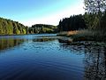
Vineyards on the Forggensee
| coat of arms | Germany map | |
|---|---|---|

|
Coordinates: 47 ° 37 ' N , 10 ° 43' E |
|
| Basic data | ||
| State : | Bavaria | |
| Administrative region : | Swabia | |
| County : | Ostallgäu | |
| Management Community : | Horseheads | |
| Height : | 814 m above sea level NHN | |
| Area : | 13.17 km 2 | |
| Residents: | 1324 (Dec. 31, 2019) | |
| Population density : | 101 inhabitants per km 2 | |
| Postal code : | 87669 | |
| Area code : | 08362 | |
| License plate : | OAL, FÜS, MOD | |
| Community key : | 09 7 77 163 | |
| Community structure: | 6 parts of the community | |
| Address of the municipal administration: |
Lindenweg 4 87669 Rieden am Forggensee |
|
| Website : | ||
| Mayor : | Andreas Haug (Free Village Community) | |
| Location of the municipality of Rieden am Forggensee in the Ostallgäu district | ||
  |
||


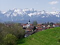
Rieden am Forggensee is a municipality in the Swabian district of Ostallgäu and a member of the Roßhaupten administrative community .
geography
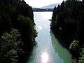
Rieden am Forggensee is located on a reservoir of the Lech, the Forggensee , in the Allgäu region and borders the lake with 8 kilometers of shore.
The municipality has 6 officially named municipality parts :
- Dietringen ( village )
- Dürracker ( wasteland )
- Osterreinen (village)
- Rieden am Forggensee ( parish village )
- Sankt Urban (wasteland)
- Schönenried (wasteland)
history
Until the church is planted
Rieden am Forggensee belonged to the monastery Augsburg . As the seat of an episcopal bailiff, the place developed into a village. In 1850, the Riedener church became a parish church instead of the St. Urban church outside. With the Reichsdeputationshauptschluss of 1803 , the place came to Bavaria. In the course of the administrative reforms in the Kingdom of Bavaria , today's municipality was created with the municipal edict of 1818 .
20th century
At the beginning of the 1950s, parts of the municipality were lost due to the construction of the Forggen lake. On October 18, 1972, the municipality of Rieden was officially renamed "Rieden am Forggensee".
On May 1, 1978, the municipality of Rieden am Forggensee was dissolved . Its main part with about 800 inhabitants at that time came to the community of Roßhaupten. Smaller areas with around 25 inhabitants at that time were incorporated into the city of Füssen.
On November 5, 1980, the municipality was re-established by a judgment of the Bavarian Administrative Court . Roßhaupten completely ceded the parts of the territory it had taken over. The parts of the area taken over by the city of Füssen remained there.
Population development
| Population development | ||||||||||||||
|---|---|---|---|---|---|---|---|---|---|---|---|---|---|---|
| year | 1840 | 1900 | 1939 | 1950 | 1961 | 1970 | 1987 | 1991 | 1995 | 2000 | 2005 | 2010 | 2015 | |
| Residents | 474 | 398 | 445 | 785 | 672 | 817 | 991 | 1094 | 1178 | 1161 | 1214 | 1247 | 1269 | |
Rieden am Forggensee grew by 225 inhabitants or approx. 22% from 1988 to 2008. Between 1988 and 2018 the community grew from 1,031 to 1,336 by 305 inhabitants or 29.6%.
politics
mayor
On March 15, 2020, Andreas Haug (Free Village Community Rieden) was elected mayor with 73.68% of the votes. On May 1, 2020, he succeeded Maximilian Streif (* 1945; CSU / Free Voting Association), who had been the head of the community since July 24, 1995.
Municipal council
For the election on March 15, 2020 , only the nomination of the Free Village Community of Rieden with 24 applicants was available. The twelve applicants from this group of voters with the highest number of votes form the municipal council for May 2020 to April 2026 together with the mayor. The turnout was 71.5%.
Community finances
In 2010 the municipal tax revenue amounted to 823,000 euros, of which 117,000 euros were trade tax revenue (net).
coat of arms
The description of the municipal coat of arms, adopted in 1983, reads: "In a wavy cut divided by red and silver, a red Reuthaue and a red ax crossed at the bottom, a heraldic lily in confused colors placed on the dividing line, the middle leaf of which is designed as a vine leaf at the top."
Architectural monuments
Attractions
- The Rieden am Forggensee doll museum has a collection of more than 600 dolls and exhibits.
- There is a DAV climbing center on the northern edge of the village.
- The Forggensee offers a wide range of leisure activities in the districts of Dietringen and Osterreinen.
- The idyllic Faulensee and the Hopferwald are ideal for long hikes.

Farmhouse on the northern outskirts
Lazy Lake

Autumn at the Forggensee

Winter at the Forggensee
Vineyards on the Forggensee from the north

St. Urban from the north
Tiefenthal


Economy and Infrastructure
economy
According to official statistics, there were 447 employees at the place of work in the manufacturing sector and 51 in trade and transport. In other economic sectors 36 people were employed at the place of work subject to social security contributions. There were a total of 418 employees at the place of residence subject to social security contributions. There were three companies in the manufacturing sector and two in the construction sector. In addition, there were 25 agricultural holdings with an agricultural area of at least two hectares, which farmed an area of 573 hectares. In 2013 the municipality counted around 65,000 overnight stays with guests, and the trend is rising.
education
In 2010 the kindergarten “St. Leonhard ”with 50 kindergarten places, in which 36 children were looked after by four teachers.
Personalities
- Trixini (1933–2015), (actually Hansjörg Kindler), theologian, puppeteer and magician; lived and worked in Rieden am Forggensee
Web links
- Entry on the coat of arms of Rieden am Forggensee in the database of the House of Bavarian History
- Rieden am Forggensee: Official statistics of the LfStat (PDF; 1.05 MB)
Individual evidence
- ↑ "Data 2" sheet, Statistical Report A1200C 202041 Population of the municipalities, districts and administrative districts 1st quarter 2020 (population based on the 2011 census) ( help ).
- ^ Community Rieden am Forggensee in the local database of the Bavarian State Library Online . Bayerische Staatsbibliothek, accessed on August 17, 2019.
- ↑ a b c d e Federal Statistical Office (Hrsg.): Historical municipality register for the Federal Republic of Germany. Name, border and key number changes in municipalities, counties and administrative districts from May 27, 1970 to December 31, 1982 . W. Kohlhammer, Stuttgart / Mainz 1983, ISBN 3-17-003263-1 , p. 779 .

Aitrang | Baisweil | Bidingen | Biessenhofen | Buchloe | Eggenthal | Eisenberg | Friesenried | Feet | Germaringen | Görisried | Günzach | Halbch | Hopferau | Irsee | Jengen | Kaltental | Kraftisried | Lamerdingen | Lechbruck am See | Lengenwang | Marktoberdorf | Mauerstetten | Nesselwang | Obergünzburg | Oberostendorf | Osterzell | Pforzen | Pfronten | Rettenbach am Auerberg | Vineyards | Vineyards on the Forggensee | Ronsberg | Roßhaupten | Backwood | Ruderatshofen | Schwangau | Seeg | Stötten am Auerberg | Stöttwang | Unterthingau | Untrasried | Waal | Forest | Westendorf