
Ronsberg
| coat of arms | Germany map | |
|---|---|---|

|
Coordinates: 47 ° 54 ' N , 10 ° 25' E |
|
| Basic data | ||
| State : | Bavaria | |
| Administrative region : | Swabia | |
| County : | Ostallgäu | |
| Height : | 701 m above sea level NHN | |
| Area : | 16.53 km 2 | |
| Residents: | 1734 (Dec. 31, 2019) | |
| Population density : | 105 inhabitants per km 2 | |
| Postcodes : | 87671, 87724 | |
| Area code : | 08306 | |
| License plate : | OAL, FÜS, MOD | |
| Community key : | 09 7 77 165 | |
| LOCODE : | DE RBE | |
| Market structure: | 17 parts of the community | |
Market administration address : |
Schulweg 3 87671 Ronsberg |
|
| Website : | ||
| Mayor : | Michael Sturm ( Citizen List Ronsberg ) | |
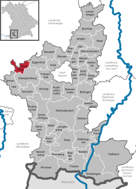
| Location of the Ronsberg market in the Ostallgäu district | ||
  |
||

Ronsberg is a market in the Swabian district of Ostallgäu .


geography
location
Ronsberg is in the Allgäu region and is traversed by the Eastern Günz . The lowest point in the municipality is at 685 m above sea level on the border with the Unterallgäu district on the eastern Günz, the highest point at 841 m above sea level in the Bremberger Forest on the OAL 5 between Obergünzburg and Ollarzried .
Community structure
The municipality has 17 officially named municipal parts (the type of settlement is given in brackets ):
|
|
|
There is only the Ronsberg district .
history
Until the 19th century
The Lords of Ursin built their new ancestral castle on the Ronsberg around 1130 after they moved. Before that, they had been based in Irsee since around 980 . The Ursin-Ronsbergers , named after their new headquarters , rose to the margrave status in 1182 . In 1212 they became extinct in the male line . Ronsberg, which was raised to market in 1546, had been the seat of a lordship since the 13th century. This, all under Austrian sovereignty, was divided between the Principality of Kempten and the Ottobeuren Abbey . The place Ronsberg itself was in the Kemptischen part of the rule. Since the Reichsdeputationshauptschluss of 1803 the place belongs to Bavaria. In the course of the administrative reforms in the Kingdom of Bavaria , today's municipality was created with the municipal edict of 1818 . The construction of the first parish church in Ronsberg took place from 1845 to 1847.
Incorporations
On January 1, 1972, as part of the municipal reform, the hamlet of Bihls was incorporated from the previously independent municipality of Willofs. The remaining area of the dissolved municipality was reclassified to Obergünzburg .
Population development
Between 1988 and 2008 the population of Ronsberg increased only minimally by 0.6%. Between 1988 and 2018, the municipality grew from 1626 to 1709 by 83 inhabitants or 5.1%.
- 1961: 1482 inhabitants
- 1970: 1665 inhabitants
- 1987: 1623 inhabitants
- 1991: 1672 inhabitants
- 1995: 1713 inhabitants
- 2000: 1713 inhabitants
- 2005: 1658 inhabitants
- 2010: 1629 inhabitants
- 2015: 1708 inhabitants
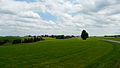
photos

Günzmäander

Mindelmühle from the north
Oberweiler from the northwest

Ronsberg from the west


politics
mayor
On March 15, 2020, Michael Sturm (Ronsberg's list of citizens) was elected mayor with 95.8% of the vote. His predecessors were Gerhard Kraus (Free Voters) from May 2002 to April 2020 and Peter Wertk ( CSU ) until April 2002 .
Municipal council
For the election on March 15, 2020 , only the nomination of the Ronsberg citizens' list with 14 applicants was available. The twelve applicants from this group of voters with the highest number of votes form the municipal council for May 2020 to April 2026 together with the mayor. The turnout was 53.9%.
coat of arms
Blazon : In red, a golden lion holding a banner divided diagonally by blue and silver on an equally diagonally banded rod in its front paws.
Architectural monuments
Economy and Infrastructure
Economy including agriculture and forestry
In 1998, according to official statistics, there were 1,145 people in the manufacturing sector and no employees in the area of trade and transport who were subject to social security contributions at the place of work. In other economic areas, 47 people were employed at the place of work subject to social security contributions. There were a total of 619 employees at the place of residence subject to social security contributions. There was one in the manufacturing sector and three in the construction sector. In addition, in 1999 there were 50 farms with an agricultural area of 1069 hectares, of which 1022 hectares were permanent green space. An important local company is the Finnish packaging manufacturer Huhtamaki , Ronsberg branch with over 1000 jobs.
education
In 2008 the following institutions existed:
- Kindergartens: 85 kindergarten places with 75 children
- Elementary schools: one with 11 teachers and 153 students
Personalities
National soccer player Mario Götze (* 1992), spent the first six years of his life here before his parents moved to Dortmund .
Barbara Lochbihler , member of the European Parliament since 2009, grew up in the town.
Web links
- Entry on the Ronsberg coat of arms in the database of the House of Bavarian History
- Homepage Ronsberg market
- Homepage of Dingisweiler
- Ronsberg: Official statistics of the LfStat (PDF; 1.05 MB)
Individual evidence
- ↑ "Data 2" sheet, Statistical Report A1200C 202041 Population of the municipalities, districts and administrative districts 1st quarter 2020 (population based on the 2011 census) ( help ).
- ^ Community Ronsberg in the local database of the Bayerische Landesbibliothek Online . Bayerische Staatsbibliothek, accessed on August 17, 2019.
- ↑ Cf. Marcus Simm: The king's city at Buron. Kaufbeuren - An urban archaeological study on genesis, early development and topography. Thalhofen, 2012. 173.
- ^ Wilhelm Volkert (ed.): Handbook of Bavarian offices, communities and courts 1799–1980 . CH Beck, Munich 1983, ISBN 3-406-09669-7 , p. 519 .

Aitrang | Baisweil | Bidingen | Biessenhofen | Buchloe | Eggenthal | Eisenberg | Friesenried | Feet | Germaringen | Görisried | Günzach | Halbch | Hopferau | Irsee | Jengen | Kaltental | Kraftisried | Lamerdingen | Lechbruck am See | Lengenwang | Marktoberdorf | Mauerstetten | Nesselwang | Obergünzburg | Oberostendorf | Osterzell | Pforzen | Pfronten | Rettenbach am Auerberg | Vineyards | Vineyards on the Forggensee | Ronsberg | Roßhaupten | Backwood | Ruderatshofen | Schwangau | Seeg | Stötten am Auerberg | Stöttwang | Unterthingau | Untrasried | Waal | Forest | Westendorf