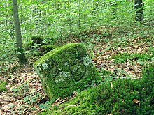
Forest Bayerdießen
The Bayerdießen forest is a forestry and ecologically significant forest area in the Bavarian Alpine foothills between Dießen am Ammersee and Wessobrunn .
geography
The contiguous forest area around the Bayerdießen forest extends over 3300 hectares on a ridge southwest of the Ammersee at an altitude of 570 to 740 m above sea level. NHN . The market in Dießen am Ammersee and the community of Rott in the Landsberg am Lech district , as well as the communities of Wessobrunn and Raisting in the Weilheim-Schongau district, have a share in the forest area .
One part of the area is the Bayerdießen district , which only comprises 1,418 hectares of state forest .
A section of the König-Ludwig-Weg runs through the forest .
Natural space
The forest area is only cut up by the state road 2055 , the only settlement is the desert Abtsried .
In the forest there is a landscape protection area to preserve the Beermoos mountain pine population near Abtsried. There is also the nature reserve Erlwiesfilz, Bremstauden, Am Eschenbächel.
Numerous rivers can be found in the Bayerdießen forest, the most important being the Rott and its tributary, the Hintere Krebsbach.
history
From pre- and early historic time a location in the corridor Viehhaus section mounting and several originate grave mounds north of Abtsried.
In Roman times a Roman road ran from Bregenz to Salzburg through the forest area. The body of the road can still be seen in some places today.
To the north of Stillern is the castle stables of the former Menburg from the 11th century.
The forest was first mentioned in a document in 1391 as part of the ruling court of Rauhenlechsberg . This is probably the forest of an old royal palace that came to the Counts of Dießen and from these fell to the Wittelsbachers in 1248 .
Finally, in 1599, the forest court was detached from the Rauhenlechsberg nursing court and merged with the Diessen Maritime Court.
The border between the Dießen monastery and the Wessobrunn monastery ran through the Bayerdießen forest since the Middle Ages . A number of boundary stones from 1680 still bear witness to this borderline today. Today it forms the border between the Landsberg am Lech and Weilheim-Schongau districts.
In the course of secularization in 1802/03, the forest area fell to Kurbayern , and a forestry office was set up in Dießen on November 22, 1803 to manage the 5496 hectare forest . The former market, sea and forest judge was the first royal district forester. The Forest Service was established in 2006 as part of the Forestry Reform dissolved.
swell
- ↑ Reorganization of the zoning plan - PDF. Retrieved January 17, 2019 .
- ↑ Landscape protection areas - organizational overview. Retrieved January 17, 2019 .
- ↑ Order on the nature reserve "Erlwiesfilz", Bremstauden "," Am Eschenbächel "(3 km north of Wessobrunn) in the Landsberg district. Accessed on January 17, 2019 .
- ↑ Roman roads in the Ammer Moss - local historian Dießen. Retrieved January 17, 2019 (German).
- ↑ Dr. Walter Töpner: Ammersee-Lechrain . Ed .: Bauer Verlag. S. 22 .
- ↑ P. Fried: Excursus on the Dießen Forest . 1969, p. 51-85 .
- ^ Map for those interested in history - local researcher Dießen. Retrieved January 17, 2019 (German).
- ^ Josef Anton Hugo, Eduard Gabelsberger: Chronicle of the market and the parish of Diessen . Dießen am Ammersee 1901.
- ↑ Ammersee - Lechsberg>. Retrieved January 29, 2019 .
Coordinates: 47 ° 54 ′ 20 ″ N , 11 ° 3 ′ 1 ″ E


