Administrative community Igling
| coat of arms | Germany map | |
|---|---|---|

|
Coordinates: 48 ° 4 ′ N , 10 ° 49 ′ E |
|
| Basic data | ||
| State : | Bavaria | |
| Administrative region : | Upper Bavaria | |
| County : | Landsberg am Lech | |
| Area : | 53.45 km 2 | |
| Residents: | 6185 (Dec. 31, 2019) | |
| Population density : | 116 inhabitants per km 2 | |
| License plate : | LL | |
| Association key : | 09 1 81 5139 | |
| Association structure: | 3 municipalities | |
| Association administration address : |
Unteriglinger Str. 37 86859 Igling |
|
| Website : | ||
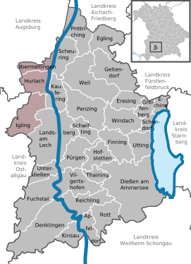
| Location of the administrative community Igling in the Landsberg am Lech district | ||
The administrative community Igling in the Upper Bavarian district of Landsberg am Lech was created on May 1, 1978 by statutory order of the government of Upper Bavaria.
Members are the parishes
- Hurlach , 1942 inhabitants, 17.18 km²
- Igling , 2488 inhabitants, 26.34 km²
- Obermeitingen , 1755 inhabitants, 9.93 km²
The administrative association is based in Igling.
Members of the administrative community are also the water supply association for the Erpftinger Group and the Igling-Hurlach school association.
Individual evidence
- ↑ "Data 2" sheet, Statistical Report A1200C 202041 Population of the municipalities, districts and administrative districts 1st quarter 2020 (population based on the 2011 census) ( help ).


