List of geotopes in the Landsberg am Lech district
This list contains the geotopes of the Upper Bavarian district of Landsberg am Lech in Bavaria . The list contains the official names and numbers of the Bavarian State Office for the Environment (LfU) as well as their geographical location. This list may not be complete. Around 3,400 geotopes (as of March 2020) are recorded in the Bavarian geotope register. The LfU does not consider some geotopes suitable for publication on the Internet. For example, some objects are not safely accessible or may only be entered to a limited extent for other reasons.
| Surname | image | Geotope ID | Municipality / location | Geological unit of space | description | Area m² / extension m | geology | Digestion type | value | Protection status | comment |
|---|---|---|---|---|---|---|---|---|---|---|---|
| Tufa wall in Dießen | 181A002 |
Dießen am Ammersee position |
Isar-Loisach young moraine region | The tufa wall is partially grown and serves as the house foundation. The tufa was mined earlier. | 180 30 × 6 |
Type: Rock type, sinter formation Type: Tufa limestone |
Quarry | significant | no protected area | ||
| Interglacial calcareous sintering E von Hurlach | 181A004 |
Hurlach position |
Iller-Lech region | In the profile, diverse spring limes are formed with a species-poor but individual mollusc fauna. They differ from the frequent postglacial calcareous sinter formations in the Alpine foothills in their interglacial age. They were exposed by the recent deep erosion on the Lech slope. | 200 200 × 1 |
Type: Sinter formation, Animal fossils, Vegetable fossils Type: Tufa, gravel |
Impact slope / river bed / stream profile | especially valuable | Landscape protection area, FFH area | ||
| Lechprallhang NE from Mundraching | 181A005 |
Vilgertshofen position |
Iller-Lech region | On the impressive Lech impact slope, large landslides occur again and again, in which the Upper Freshwater Molasse and the overlying gravel are exposed. | 10000 200 × 50 |
Type: Sequence of layers, impact slope Type: Marlstone, gravel |
Impact slope / river bed / stream profile | significant | Landscape protection area, FFH area, bird sanctuary | ||
| Toteiskessel NW of Memming |
 |
181R001 |
Hofstetten position |
Isar-Loisach young moraine region | The large trough-like depression has partly steep, partly flat edges up to about 8 m high. Smaller peaks and valleys divide the tub. In the deepest is a pond that may have been artificially deepened. | 5000 100 × 50 |
Type: Dead ice hole, end (wall) moraine Type: moraine |
no information | significant | no protected area | |
| Dead ice kettle Sandbergweiher SW of Dießen |
 |
181R002 |
Dießen am Ammersee position |
Isar-Loisach young moraine region | The dead ice kettle is located in the wall moraine of the inner terminal moraine. The edge of the pond was artificially raised. | 4000 80 × 50 |
Type: Dead ice hole, end (wall) moraine Type: moraine |
no information | significant | Part of the landscape, FFH area | |
| Erratic block in Thaining |
 |
181R003 |
Thaining position |
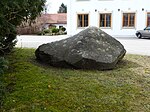
Isar-Loisach young moraine region | The boulder made of coarse-grained (molasse) sandstone lies on the forecourt of the church. It shows typical fracture structures as well as scratches and cuts. | 3 2 × 2 |
Type: Boulder Type: Sandstone |
block | inferior | no protected area | |
| Toteisloch SE from Ramsach |
 |
181R004 |
Penzing position |
Isar-Loisach young moraine region | The kettle is located between the Ramsacher and Schöffeldinger terminal moraine. It can only be made out indistinctly because it is flat and silted up. | 30000 200 × 150 |
Type: Dead Ice Hole Type: Moraine |
no information | significant | Natural monument | |
| Moränensee NW from Unterfinning |
 |
181R006 |
Finning position |
Isar-Loisach young moraine region | The silted up lake basin is surrounded by steep edges. According to Schäfer, it is a moraine lake. | 37500 250 × 150 |
Type: Terminal moraine lake Type: Moraine |
no information | significant | Natural monument | |
| Toteisloch Egelsee E from Hagenheim |
 |
181R007 |
Hofstetten position |
Isar-Loisach young moraine region | In wet years the groundwater is available in the large, tub-shaped dead ice hole (it is then used as a bathing pond). The edges are up to 8 m high, partly steep, partly flat. From the south a wide came protrudes like a finger into the dead ice hole. | 60000 300 × 200 |
Type: Dead Ice Hole Type: Moraine |
no information | significant | Natural monument | |
| Terminal moraine Vogelberg N from Geltendorf | 181R008 |
Geltendorf position |
Isar-Loisach young moraine region | The outer Würm terminal moraine is only preserved in remnants, but there in its typical shape with a flat northern and steeper southern slope. | 80000 400 × 200 |
Type: End (wall) moraine Type: Moraine |
no information | significant | Natural monument | ||
| Lechufer E from Kinsau |

|
181R009 |
Apple village position |
Isar-Loisach young moraine region | Much of the slope of the Lech is difficult to access. Various Quaternary gravel and moraines are exposed, especially on slippery slopes. The lower part of the slope is formed by marls of the Upper Freshwater Molasse, which act as water reservoirs. Numerous springs emerge above the marl, below which tufa limestone has partially deposited. | 50000 1000 × 50 |
Type: Impact slope, layer sequence Type: moraine, marlstone |
Impact slope / river bed / stream profile | significant | Nature reserve, natural monument, landscape protection area | |
| Tuff wall in the 'Teufelsküche' S of Landesberg | 181R010 |
Landsberg am Lech position |
Iller-Lech region | Spring outlets at the boundary between the gravel and the Upper Freshwater Molasse led to the deposition of a tufa wall up to 5 m thick. Smaller landslides are fixed by tufa limestone. In the area there are other smaller tufa walls and individual outcrops on landslides. | 250 25 × 10 |
Type: Sinter formation, layer source Type: Tufa, marlstone |
no information | significant | Landscape reserve, bird sanctuary | ||
| Landslide on the Lechufer SW of Reichling | 181R011 |
Reichling position |
Iller-Lech region | The landslide is around 100 m wide and 30 m high and offers a magnificent outcrop that is hardly accessible from close up. The landslide is related to the impact slope of the Lechschleife. In the neighborhood there are still numerous older, inactive landslides and outcrops of Upper Freshwater Molasse. | 20000 200 × 100 |
Type: landslide, layer sequence Type: moraine, gravel |
Impact slope / river bed / stream profile | precious | Landscape protection area, FFH area, bird sanctuary | ||
| Lech-Prallhang near Kaufering | 181R012 |
Kaufering position |
Iller-Lech region | The upper freshwater molasse / high terrace gravel border is open on the rebound slope. Depending on the water level, the outcrop is difficult to access. | 5000 250 × 20 |
Type: Impact slope, type of layers : gravel, marlstone |
Impact slope / river bed / stream profile | significant | Landscape protection area, FFH area | ||
| Upper Riedberg W from Stoffersberg | 181R013 |
Igling position |
Iller-Lech region | The stratigraphic position of the Stoffersberg is not yet certain (Danube time or Biber time). On the hilltop you can find overgrown mines. Important information from classical Pleistocene research. | 60000 600 × 100 |
Type: Inselberg / Zeugenberg, type of layer sequence : gravel |
no information | precious | no protected area | ||
| Terrace stairs S from Apfeldorf |
 |
181R014 |
Apple village position |
Iller-Lech region | To the south of Apfeldorf, one can marvel at an exemplary terrace staircase on the Lech. Several Worm Ice Age and Holocene terraces of different heights and widths follow one another. The worm-age moraine walls protrude from the uppermost terrace level. | 800000 1000 × 800 |
Type: terrace, impact slope, end (wall) moraine Type: gravel, moraine |
no information | precious | no protected area | |
| Steinerne gutter S from Kaufering |
 |
181R015 |
Kaufering position |
Iller-Lech region | Two small springs emerge on the terrace to the south and west of St. Leonhard, below which tufa limestone is deposited. Small stone gutters have formed. It is interesting that some of the gutters continue on the level below the terrace level, parallel to its course. | 100 100 × 1 |
Type: Stone gutter Type: Tufa limestone |
no information | significant | Natural monument, landscape protection area, FFH area |
See also
- List of nature reserves in the Landsberg am Lech district
- List of landscape protection areas in the Landsberg am Lech district
- List of FFH areas in the Landsberg am Lech district
- List of natural monuments in the Landsberg am Lech district
Individual evidence
- ↑ Data source: Bavarian State Office for the Environment, www.lfu.bayern.de, Geotoprecherche (accessed on September 16, 2017)
Web links
Commons : Geotopes in the Landsberg am Lech district - collection of images, videos and audio files