
Schwabsoien
| coat of arms | Germany map | |
|---|---|---|

|
Coordinates: 47 ° 50 ' N , 10 ° 50' E |
|
| Basic data | ||
| State : | Bavaria | |
| Administrative region : | Upper Bavaria | |
| County : | Weilheim-Schongau | |
| Management Community : | Altenstadt (Upper Bavaria) | |
| Height : | 746 m above sea level NHN | |
| Area : | 17.03 km 2 | |
| Residents: | 1394 (Dec. 31, 2019) | |
| Population density : | 82 inhabitants per km 2 | |
| Postal code : | 86987 | |
| Area code : | 08868 | |
| License plate : | WM, SOG | |
| Community key : | 09 1 90 151 | |
| LOCODE : | DE SS9 | |
| Community structure: | 3 parts of the community | |
| Association administration address: | Marienplatz 2 86972 Altenstadt |
|
| Website : | ||
| Mayor : | Manfred Schmid ( village community ) | |
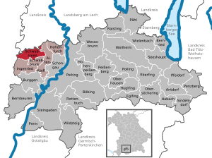
| Location of the municipality of Schwabsoien in the Weilheim-Schongau district | ||
  |
||


Schwabsoien is a municipality in the Upper Bavarian district of Weilheim-Schongau and a member of the Altenstadt administrative community .
geography
Schwabsoien is located in the Oberland region on the northwestern edge of the Pfaffenwinkel at an altitude of 730 to 860 m above sea level. NHN.
The headwaters of the Schönach , a tributary of the Lech, are located in the municipality .
The municipality has three officially named municipal parts (the type of settlement is indicated in brackets ):
- Dietlried ( wasteland )
- Sachsenried ( parish village )
- Schwabsoien (parish village)
There are the districts of Sachsenried and Schwabsoien.
history
Until the church is planted
Schwabsoien is first mentioned in a document in 1249. The name "-soien" ( Sewen, Soya, Soyen, Soien ) refers to lakes that no longer exist. A lake mentioned in 1589 has silted up. From 1423 there was a customs post; the customs were taken in favor of the city of Schongau after Augsburg merchants tried to bypass the customs for their wagons in Schongau by a detour via Schwabsoien. Until 1785 the place belonged to the bishopric Augsburg . It was exchanged for the Munich Rent Office and the Schongau Regional Court of the Electorate of Bavaria . In 1818 today's community was established.
19th and 20th centuries
In 1823 a fire destroyed most of the town. From 1866 to 1925 Schwabsoien was a post office on the Kaufbeuren – Schongau route (“Zur Post” inn).
Incorporations
On May 1, 1978, the previously independent municipality of Sachsenried was incorporated as part of the municipal reform.
The Altenstadt administrative community was founded in the same year.
Population development
- 1961: 1068 inhabitants
- 1970: 1110 inhabitants
- 1987: 1072 inhabitants
- 1991: 1144 inhabitants
- 1995: 1243 inhabitants
- 2000: 1268 inhabitants
- 2005: 1327 inhabitants
- 2010: 1297 inhabitants
- 2015: 1337 inhabitants
- 2020: 1453 inhabitants
The population figures refer to today's municipality.
Schwabsoien grew from 1988 to 2008 by 217 inhabitants or approx. 20%. Between 1988 and 2018 the municipality grew from 1,073 to 1,393 by 320 inhabitants or 29.8%.
politics
mayor
Manfred Schmid (village community) has been the first mayor since 2020.
tax income
In 2013, the municipal tax revenue was € 1,093,000, of which the trade tax revenue ( net ) was € 345,000.
Auerbergland
Schwabsoien is a member municipality of the inter-municipal alliance Auerbergland, which crosses the borders of the administrative districts of Swabia and Upper Bavaria .
Culture and sights
Architectural monuments
- Catholic parish church St. Martin in Sachsenried
Soil monuments
See: List of ground monuments in Schwabsoien
Museums
Economy and Infrastructure
Economy including agriculture and forestry
In 2013, 524 people were subject to social security contributions at their place of residence. 199 people were subject to social security contributions at the Schwabsoien workplace, 25 more than five years earlier. The number of out-commuters was 325 higher than that of in-commuters. In 2010 34 farms were registered. The agricultural area is 996 ha.
education
There are the following institutions (as of 2018):
- Kindergarten with 50 kindergarten places
- Elementary school with four classes and 82 students
Web links
- Entry on the coat of arms of Schwabsoien in the database of the House of Bavarian History
- Schwabsoien: Official statistics of the LfStat (PDF; 1.24 MB)
Individual evidence
- ↑ "Data 2" sheet, Statistical Report A1200C 202041 Population of the municipalities, districts and administrative districts 1st quarter 2020 (population based on the 2011 census) ( help ).
- ^ Community Schwabsoien in the local database of the Bayerische Landesbibliothek Online . Bayerische Staatsbibliothek, accessed on September 4, 2019.
- ^ Federal Statistical Office (ed.): Historical municipality directory for the Federal Republic of Germany. Name, border and key number changes in municipalities, counties and administrative districts from May 27, 1970 to December 31, 1982 . W. Kohlhammer, Stuttgart / Mainz 1983, ISBN 3-17-003263-1 , p. 596 .

Cities: Penzberg | Schongau | Weilheim in Upper Bavaria
Markets: Peißenberg | Peiting
Other municipalities: Altenstadt (Upper Bavaria) | Antdorf | Bernbeuren | Bernried am Starnberger See | Böbing | Burggen | Eberfing | Eglfing | Habach | Hohenfurch | Hohenpeissenberg | Huglfing | Iffeldorf | Ingenried | Oberhausen (near Peißenberg) | Obersöchering | Pähl | Polling (near Weilheim) | Prem | Raisting | Rottenbuch | Schwabbruck | Schwabsoien | Seeshaupt | Sindelsdorf | Steingaden | Wessobrunn | Wielenbach | Wildsteig