Wurmansau
|
Wurmansau
Saulgrub parish
Coordinates: 47 ° 38 ′ 42 " N , 11 ° 1 ′ 43" E
|
|
|---|---|
| Height : | 869 m above sea level NN |
| Residents : | 129 (1987) |
| Postal code : | 82442 |
| Area code : | 08845 |
|
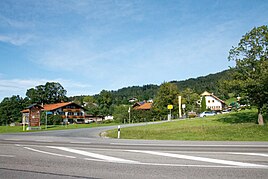
The place from the B 23
|
|
Wurmansau is a part of the municipality of Saulgrub in the Upper Bavarian district of Garmisch-Partenkirchen .
location
The village is located in the southeast of the municipality, just under 2.5 km south of Saulgrub and about one kilometer southeast of the Saulgrub district of Altenau on the western slope of the Hörnle at an altitude of 869 m above sea level. NHN . The Grüngraben, a source stream of the Ammer, runs to the south . Another tributary of the Ammer, whose numerous springs are located in the valleys to the east, crosses the place. Bundesstraße 23 passes in the west .
Townscape
The village extends along the Old Roman Road, which runs in a north-south direction. The Chapel of St. Joseph is located at a crossroads where a stream also crosses the street . One of the oldest buildings in Wurmansau is the Ammertalerhof, a historic inn on a bend in the old Roman road.
Architectural monuments
A grain box is entered on the list of monuments next to the St. Josef chapel .
Web links
- Wurmansau in the location database of the Bayerische Landesbibliothek Online . Bavarian State Library
- Wurmansau. In: Website of the Saulgrub community.
- Wurmansau in the historical directory of the association for computer genealogy
Individual evidence
- ^ Wurmansau in the historical directory of the Association for Computer Genealogy
- ↑ Wurmansau. In: BayernAtlas of the Bavarian State Government ( information ). Retrieved October 15, 2019 .
