
Rottachberg
| Rottachberg | ||
|---|---|---|
 On the Rottachberg, way from the Gebhardshöhe to the Falkenstein |
||
| height | 1115 m above sea level NHN | |
| location | Bavaria , Germany | |
| Mountains | Pre-Alps east of the Iller , Allgäu Alps | |
| Dominance | 3 km → Grünten | |
| Notch height | 275 m ↓ at Kalchenbach | |
| Coordinates | 47 ° 35 '27 " N , 10 ° 17' 34" E | |
|
||
| rock | Molasse ( Nagelfluh ) | |

The Rottachberg is a 1115 m high mountain in the Allgäu Alps . The mountain takes its name from the Rottach flowing past it to the north , its summit is called Falkenstein or Auf dem Falken. The relatively low, eight kilometer long, wooded Rottachberg is slightly offset from the Grünten. The municipality of Rettenberg is located between these two mountains . At the northern end of the mountain are the ruins of the high medieval Rettenberg Castle . At the southern end on Gebhardshöhe is a lookout point with a pavilion.
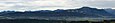
Rottachberg and Grünten from the Stoffelberg

Rottachberg vom Grünten

Falkenstein am Rottachberg
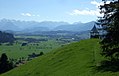
Pavilion on the Gebhardshöhe


Ascent
The Rottachberg is well developed with hiking trails. An approximately two and a half hour round leads from Rettenberg over the Falkenstein. The Falkenstein is a demanding climbing area with difficulty levels VII to XI.
Web links
- Commons : Rottachberg - Collection of Images
Individual evidence
- ↑ Rottachberg on allgaeu-erleben.com , accessed on December 25, 2017
- ↑ Felsinfo of the German Alpine Club , accessed on December 25, 2017